09/24/13 12:05pm

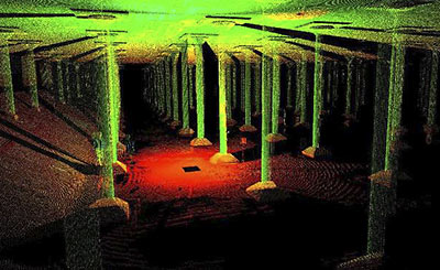
Now have at it: SmartGeometrics has made available for free on a website launched yesterday the data from 3D scans of the allegedly leaky, 87,500-sq.-ft. 1927 underground water reservoir near Sabine St. along Buffalo Bayou. Though the Buffalo Bayou Partnership would like to do something cool with the “accidental cathedral,” as Houston Chronicle columnist and cistern sympathizer Lisa Gray has called it, there’s no more funding available. Thus, the partnership is hoping some smart cookie who knows her way around AutoCAD (and programs like it) will use this free data to come up with an idea that woos someone or something else — like, say, Bud Light — to pay to make it happen.

Image: Buffalo Bayou Park

07/31/13 12:00pm

HINES DEVELOPS WEBSITE TO EXPLAIN 17-STORY SAN FELIPE DEVELOPMENT Much of the information you might want about that shiny office building Hines says it plans to start building this year on San Felipe has been organized — by Hines, of course — on a new website. Like the recently launched ‘Stop San Felipe Skyscraper’ site supported on the ground by that neighborhood campaign of knee-high yard signs, the Hines site presents its side of things in a handy Q-and-A format:Are there other tall buildings in the area? Yes. . . . Will the building reduce the privacy of nearby properties? No. . . . Does Hines care about the potential impact on the neighborhood? Absolutely.” [2229 San Felipe; previously on Swamplot] Rendering: Hines

06/28/13 12:30pm

AN ONLINE HOW-TO GUIDE FOR HOUSTON’S WOULD-BE PRESERVATIONISTS The Planning and Development Department has just launched a website that helps navigate the finicky process of historic preservation. It’s still under construction, of course, but the website works like a manual, explaining, among other things, how to plan a project and obtain those all-important Certificates of Appropriateness. If you’re not into the nuts and bolts of preservation, the website includes a map of the city’s 17 historic districts — including Glenbrook Valley, where this mod at 7919 Glenview was recently restored. Each district is given a little narrative treatment, with drawings of architectural styles and descriptions of pertinent building features included. And if you have no idea what a modillion or a soffit is, there’s even a glossary. [City of Houston Historic Preservation Manual; previously on Swamplot] Photo: Benjamin Hill Photography
03/06/13 11:30am

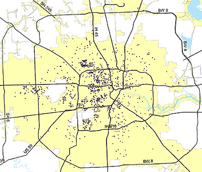
Each of these purple specks — or black holes, depending on your perspective — represents a demolition permit issued by the city in 2012. The planning and development department has posted this and a few other maps online with an overview of demographic data.

After the jump, you can see in more detail the demos inside the Loop from 2012 and 2011, juxtaposed with other maps showing the permits for single- and multi-family construction. You know. For balance:

CONTINUE READING THIS STORY

01/18/13 12:00pm

DOWNTOWN WOULD LIKE TO KNOW IF YOU WOULD LIKE TO SHOP DOWNTOWN Around the same time that Macy’s announced it was closing its store at 1110 Main St., Mayor Parker announced that she’d organized a task force to figure out how to plug up the gaps in Downtown retail; accordingly, the Downtown Management District’s recruiting whichever Houstonians it can to respond to a 20-question shopping survey. It’ll be up through January 31. [Downtown Houston; previously on Swamplot] Photo: Flickr user cjt3
09/20/12 9:59am

Note: Story updated below.

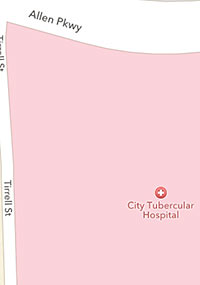
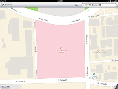
Yesterday, Apple released a new version of its operating system for late-model iPhones, iPads, and iPod Touches, just 2 days in advance of the scheduled appearance of the company’s new flagship, the iPhone 5. A Swamplot reader who took the plunge immediately and upgraded his iPad to iOS6 has been enjoying tours of Houston within the included brand-new built-in Maps application, which in the updated operating system is built by Apple instead of Google. “Notice anything odd about these maps?” the reader asks.

Just a few things so far, the reader answers for us. F’rinstance, a mysterious “City Tubercular Hospital” appears to have alighted on the vacant block west of Dunlavy off Allen Parkway where a portion of the Allen House Apartments used to stand. A large chunk of the Regent Square mixed-use development has been planned for that location since 2008.

CONTINUE READING THIS STORY

07/11/12 3:40pm

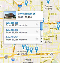
FILLING COMMERCIAL SPACE BY THE SQUARE FOOT A new website launched by a Houston startup aims to simplify the complicated process of leasing and setting up shop in a new office, warehouse, restaurant, or retail space. Kicked off this month with about 1,500 Houston property listings from about a dozen local and national brokers, The Square Foot is targeted at small and medium businesses that have never leased commercial property before. After steering customers to properties that match their criteria, the site intends to smooth out the process of finding helping tenants find furniture, IT services, movers, and related services as well. Co-founder Justin Lee tells Swamplot the site is focusing on Houston for now, but hopes to expand coverage to Texas’s other major cities by the end of the year.

06/22/12 12:10pm

A JUST-OPENED SOURCE FOR HOUSTON BUILDING DATA A 3-month-old website that aims to collect and broadcast detailed information about existing buildings — including photos, square footage counts, ownership and management contacts, projects and renovations, and LEED certification levels — opened its catalog of Austin, Dallas, and Houston commercial and mixed-use structures this week. HonestBuildings.com claims to have detailed online profiles already available on a total of 95,000 buildings in those 3 Texas cities, and on a total of 475,000 nationwide. Many of the Houston listings contain only cursory info so far, but the company is hoping local building managers will provide details to fill out the extensive list of data categories. The New York and Seattle-based startup appears to focus on issues of energy efficiency, allowing companies that provide related services to showcase and target their work — and users to compare building data.
02/14/12 11:45pm

COMMENT OF THE DAY: YOU CAN’T HANDLE THE DATA VISUALIZATION “I think this tool is wonderful for home buyers, now they can actually do research that us agents do. However there are still some very important reports available only to agent. What my clients see so useful is a map/grid type of report. I can take a certain section of a neighborhood and include criteria like … sqft 2000-2500, bedrooms 3-4, counter = granite, built between 2000-2005, one story homes only, lot size 5000-7000, located on a cul de sac, and the house faces WEST…. Realtors have AMAZING TOOLS AVAILABLE TO THEM.. the only problem is some realtors DO NOT know how to use them. Hence our slogan is “Leave Realty to The Pros” …hahahahhaha… Well hope this info helps, if you have any questions please let me know.. IM HERE TO HELP.” [texasrealtypros.com, commenting on New Real Estate Listings Website Reveals Hidden Price Histories]

02/14/12 1:59pm

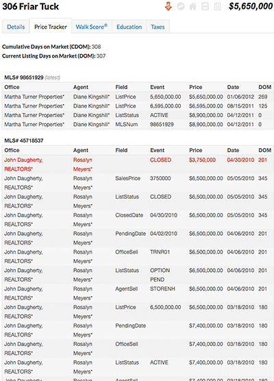
There are more than enough bugs to go around in the NuHabitat beta that officially went live yesterday, but the brand-new real-estate listings website does have one killer feature with the potential to shake up Houston’s real-estate landscape. To registered users, NuHabitat coughs up a set of details that until now were available only to real estate agents: date-by-date, blow-by-blow pricing histories for listed properties — even if the MLS numbers have changed. With these little kittens wandering out of the bag, there aren’t a whole lot of top-secret MLS data fields left to the exclusive domain of real-estate agents.

CONTINUE READING THIS STORY

01/24/12 2:47pm

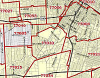
THE NEW ONLINE HOME OF HOUSTON’S MAP TOP TEN Zip Code maps, super neighborhood maps, crime maps, city boundary maps — if there’s a city-produced map of Houston you’re looking for, you’ll find it at the planning dept.’s just-unveiled My City Maps and Apps page. The page is peppered with (mostly working) links to the city’s main GIS My City map viewer (newly updated with 2010 aerial photos) and other services such as the still-in-beta, still Internet-Explorer-only electronic Development Review Cycle system for tracking platting, variance, and development applications. [Planning Dept.]

07/08/11 2:33pm

Whatever your ethnicity, it’s probably not too far off from that of Julie, the Sitepal avatar some fun folks at Rebuild Houston have been using to narrate a series of videos demonstrating how to look up and recalculate the new drainage fee on your property using the city’s Drainage Utility Charge Viewer. Julie’s kinda like you — only maybe she moves and talks a little more stiltingly, and she probably wears more makeup. She’s probably also a little less concerned about the resulting monthly costs, or the imperviousness of the whole thing. Still, Julie’s a trooper: She appears to be standing in the middle of Buffalo Bayou, getting her own feet wet as she processes the script into remarkably natural-sounding speech, blinks occasionally, and convincingly wiggles her lips to the words.

CONTINUE READING THIS STORY

06/23/11 2:07pm

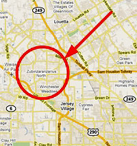
ALSO SPLAIN ZUBINZARANZARIUS “By chance this morning, I needed to find a certain place in Houston. So I opened my trusty web browser and went to the main Google Maps page. I started zooming in . . . and at a certain level of zoom, a very funny word sort of popped out at me near Jersey Village – ‘Zubinzaranzarius.’ I zoomed in more, and it appears to be the name of a legitimate neighborhood — Zubinzaranzarius North. A quick Google search returned a bunch of websites offering to find a house, schools or spas near ‘Zubinzaranzarius North’ — but none of that confirmed the real existence of the location, since those sites probably just mine Google Maps data. Does such a funny-named locality really exist, or did a Google Maps programmer play a practical joke on Houstonians and Jersey Villagers, or did Google Maps get HACKED???” [Swamplot inbox]