Articles by

Christine Gerbode

07/25/16 4:00pm

1901 N. Main St., Near Northside, Houston, 77009

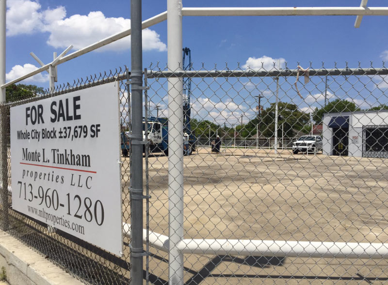
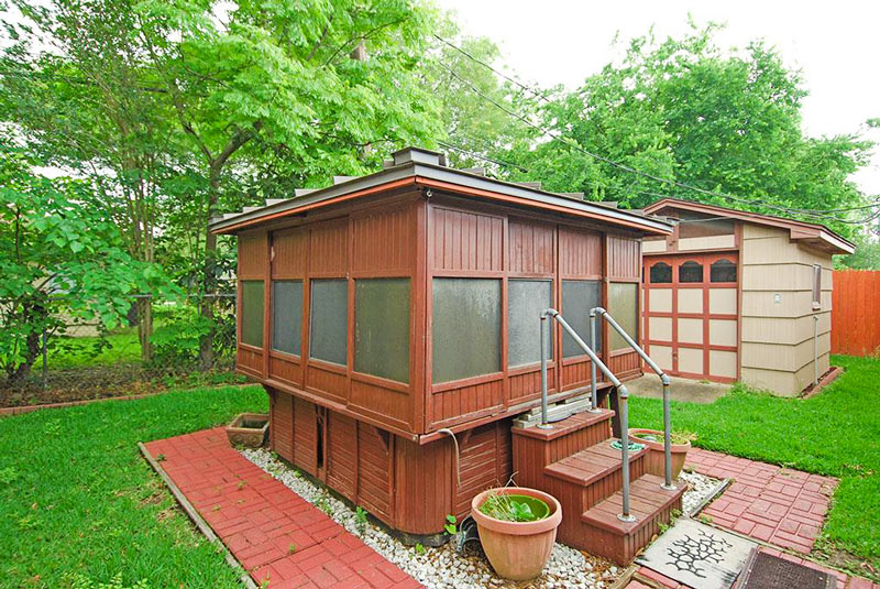
Chris Andrews has caught a few snapshots of what appears to be a soil sampling crew at work at 1901 N. Main St., formerly the site of Uncle Johnny’s Good Cars. Most of the 37,679-sq.-ft. property, occupying the block on the east side of N. Main between Hogan and Gargan streets (including the 1950s auto shop and the next door 1930s Beer’s Building), was transferred to a legal entity called Cerveza Four in May of 2015. Shortly thereafter, Keller Williams Realty posted the cheerily-soundtracked video listing below showing the ins and outs of the property, nestled between the Casa De Amigos city health clinic to the south and the former home of Alamo Thrifty Bail Bonds (now bike shop HAM Cycles 2) across Gargan:
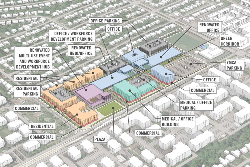
CONTINUE READING THIS STORY

Movement on N. Main
07/25/16 12:30pm

CROSS-COUNTY ACCOUNTING FOR THE HOUSTON FLOODING PUZZLE Katy Prairie Conservancy west Houston map
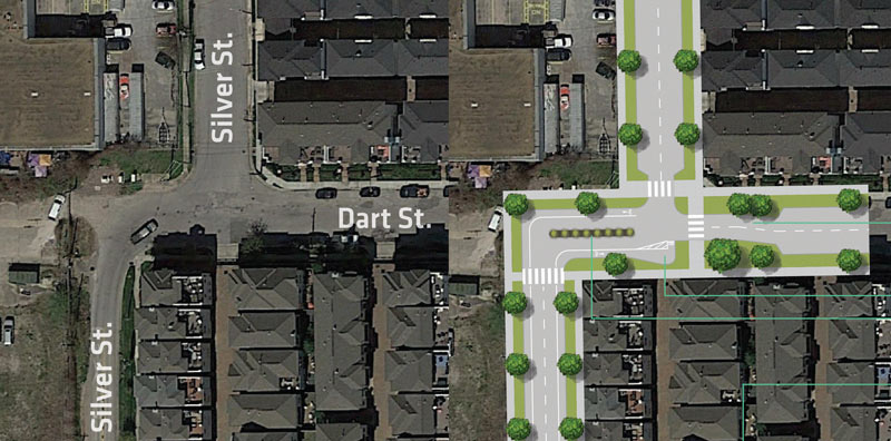
Kim McGuire checks in on the local hardscape in Friday’s Chronicle, as part the latest piece in a series examining roots of the area’s chronic flooding habit. The Houston Area Research Council tells McGuire that roughly 337,000 out of 1.1 million acres of Harris county were covered by surfaces impervious to rainfall runoff as of 2011 (the most recent year of data); meanwhile, softer surrounding counties (including the ones hosting much of the much-reduced Katy Prairie) have been racing to catch up with much higher rates of added hard area. McGuire notes that while developers are generally required to add detention basins to projects that increase the rate of runoff from their land, this does not actually require them to “eliminate runoff from their projects.” Mark Mooney, an engineer for Montgomery County, also tells McGuire that despite the regulatory scrutiny on any individual project with respect to keeping a balance betweeen added runoff and added detention, its still “clear [that] the way water moves through our county has changed. It’s all part of a massive puzzle everyone is trying to sort out.“ [Houston Chronicle; previously on Swamplot] Map of Houston drainage and current/historic Katy Prairie extent: Katy Prairie Conservancy

07/25/16 10:45am

3rd incarnation of Georges Bistro, 219 Westheimer Rd., Lower Westheimer, Montrose, Houston

3rd incarnation of Georges Bistro, 219 Westheimer Rd., Lower Westheimer, Montrose, HoustonHere’s the freshest shot out there of the house-turned-restaurant at 219 Westheimer Rd. between Mason and Helena streets, now open once again as Georges Bistro (but no longer under the management of Georges and Monique Guy, who previously opened and later reopened the spot with Georges-centric names.) After some months of shopping the place around, the Guys closed the French cafe near the end of March to move back to France. The restaurant has since reopened with a hybrid Mediterranean menu, live music, and an upstairs hookah lounge.

Photos of Georges Bistro at 219 Westheimer Rd.: Swamplot inbox

Bon Voyage and Bienvenue
07/22/16 5:15pm

Yucatan Taco Stand, 3407 Montrose Blvd, Houston, TX 77006

The strip-center position formerly held by Berryhill Baja Grill at the corner of Montrose Blvd. and Hawthorne St. is getting new signage this afternoon, a reader notes. The spot appears to be shifting from West Coast to Gulf Coast culinary traditions under the impending occupation of Yucatan Taco Stand. The chain, whose name (almost) maintains all the rhythm and rhyme of the last taco-wielding tenant, was started in Fort Worth by the late founder of Fuzzy’s Tacos, and already has a spot open in the Woodlands.

Here’s a wider view of the scene, showing the restaurant in place next to Nails by TM and back-to-back with the Consulate General of the People’s Republic of China:

CONTINUE READING THIS STORY

Going Yucateca
07/22/16 4:30pm

METRORail Light-rail Map

In response to word from the Chronicle‘s Dug Begley this week that the Red Line’s Reliant Park light-rail stop might get its station name updated to an even older name, a Swamplot reader jumps on the case with a system-wide list of potential station name changes that might remain unaffected by the sale, rebranding, or demise of any nearby venues or landmarks. Begley notes it could cost Metro around $486,000 to change the Reliant Park stop’s signage. The agency says it would prefer to make the switch at the same time as 2 other station name changes currently under consideration (if they’re approved) — but not until after the Super Bowl, for which a set of cheaper temporary stickers will be deployed to help visitors find NRG Stadium.

The reader, in the spirit of Houston’s budding redesign-it-yourself urban planning scene, suggests that paying up now to swap out all the names that might become a problem later might actually be a long-term cost-saver. The proposed scheme makes sure every station name mentions a cross-street (or maybe a bayou), and keeps some references to existing transit centers, parks, or neighborhoods.

Here’s the full list of suggested switch-outs, separated by rail line, with the current names on the left:

CONTINUE READING THIS STORY

What’s In a Name
07/22/16 2:15pm

CHEVRON TO SELL OLD BELLAIRE CAMPUS, ALL THAT NEW LAND ON CLAY RD. 1500 Smith St., Downtown, Houston, 77002Nancy Sarnoff notes this afternoon that Chevron will be selling off that 103-acre Clay Rd. tract it bought in 2014, along with the company’s Fournace Place campus in Bellaire (whose sale was noted last week by Michelle Leigh Smith).  Despite assurances last year that the office midrise at 4800 Fournace would remain occupied, the company says it will move all of those employees to some of its downtown offices by the end of next year, and will start shopping it around in October. Leigh also notes some of the 28-acre property’s recorded history, including the 1940s and 50s laboratory buildings previously demolished on the site, and Chevron’s (then Texaco’s) purported 1970s request to the Bellaire city council to rename the road to something not reminiscent of their competitor Gulf Oil — the property was originally listed on Gulfton St., which now changes abruptly to Fournace Pl. at of the intersection with S. Rice Ave. [Houston Chronicle; Southwest News via Realty News Report] Photo of Chevron’s office tower at 1500 Louisiana St., previously Enron Center South: Jordan R.

07/22/16 11:30am

Jackson Dog Park, 4828 1/2 Loop Central Dr., Pin Oak, Houston, 77081

Update, 2:30 pm: Commissioner Steve Radack tells Swamplot that the dog park itself will also be closed while the parking area is inaccessible. This article has been updated.

Jackson Dog Park, 4828 1/2 Loop Central Dr., Pin Oak, Houston, 77081 A well-labeled notice was spotted by a reader at the Danny Jackson Family Dog Park on Westpark Dr. (south of the Houston Post-turned-Chronicle complex, just inside the West Loop). The sign includes what appears to be a letter addressed to Mike McMahan of Harris County Precinct 3’s parks department, affectionately sign by CenterPoint Energy (which owns the electrical transmission corridor currently borrowed in part as parking for the linear dog run). The note indicates that some or all of the dog park’s lot may be off limits as the company takes care of some work to raise its transmission structures (which cross over the 610 Loop just south of where Westpark crosses under), to get them out of the way of some TxDOT road work planned for the area.

Swamplot is still waiting to hear back as to whether the park itself will stay open Precinct 3 says that the park itself will also be closed during the work period, which the letter says will run from August 15th through June 1, 2017. We’ll update as soon as we have more info; meanwhile, here’s a closeup of the text:

CONTINUE READING THIS STORY

Marking Territory
07/21/16 5:00pm

downtown-tour-1

A set of skeletal construction updates are the product of Bob Russell’s downtown photo hunt earlier this week. The view above is a Hines 2-fer: Behind James Surl’s spiky Point of View sculpture is the 32-floor apartment building on its way up at the corner of Travis and Preston (now going by Aris Market Square), with a sliver of all-business 609 Main visible on the right. The office tower has been getting its last few bits of steel stuck into place this week — check out a more centered portrait of the rooftop action (plus more covert snaps of bare beams from around the area) below:

CONTINUE READING THIS STORY

All On The Way
07/21/16 1:15pm

Palm Center Redevelopment Conceptual Plans

Like the looks of the conceptual drawing above, showing one of the possible ways to dress up HBDi’s Palm Center on Griggs Rd.? Or think you’ve got a better idea, and the real estate connections to pull it off? Adolfo Pesquera notes a current call for proposals from developers interested in redoing the site — you’ve got until early October to submit your own plan.

The changes wouldn’t happen all at once: HBDi’s documents show that it hopes to split up the work into a few different phases, dependent on how the economy looks. The first order of business would be to pretty up the old buildings on the site; the next phase would include adding a plaza and some office space, followed by the addition of whatever mix of office, retail, residential, and medical space is eventually selected.  Though most of the images included with the proposal guidelines are speculative, HBDi’s conceptual drawings do show some of the more concrete plans for the site, which is the last stop on Metro’s Purple Line:

CONTINUE READING THIS STORY

Rearranging The First Shopping Center
07/21/16 10:45am

Thornsen Streetlab Silver St. Redo

In the small but growing city tradition of redoing street plans in your spare time, urban planner and general Houston improvement brainstormer Jesse Thornsen has recently launched a website to showcase weekly ideas for making bits the local streetscape easier to navigate (by bike, foot, car, or other means). This morning’s addition: how to smooth out the westward jog in Silver St. as it crosses Dart St. The spot (shown in the above left-to-right conceptual before and after) is southeast of Annex Houston automobile storage and the Silver Street Studios complex; not quite due west lies the Shops at Sawyer Yards warehouse retail redevelopment.

Thornsen’s plan adds sidewalks and a landscaped median (to discourage vehicles from taking the most direct route straight through the jagged intersection). Thornsen points out that the section is designated for both bikes and cars by the Houston Bike Plan; his redo includes bike lanes, including a queuing spot big enough for multiple cyclists to cozy up together as they wait to turn north. Here’s a close up and a cross section:

CONTINUE READING THIS STORY

Squaring Up in First Ward
07/20/16 3:15pm

COMMENT OF THE DAY: WHAT’S REALLY STALLING HOUSTON’S DRIVE FOR SMOG REDUCTION Transit Frustration“ . . . The serious ways to improve air quality in Houston are 1) to pass California emission standards for all vehicles, and 2) to install traffic light road sensors at intersections. I can’t believe how long we sit at intersections with no one moving.” [KB, commenting on Building for Baby Boomers; Revamping the Briar Club in Upper Kirby] Illustration: Lulu

07/20/16 1:30pm

BUCKHEAD: ASHBY HIGHRISE IS STILL HAPPENING, BUT THAT’S STILL NOT ITS NAME Ashby Highrise, 1717 Bissonnet St., Boulevard Oaks, HoustonChronicle reporters Nancy Sarnoff and Erin Mulvaney spend some time on this week’s Looped In podcast dissecting some circuitous answers from Matthew Morgan and Kevin Kirton, developers of the multifamily project commonly known as the Ashby Highrise (which, as Morgan is quick to point out, has never been dubbed anything other than 1717 Bissonnet except by neighborhood opposition campaigners). In the wake of Buckhead’s recent court appeal victory,  the duo of duos touches on the project’s permitting history with the city, the ambiguous but active state of current plans, and the unexpected financial and emotional tolls of pushing a project forward through an unprecedented decade of protests (ranging from giant personalized signage aimed at the pair to that grim reaper sighting on Bissonnet).  [Looped In Podcast from the Houston Chronicle; previously on Swamplot] Rendering of 1717 Bissonnet St.: Buckhead Investment Partners