06/07/12 6:46pm

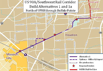
A public meeting at the Together We Stand Christian Church tonight is the third of 4 Metro has scheduled to discuss the possible route of a new 9-mile light-rail leg connecting Missouri City to the southernmost stop on the existing light-rail line, roughly paralleling US Route 90A. Metro isn’t anticipating construction of the extension before 2017, but there are a couple of kinks to consider: The main difference between the 2 route alternatives being considered is the northeast end of the journey. The first alternative (above) jogs off 90A to follow Bellfort into the existing Fannin South rail station, while the second (below) takes the Holmes Rd. route in:

CONTINUE READING THIS STORY

05/15/12 12:06pm

The hip-hop spokeskids for Houston’s transportation agency are out with their second CD — though, as Houston Press music editor Chris Gray notes, it appears that in at least one video by the Transit Boyz, the rapping progeny of Metro employees have been replaced by puppets. Puppets modeled after the Beastie Boys. A few other references are thrown in too: “We like big buses and we cannot lie.” Yes, they really did just say that.

CONTINUE READING THIS STORY

12/28/11 11:37am

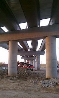
Reader Heidi Hagen’s photos of construction on the North Line along N. Main St. north of UH-Downtown show the new bridge that’s “popped up outta nowhere” around Hogan St. No, there’s no rainbow at the north end of Downtown, but if you look carefully from the right far vantage point can see the elevated concrete and steel construction that’ll be carrying an extension to the existing rail line over the Union Pacific railroad tracks to further points north: Lindale Park, the Northline Transit Center, and 6 other newly named stations. More bridge pix from earlier in the month:

CONTINUE READING THIS STORY

12/20/11 7:04pm

16 of the 25 official station names announced today for Metro’s new East End and Southeast light-rail lines and North Line extension include slashes. No, you won’t need to choose between Cesar Chavez and 67th Street: The Cesar Chavez/67th St. station will honor both. Same for MacGregor Park/MLK. The term “EaDo” has made it on to a station name — but only as part of the EaDo/Stadium team — not to be called “EaDo Stadium” of course, since Spanish bank BBVA Compass just paid a lot of money for the exclusive naming rights to the new soccer venue.

A few other station names you’ll want to be careful with:

CONTINUE READING THIS STORY

10/28/11 11:09am

From those rockin’ dudes at Metro, moving to their own beat: a timelapse view of last weekend’s marathon Friday night to Monday morning East End Line construction project at the intersection of Harrisburg and Lockwood. (Traffic lanes and utilities had already been installed.) The beat goes on. . . .

Video: Metro

10/10/11 8:42am

FREE CNG BUSES WILL CRISSCROSS DOWNTOWN Beginning next spring, a new free shuttle service called Greenlink will connect the George R. Brown Convention Center to City Hall — and about 20 stops along the way. The fleet of seven 30-ft.-long buses running on compressed natural gas is being paid for by the Downtown Management District, Houston First (the new corporation that now operates the convention center), and British gas company (and new Downtown tenants) the BG Group, with help from a grant from the Federal Transit Administration. Buses will run every 20 minutes along the 2.5-mile route from 6:30 am to 6:30 pm on weekdays only, and every 7 minutes at lunchtime and other peak traffic times. Update: Stops haven’t been chosen yet, but here’s a route map. [Houston Chronicle] Photo: George R. Brown Convention Center
10/05/11 12:50pm

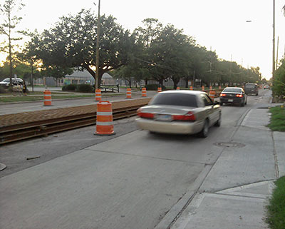
A reader sends in this photo showing the results of a recent heavy metal delivery to the median of Fulton St. across from Moody Park: Rails, for the coming 5.3-mile North Line extension to Lindale Park. Swamplot’s Northside construction correspondent reports the street appears paved and ready for the tracks to be installed.

Photo: Swamplot inbox

08/11/11 11:46am

THERE GOES YOUR POPULAR LOW-COST AIRPORT SHUTTLE SERVICE, HOUSTON Saturday, August 20th will be the last day for Metro bus 500, the half-hourly Airport Direct route from Downtown to IAH. Metro’s board voted to end the service last month because of low ridership and continuing revenue losses. A reduction in fare from $15 to $4.50 and the addition of several hotels to the route this past January increased the number of riders but “did not reach a level where the service could be sustained,” according to a Metro statement. The service had been in operation for 3 years. Committed Metro airport passengers will still be able to ride the 102 bus, which costs just $1.25 — but it’s not an express route. [more info; previously on Swamplot]

08/10/11 2:49pm

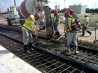
Seen at this morning’s Purple Line kickoff on McKinney St. near Ennis in East Downtown, a sight not seen around Houston since before 9/11: What it looks like when Metro contractors lay track for a new light-rail line . . . or pour the concrete pad for it, anyway.

Photo: Metro

08/09/11 1:58pm

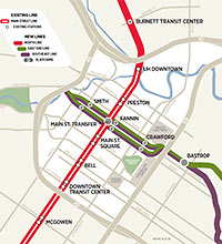
Has it really been 10 whole years since any new tracks have been laid for any Houston light-rail lines? Not exactly. It’s been 9 years and 11 months. To celebrate the occasion, Metro is holding a small ceremony tomorrow to place the concrete base for the very first tracks on the new Southeast, or “Purple” line. Tomorrow’s morning pour will take place at 2979 McKinney St. near Ennis in East Downtown, but the 6.6-mile Southeast Line will run all the way from a new station on Smith St. to the Palm Center, with stops at Fannin (change here for the existing “Red” line), Crawford (baseball, anyone?), Bastrop (soccer?), Leeland, Elgin then Scott St. (both at the western edge of UH, crossing the path of the proposed University Line), Wheeler and MLK (on the other side of campus), and MacGregor Park along the way:

CONTINUE READING THIS STORY

08/02/11 3:30pm

HAIF poster ricco67 adds to the collection of videos showing views along the paths of the under-construction or promised light-rail routes with this mostly accurate west-to-east drive-through of the promised University Line, from Hillcroft to Eastwood. It’s a long trip, made only a little faster by the absence of any Metro construction work along the way.

Video: ricco67

06/13/11 4:54pm

A web app put together by a 23-year-old German programmer lets you figure out how far you can travel on public transportation within a specific time period from any point in Houston — and 60 other cities worldwide. Give Mapnificent an address and a time limit (say 15 minutes) and it’ll mark on a Google map what areas of town are within your reach. Tell the app if you’re lugging around a bike or the maximum distance you’d be willing to walk to a stop or station and the resulting shapes will change accordingly. As Stefan Wehrmeyer’s video above demonstrates, you can also use Mapnificent to figure out areas where you and your car-shunning friends could meet up within 20 minutes — as well as all the coffee-shop, bar, nail-salon, or Apple Store hangouts available to you. More generally useful: Mapnificent can generate a heatmap for any location, showing what neighborhoods around any particular address are quicker or slower to reach by bus or train. (Note: If you don’t have Firefox, Chrome, Safari, Opera, or a car, you’re out of luck. The app doesn’t work on Internet Explorer.)

Video: Stefan Wehrmeyer

09/27/10 4:01pm

METRO MANAGERS TO RIDE OWN DOG FOOD A new requirement for Metro senior managers: riding public transportation 40 times a month. That’s from George Greanias, the transit agency’s now-official president and CEO — who counts as one of those senior managers. “Some of the same executives will be affected by cutbacks in Metro’s use of car allowances and staff take-home cars, Greanias said. Only employees whose daily duties require using vehicles will receive these benefits; others will simply be reimbursed for Metro-related mileage on their personal cars, Greanias said.” [Houston Politics]

03/31/10 9:54am

PEARLAND FINDS ITS PARK AND RIDE SPOT Metro will build a Park & Ride lot on 12 vacant acres at the gateway to the Southfork subdivision, at the southwest corner of Highway 288 and Airline-Ft. Bend Rd. (otherwise known as County Road 59): The board also authorized staff members to execute a design-build contract with the unidentified property owner that ‘will allow them to build the complex in accordance with Metro’s specifications and do it quicker,’ [Pearland assistant city manager Jon] Branson said. The facility will be a base for commuter shuttle buses between the Pearland area and Houston, including the Texas Medical Center. It is expected to provide much-needed traffic relief for residents who live in or near Shadow Creek Ranch and Pearland Town Center, [Metro vice president Kimberly] Slaughter said. The Texas 288 corridor averages about 96,000 vehicle trips a year, Branson said. When the shuttle facility opens this fall, it will have parking to accommodate 750 vehicles. Another 750 parking spaces will be added later, Branson said.” [Ultimate Pearland]

03/19/10 4:16pm

Here’s a little handy graphic from Mayor Parker’s Metro transition task force, identifying what the team considers “major unresolved design issues” in the planned East End, Southeast, University, and Uptown light-rail lines. Attempts to resolve all 6 of them appear to be “bogged down” at the Metro staff level, according to the task force committee. Each problem might delay construction or increase cost, and each has already been “actively discussed” for at least a year.

What are they?

Oh, and then there’s this little bit about finding the money to build it all:

CONTINUE READING THIS STORY