COMMENT OF THE DAY: BURIED LANDSCAPES OF THE HOUSTON HEIGHTS “Before developers established the heights and its various neighboring subdivisions, a massive filling project took placed. It was pretty much a landfill for the City of Houston. . . . Developer clear cut the existing pine forest (the oaks pretty much only existed near the bayous and tribs) and filled in the uneven landscape. A big example is in Woodland Heights. A 60-inch storm sewer line runs in an old trib to White Oak Bayou. The line is 20-ft below the current natural ground in the area. After the line was built, the natural channel was filled in and streets placed on top. The line currently goes under many people properties and houses and many don’t know it exists. . . . Outside of that, several ox bows and other trib were filled in. A couple were not though. There is one just east of TC jester where it cross White Oak Bayou south of 11th. It has water in it. There is another just west of Yale that is dry. I’ve seen historic photos showing people jumping off the banks of the the natural streams in the bayous in the Clark Pines area (14th street west of Durham). A current development is actually being build on an undeveloped piece of land that was a site of the landfill in this oxbow. The houses are being placed on piles driven deep into the ground to avoid them from sinking or collapsing. I doubt they are telling the home buyers this. Long time residents know about it though.” [kjb434, commenting on Wet and Wild: Strip Redo on White Oak]
Tag: Flooding
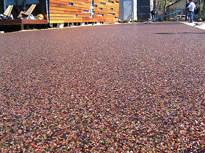
Next experiment at that Swamplot-Award-winning house built out of shipping containers on Cordell St. in Brookesmith? The unique driveway installed earlier this week. John Walker of Numen Development writes in with details:
It is composed of recycled crushed glass, with a resin binder, and achieves the consistency of caramel popcorn for lack of a better description, so it has voids that allow surface water to percolate through the paving and ultimately be absorbed into the underlying soil rather than running off into the storm drainage system. It is a triple threat: recycled material, reduces environmental impact of development, and it’s really cool!
Walker says Presto Geosystems, a division of Alcoa, installed the driveway as a pilot project for the Houston market.
This installation has been described by their consulting engineer as most likely the “first and last” residential project they will do in Houston as the product is expected to meet with huge commercial demand, especially for “landlocked” developments for whom expansion is limited by Harris County stormwater detention limitations.
Some views of the installation:
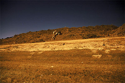
 The high point of River Oaks Examiner reporter Rusty Graham’s tour of Project Brays, where flood control is measured in Astrodomes: sheep — on an actual hill — overlooking Brays Bayou flood-reduction projects at the Eldridge Road basin.
The group arrives at the Eldridge detention basin, at the end of Westpark. Harris County Precinct 3 is developing Archbishop Joseph A. Fiorenza Park at the facility, which is about 45 percent complete.
Eldridge is the largest of the four basins, with a total area of 337 acres. Eldridge will hold 1.5 billion gallons of stormwater when complete, or nearly three Astrodomes.
One of the highlights of the trip is seeing the sheep on a large hill on the west side of the Eldridge basin. The 60-foot hill is built from dirt excavated on site.
The sheep lived in the area before the site was purchased, says Heather Saucier, spokeswoman for the flood district. They’re tended by an area resident, although on this day they seem to be doing well enough on their own.
The hill’s summit offers a commanding view of the area, and is especially impressive looking back towards the Uptown area to the east.
- Down on the bayou: Massive project to reduce flooding [River Oaks Examiner]
- Brays Bayou Project Locations [Project Brays]
Photo: River Oaks Examiner
PAY NO ATTENTION TO THE BAYOU Lisa Gray gets a glimpse of the “chai-colored” waters of Berry Bayou behind her 1966-model Meadowcreek home: “Most of the new houses sprouting in the neighborhood did their level best to ignore the bayou. Most of them still do; it’s rarely a selling point. A year ago, I was delighted to find that not only was it possible to buy a non-flooding bayou house for $150K, but that it might not cost any more than a similar three-bedroom house on a neighboring suburban lot. On har.com’s real estate listings, bayou frontage either went unmentioned or hid under the faint praise ‘no backyard neighbors’ — the same thing sellers say when a house backs up to train tracks. When first looking at the house I now live in, I had to stand on an overturned bucket to see over the privacy fence and down to the water.” [Houston Chronicle]
An awful stench has been wafting through the homes of Golden Glade Estates, just west of Hobby Airport and south of Sims Bayou. There’s also been backyard flooding after every rain, a constant din from trucks, and generator-powered lighting beaming into local Living Rooms during the night. The cause? Huge piles of wood debris, brought into the southeast Houston neighborhood after Hurricane Ike:
Their problems started when Federal Emergency Management Agency contractors began trucking in hundreds of semi truckloads of pungent smelling, steaming mulch. Local 2 Investigates cameras and Sky 2 helicopter footage show some mounds stacked taller than nearby homes, covering acres of land less than 100 yards from some homes.
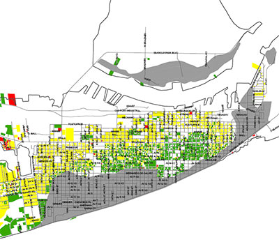
FEMA-approved colors liven up this property-damage-assessment map for 24,000 structures in Galveston.
The red areas are “unsafe; leaning; structurally unsound; completely destroyed; collapsed or structure missing.”
Yellow means “general interior flooding; wind damage; or significantly damaged, but repairable.”
And green means go! “No damage or only minor damage; or missing siding; shingles; handrails; breakaway walls.”
The gray areas? “Flood zone.”
More colorful maps of other Hurricane-Ike-hit areas of the city are available on the City of Galveston website.
- Damage Assessment Map for Areas 61st Street East, 61st Street West to Jamaica Beach, and Jamaica Beach West to San Luis Pass as of 10/15/08 [City of Galveston, via Hair Balls]
- City Releases Damage Assessment Map & Issues Guidance for Property Owners [City of Galveston]
THE FINANCIAL CRISIS: KINDA LIKE FLOODING IN MEYERLAND A rising tide sinks all prices! “When Dr. Mahmoud Amin El-Gamal, chairman of the Rice economics department, is asked — as he has often been in recent days — ‘What’s is going on with our financial institutions?’ he likes to begin his answer with an analogy of local origin. ‘It’s a lot like in the 1980s when the flooding in Meyerland caused the price of all the houses in the area to go down,’ he said, ‘even those houses that did not flood.’ El-Gamal said the same can be said of mortgage securities, many of which were ‘perfectly fine,’ but had been grouped with debts that would likely continue to go unpaid.” [West University Examiner]
MIDSUMMER BOOKS: 8 FEET IS ENOUGH This fall was the final season for Midsummer Books, near the Strand in Galveston: “‘All those shops and restaurants on Strand, Mechanic and Postoffice were hit bad, and Midsummer Books got 8 ft of muddy water which soaked and ruined everything, books, furniture, computer equipment, etc.,’ owner Tim Thompson says by e-mail. ‘Luckily I have flood insurance so I will most likely get compensated for the loss. However, this is one of those times in life where tough decisions have to be made and for a variety of reasons I have decided not to ressurect Midsummer Books,’ he says.” [Hair Balls]
SHOULD GALVESTON BE REBUILT? “The city and its environs rest on barrier islands, which are made of sand, low-lying and prone to significant geological shifts. In Galveston’s case, even before Ike’s landfall, the island was both sinking slowly and becoming sharply eroded along its west end. Moreover, a couple of years ago, the city itself commissioned University of Texas geologist Jim Gibeaut to create a geohazards map for the island, that is, where should development not occur? The research study found that nearly all the development along the beach front west of the seawall, which protects the core of the island, is in ‘red’ or ‘yellow’ zones, where Gibeaut says development should not occur.” [SciGuy]
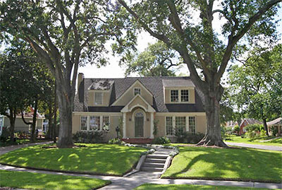
Remember this house from July, featured as the subject of our weekly Neighborhood Guessing Game? Yeah, the one with the wacky carpet in the garage apartment. On the corner of N. Macgregor and Wildwood Way, on the left bank of Brays Bayou in lowest Idylwood.
Well, the pre-Hurricane-Ike storm surge brought it some problems. Sad photos below:
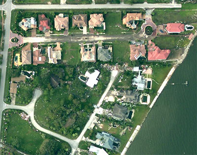
Having trouble finding photos of your Iked house on Flickr? Try finding it from the air, using NOAA’s brand-new aerial photos, taken only a few days after Hurricane Ike.
Aerial photo of Villa Dr. in Seabrook after Hurricane Ike: NOAA
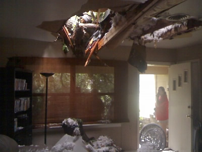
From the seemingly ubiquitous Pankaj, a few choice images of Hurricane Ike kicking some Houston ass:
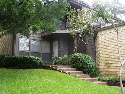
That Sunday open house scheduled for this townhome at 18224 Lakeside Ln. in Bal Harbour Cove on Clear Lake? Probably not going to happen. Sadly, it may be that the only open houses taking place in the Houston area this weekend will be unscheduled ones.
If you find any impromptu open houses taking place in Hurricane Ike’s wake, how about adding them to this weekend’s Open House Tour? Send pix to the Swamplot tip line, or add your comments or directions below. Have any other Hurricane Ike photos, videos, or stories you’d like to share?
They didn’t name this site Swamplot for nothin’! Now’s as good a time as any to stake our claim on the Google as the go-to website for photos, videos, and salty tales from Hurricane Ike — of waterlogged, flooded, or otherwise fluid-besmirched homes and businesses in the greater Houston and Harris County areas. Have we stuffed enough sticky keywords into this post yet? How about real-estate damage resulting from Category 2, 3, 4, or 5 hurricane-force winds in Southeast Texas? Yeah, come here for that stuff, too.
And where will all these videos and photos and stories come from? How about . . . from you? You’re charging your camera phone anyway — and loading up the address book with email addresses . . . Why not add Swamplot’s tip line to the list?
Once you’ve captured it, send us that great shot of newly waterfronted property — just tell us where it was taken and who to credit. If your neighborhood stays high and dry, send in the pics to prove it! It might make things a whole lot easier a few years from now, when you’re trying to explain to a skeptical potential buyer that your house didn’t flood during Ike.
Of course, it may be a little while before we can post the stuff that comes in. It’s all gonna depend how long it takes our laptops to air dry.
We do hope everyone has a safe, dry, and floating-ball-of-crazed-fire-ants-free Hurricane Ike experience. Maybe this thing will simply blow over! In any case, why not have your camera ready?
- We Only Know What We Read in Our Email [Swamplot]
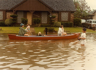
Photo of flooding after Hurricane Alicia, Houston, 1983: Michael Glasgow
IKE TURNS HERE Apparently, some sort of storm is headed this way. If you live in the 77507, 77058, 77059, 77062, 77520, 77546, 77571, 77586, or 77598 zip codes, here’s a little advice: Surfing Swamplot for real-estate news is probably not the best use of your time right now. How about a little gettin’-out-of-town-ing instead? There’ll be plenty of time to gawk at photos of soggy homes right here — after we’ve been soaked and the power comes back on. On the other hand, all you shelter-in-place people: How’s the installation coming along on those foundation bolts and jacks? Got any tips for turning decorative shutters into something . . . useful? And who’s been buying up all the toilet paper? [Houston Chronicle]

