05/18/16 5:00pm

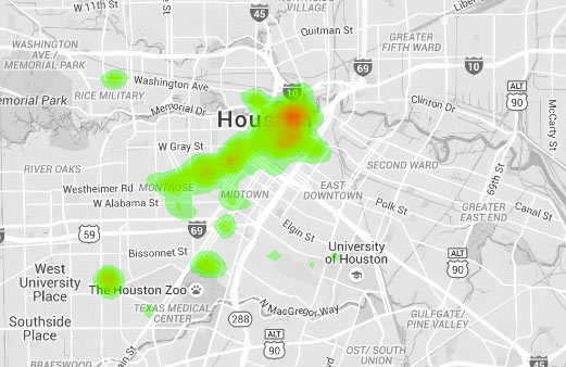
City of Houston parking ticket map by Jordan Poles

The above heatmap showing where city parking tickets are most frequently issued is one result of an in-progress project by biology major and urban data enthusiast Jordan Poles. Areas shaded red mark where the tickets fall heaviest, while green areas see a lighter citation rain. Grey areas are not ticket-free — rather, the colored regions represent notable clusters of ticket activity (including Downtown, Montrose, Fourth Ward, Midtown, the Museum District, and the Rice Village).

CONTINUE READING THIS STORY

Fine Maps
04/27/16 3:45pm

All the little red dots above show storefront retail locations throughout the Houston area. The map comes from Portland-based City Observatory, which just released a shiny new report on using the number and arrangement of customer-facing businesses to guide city planning. The bar in the top left corner lets you jump around between Houston and the 50 other cities mapped by the project.

Like the other studied towns, Houston is shown with a black ring marking off a 3-mile radius around Downtown. A closer look at Downtown shows a sharp divide in storefront density across the Main St. corridor: 
CONTINUE READING THIS STORY

Marking the Market
04/21/16 10:30am

road-closures-4-21

Replacement work on the Yale St. bridge over White Oak Bayou now won’t start until the 25th, according to an update from TxDOT. The original planned construction start drifted past in the middle of Monday’s deluge; no changes have been mentioned yet for expected 2018 reopening date.

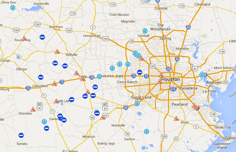
Meanwhile, TxDOT’s Yoakum office says it’s keeping an eye on US 59 in Wharton County to the southwest of town, though that highway is not closed at the moment according to the agency’s interactive mapping system (pictured above). The map shows areas of road closures, flooding, and construction, with written descriptions for each site clarifying which lanes are affected, by what, and how badly. Zooming in further gives a clearer picture of the extent of some of the closures — below is a view of west Houston, showing the stretch of Hwy. 6 near the Addicks reservoir that could be closed for the next 4 to 6 weeks: 

CONTINUE READING THIS STORY

What’s Under Water
04/18/16 2:45pm

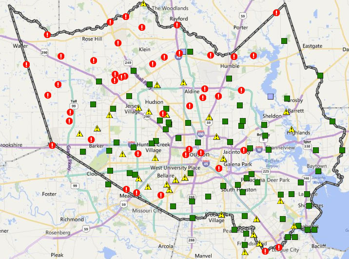
Harris County FWS channel map, April 18, 2016

The many exclamation points scattered across the map of Harris County above mark spots where stream channels are currently overtopping their banks (in red!) or potentially thinking about it (in yellow!). The capture comes from the Harris County flood warning system interactive map, which automatically updates data from its county-wide network of rain and flood gauges every 5 minutes. Most of the current overtopped locations are concentrated toward the northwest areas of the county, parts of which got more than 17 inches of rain since Sunday morning. The green shapes mark channel gauges that aren’t currently at spillover stage or close to it (whether or not any spillover occurred earlier today).

The county’s online map also shows cumulative rainfall across the area — here’s what the totals look like across town for the last 24 hours:

CONTINUE READING THIS STORY

On and Off the Rise
04/06/16 3:45pm

Go ahead and play around with the map above (created by activist Kris Banks), showing the precinct-by-precinct outcome across Harris County for last month’s Republican presidential primaries. Shades of red show the spots won by Cruz (most of them, though a lighter shade indicates less solid support). Precincts won by Rubio show up in shades of blue (mostly clustered on the west side of the Inner Loop), while Trump support is marked in gold (mostly northeast and south of Downtown, as well as strung out along the Westpark Tollway); a few Carson precincts show up in green.

January Advisors’s Jeff Reichmann recently took a look at Banks’s election maps, which include results from both parties’s primaries and a starkly geographically-split down-ballot race for the Democratic district attorney nomination. You can click on each precinct to get its number and a breakdown of the results. Here’s how things looked for the Democrats, with the Sanders precincts in green spangling a field of Clinton blue:

CONTINUE READING THIS STORY

Drawing It Out
03/30/16 4:30pm

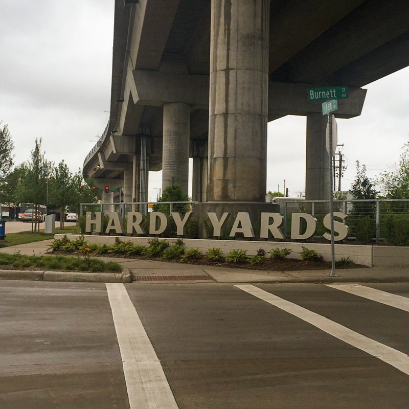
Hardy Yards sign, Burnett at Main St., Near Northside, Houston, 77026

Hardy Yards sign, Burnett at Main St., Near Northside, Houston, 77026

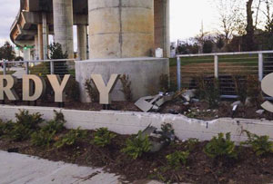
The second A, R, and D of the signage at the intersection of Burnett St. and N. Main are now back in action (up top) beneath the Red Line light-rail overpass. The letters have been patched up and sent back to their assigned places above a freshly-repaired concrete planter, following an unfriendly run-in (or -into) near the end of January (pictured second, with the A dramatically sprawled backward onto the mulch).

The sign, marking the intended redevelopment of the former Hardy Rail Yards into a mixed-use complex in Near Northside, was added as part of the street and infrastructure work that’s been going on at the 43-acre brownfield site. Some of that work is visible in the site plan for the property posted by landscape architecture and planning firm Design Workshop: 

CONTINUE READING THIS STORY

Near Northside
03/15/16 5:00pm

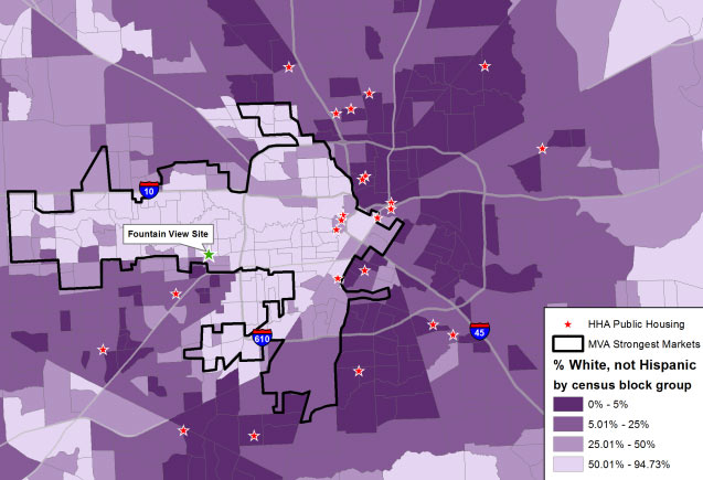
Demographic Map of Houston Census Blocks and Public Housing Projects, from Texas Housers

The pale arrow pointing from W. Beltway 8 to Downtown in the map of Houston above is made up of census blocks recorded as more than 50 percent white, according to a post by Will Livesley-O’Neill for Texas Housers yesterday. The Austin-based nonprofit, which researches low-income housing policy around the state, published yesterday’s article as a followup to some previous posts about the mixed-income housing complex that HHA is planning for the site of its own office building on Fountain View Dr. in Briargrove. The demographic breakdown on the other 3 shades shown on the map, from lightest to darkest: 50 to 25.01 percent white, 25 to 5.01 percent, and 5 to 0 percent.

The map also marks the locations of existing Houston Housing Authority public housing developments as red stars, mostly outside of or skirting the majority-white census blocks; the proposed Fountain View housing site is singled out, tagged, and marked with a green star. Meanwhile, the black outline looping mostly around the majority-white areas is lassoing the market areas deemed strongest by the Reinvestment Fund‘s Market Value Analysis for the city.

Map: Texas Housers

Visualizations
02/26/16 1:15pm

Well, almost: More than 50 Texas schools currently bear the names of Confederate soldiers, writes Drew Blackburn in Texas Monthly. The interactive map above was included in yesterday’s article, which pairs the location of each school with a demographic breakdown of its student body. Back in January, HISD announced its decision to rename 4 of 7 schools in the district named for Confederate figures (including Dowling Middle School, missing from the map); 2 weeks ago, the school board voted to go ahead and rename the other 3 as well. Dallas and Austin have also begun renaming schools.

Map of Texas schools named after Confederate figures: Texas Monthly


Civil War Battlegrounds
12/21/15 1:30pm

Solstice Alignment in Montrose

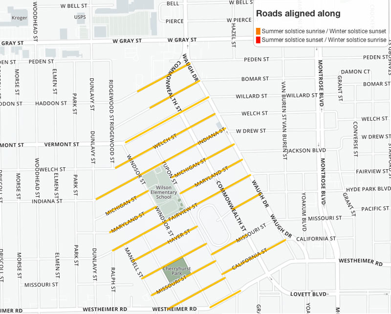
Still hunting for that perfect spot to boil up some fresh eye of newt during tonight’s winter solstice sunset? Github user and mapping fanatic Demeter Sztanko has you covered, a reader tells Swamplot just in time. Sztanko has programmed an interactive map highlighting all the streets aligned with the summer and winter solstices — so you too can get in on the mystical fun from a bit closer to home than Wilshire. Choice picks for an in-line solstice vantage include that entire off-kilter neighborhood north of Westheimer between Waugh and Mandell (pictured above) and certain segments of the South Loop.

CONTINUE READING THIS STORY

G.I.S. for Druids
07/16/15 2:00pm

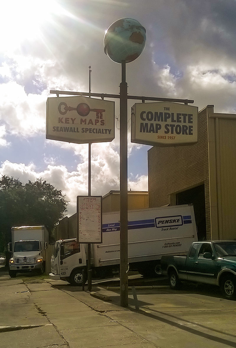
Key Maps Store, 1411 W. Alabama St., Montrose, Houston

Key Maps Store, 1411 W. Alabama St., Montrose, HoustonYou have until tomorrow, maybe, to grab some of the cartographic treasures remaining at the longtime Inner Loop home of Key Maps, Houston’s homegrown map company. Items you buy will be 70 percent off — or free if you fish them from the yellow Dumpster parked out front at 1411 W. Alabama. But it’s a pretty chaotic scene, a reader tells us: Framed wall-maps, Key Map books that used to be found in the back seat pocket of most Houston cars, and other items are being loaded into moving trucks in preparation for a relocation to a new storefront at 5622 Richmond Ave., on the north side of the strip near Chimney Rock.

CONTINUE READING THIS STORY

Which Way from West Alabama
07/06/15 12:45pm

Following up on last month’s Supreme Court decision highlighting the segregation effects of Texas’s low-income housing programs, Chronicle reporter Jayme Fraser has a few observations about how the Housing Tax Credit program has been administered around here — after studying the above map, which she assembled to show the location and details of every Houston-area property involved in the program from its start in 1987 through 2013. Using federal funds, the Texas Dept. of Housing and Community Affairs offers tax incentives to private apartment developers in exchange for guarantees to keep rents on new or rehabbed complexes below the market rate.

CONTINUE READING THIS STORY

Low-Income Housing Map
06/11/15 3:15pm

Which neighborhoods were hardest hit by last month’s floods? Try looking at this map to find answers. Zoomed out as it is, you can see some overall patterns. But to get a sense of the scope of the devastation in certain Houston neighborhoods, you’ll want to zoom in. Into this part of Meyerland, for example:

CONTINUE READING THIS STORY

High Water Maps
04/16/15 2:00pm

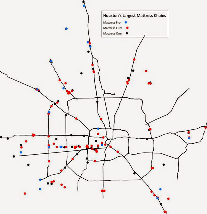
Map of Houston Mattress Chain Stores

Blogger and amateur bedding-sales analyst Christopher Andrews has updated a few of his maps of mattress chain stores in the Houston area (including the one shown above) to include Mattress One (or Mattress1 One, or Mattress 1 One, as the company variously refers to itself). Altogether, that Florida-and-Texas chain, plus Mattress Firm and Mattress Pro (owned by Mattress Firm), operate 166 separate retail locations in the region.


Map: Christopher Andrews

Bed Spread
12/19/14 1:00pm

washington-ave-walmart

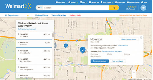
Here’s a map a reader sent yesterday apparently showing the location of “Walmart Neighborhood Market #3450,” on Washington Ave, just east of the newly sold Archstone Memorial Heights apartment complex at 201 S. Heights Blvd. (A different Walmart map shows it in the same spot.)


CONTINUE READING THIS STORY

Mystery Walmart By The Heights Walmart
09/02/14 10:45am

The Chronicle’s Erin Mulvaney has thrown data from Apartment Data Services into this interactive Google map — to give you a zoomable picture of where all the new apartments are heading in Houston. The green pins show the 19,923 units (in 72 projects) that have opened recently; the red dots show the 23,781 (in 85 complexes) that are currently under construction; and the yellow dots indicate the additional 18,065 apartments (in 61 new developments) that are proposed — or at least the ones the data company is aware of.

Map: Erin Mulvaney/Houston Chronicle

Mapping New Construction