COMMENT OF THE DAY: I-10 LOW-BRIDGE ALERT SYSTEM ISN’T EYE-CATCHING TO PASSING TRUCKERS 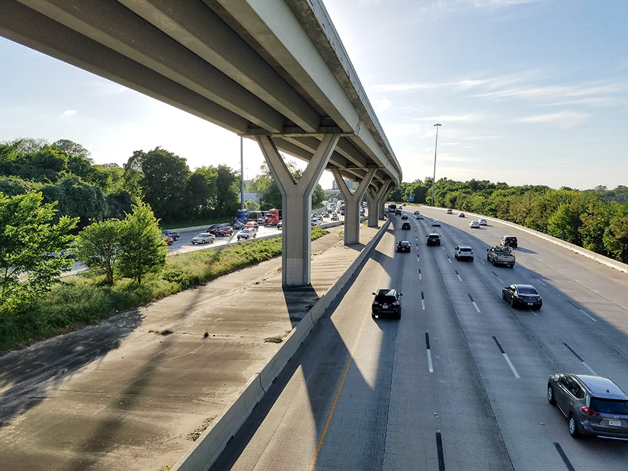 “The sign mentioned in the posting is a joke — it’s small, off to the side, partially obscured, and it is not readily apparent what it’s referring to. Worse than that, it is 2 miles ahead of the 610 interchange, and 7 miles ahead of the Houston Ave. overpass. It is nowhere close to a sufficient or effective system, and along with the new low clearance signs inside the Loop, has every appearance of a band-aid solution to something that needs a more comprehensive approach.” [TMR, commenting on How TxDOT Tries To Stop Trucks from Clipping the Houston Ave. Bridge] Photo of I-10 near Houston Ave. bridge: Marc Longoria via Swamplot Flickr Pool
Tag: Traffic
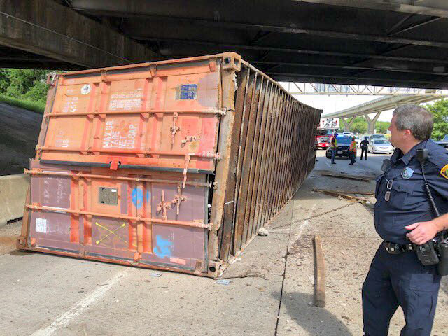
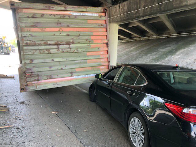
The latest 18-wheeler to drive into the Houston Ave. bridge didn’t make enough of an impact to force repairs yesterday, although it did stall I-10 traffic all the way to T.C. Jester while TxDOT closed 2 lanes to clear the debris (including the truckload pictured above pinning a sedan) and inspect the overpass to ensure its integrity. (The last round of bridge maintenance in March — to repair a strike in December — couldn’t have come at a better time: “Just as crews were putting barriers in place,” for an overnight closure to fix the damaged structure, another truck drove into it — reported Houston Public Media’s Gail Delaughter.)
Over the last 4 years, the 14-ft.-3-in.-high bridge has been hit 22 times — reports Click2Houston; historically, it’s struck “more than any other bridge in the Houston area,” says a TxDOT spokesperson. Not a great track record — until you factor in how many trucks aren’t hitting it as a result of TxDOT’s high-tech warning system. In 2015, the agency installed infrared sensors at Mercury Dr. and Wirt Road that detect oversized vehicles and — if spotted — flash a warning message to get off the road on an electronic billboard. Between January and June 2 of this year alone, the sensors transmitted 13,477 warnings.
- TxDOT using ‘size detectors’ to limit bridge strikes [KHOU]
- Grappling with a pair of Houston bridges that keep getting hit [Click2Houston]
- Bridge Due For Repairs Is Hit Again By A Truck, TxDOT Moves Ahead With I-10 Closure [Houston Public Media]
Photos: Emily Black
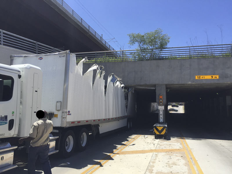
Not to be outdone by last week’s midday plug-up of the Alfred Hernandez Tunnel beneath the railroad tracks and the Burnett TC Red Line stop, another semi making its way through the passage got lodged in the tunnel late this morning — getting torn open end-to-end in the process. But that’s not even the first truck stuckage incident at the underpass in the last 24 hours, according to a reader who’s had both a camera and a Twitter account trained on the recently retooled intersection for at least the last few months.
The reader tells Swamplot that another truck got stuck briefly last night, and that it happens about 6 times a week: “Our camera system auto-wakes when it hears something beyond a certain threshold; most drive away, presumably nervous[ly] on their way to have a talk with the boss.” Some work on the tunnel has been on the city’s docket this spring, and was approved at a mid-April meeting; that’s likely to start around the end of the month.Â
Here’s the scene from above as of early this afternoon:
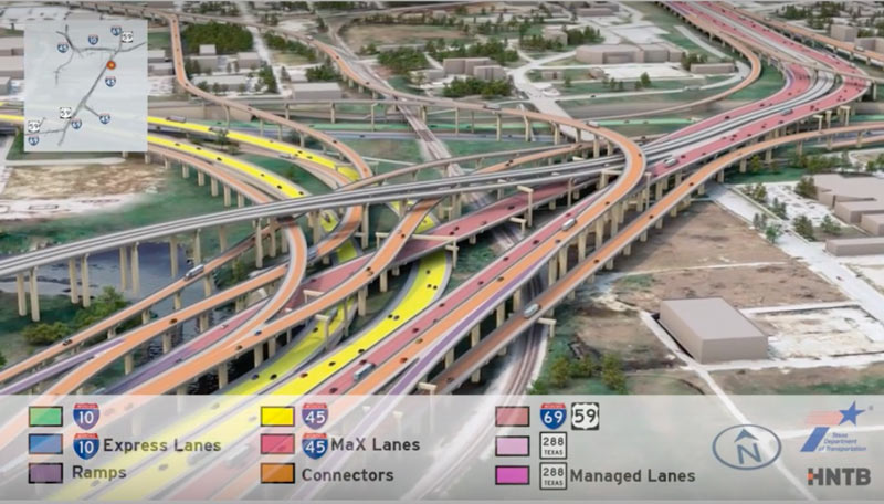
Having trouble sifting through some of the massive freeway jumbles in the latest plans for that major I-45 reroute between Downtown and the Beltway? This new video (making the rounds this month as TxDOT hosts a set of public meetings to chat about the project) may or may not help you out. The 10-minute animation shows off what the project plans look like in multicolored, car-spangled 3D action, dragging viewers slowly along the entire project route from Spur 521 up to Beltway 8.
The project plans pull 45 over to the east side of Downtown, to line up alongside US 59 and dive underground behind the George R. Brown convention center. Various flavors of new express lanes, managed lanes, managed express lanes, and connectors weave into and out of a massive new 45-59-10 junction as shown above, all labeled by color. Here’s a clip of the above video showing just that section of the animation:
TXDOT TO PIERCE ELEVATED: YOUR YEARS ARE NUMBERED, PROBABLY 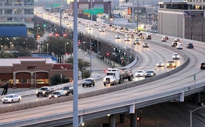 Pending a vote next month by the Texas Transportation Committee, some early-stage projects connected to TxDOT’s plan to reroute I-45 and the whole downtown freeway exchange system could be getting started a few years sooner than TxDOT officials initially thought they would, Dug Begley writes in the Chronicle. (Those early stages include the reworking of the bottleneck on northbound US-59 where Spur 527 now peels off 2 of the freeway’s lanes just before SH 288 merges into the mix.) The first few projects “are incremental compared to the overall plan,” writes Begley, but “officials say [the projects] are important and send the clear message: The I-45 freeway is relocating and the elevated portion along Pierce will be abandoned and maybe demolished within the next dozen years. . . .Work on revamping the freeway intersections is slated for late 2020 or early 2021.” [Houston Chronicle; previously on Swamplot] Photo of Pierce Elevated: Russell Hancock
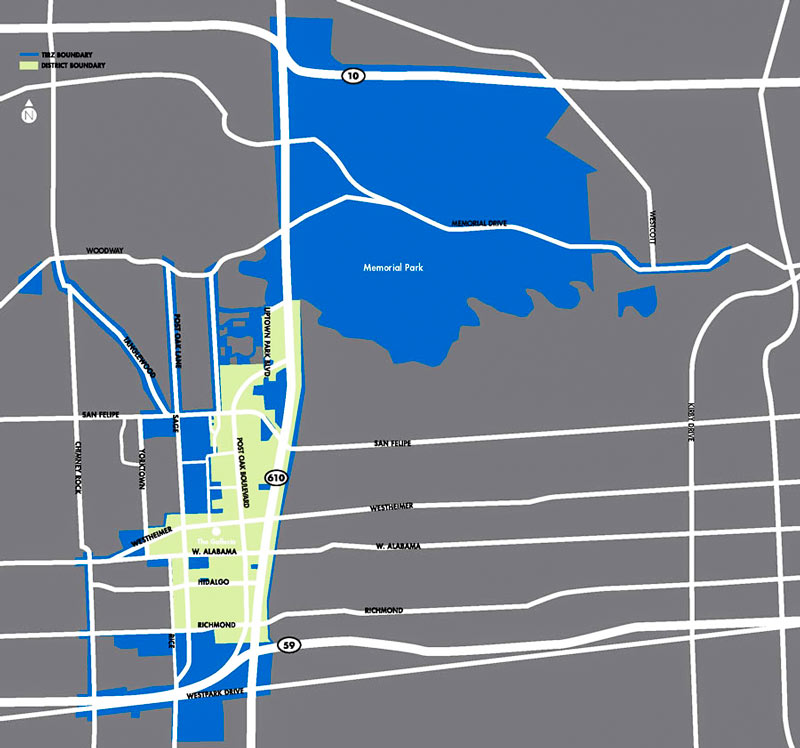
A new lawsuit was filed yesterday against TIRZ 16, the Uptown Development Authority, and the city, alleging that the creation of the reinvestment zone in the Galleria area was in violation of Texas law, since the zone can’t reasonably be considered “unproductive, underdeveloped, or blighted.” Rather, the filing claims, the city ordinance that originally created the TIRZ used the justification that the Uptown area needed traffic decongestion to avoid losing its status as one of the wealthiest districts in the city, and to avoid draining business to the city’s ever-expanding suburban fringe. A hearing is going on today over a possible injunction on further spending or work on Uptown projects, and Mike Morris says that city council delayed a vote yesterday on allowing Uptown an additional $65 million in debt.
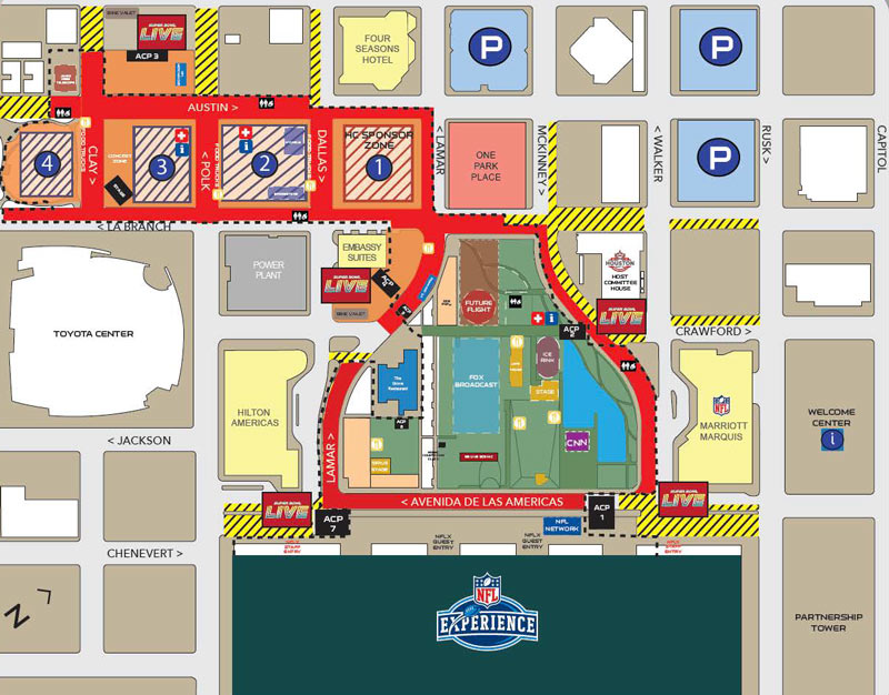
An essential addition to the growing list of guides for Houstonians on where not to go this weekend: the above map of road closures around the George R. Brown Convention Center district. Both red shading and cross-hatching mark the temporary carless zones, while a dashed black line shows the location of the perimeter fence for area events. Meanwhile, miles away at actual Super Bowl location NRG Stadium, other street closures were planned to go into effect yesterday evening (and are scheduled to last through Monday morning):
FINDING CHEAP HOMES AT THE 20 MILE COMMUTER SWEET SPOT 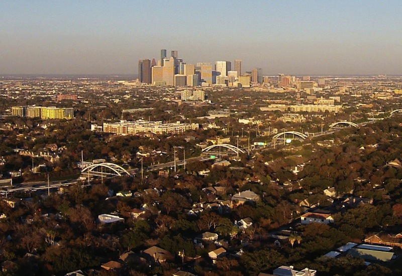 Data type Scott Davis tells Paul Takahashi this week that the average commute distance among Houstonians with a $265,000 home is 30.5 miles, according to his company’s real-estate database. The middle 2 thirds of that price group makes a slog of anywhere between 15 and 47 miles to get to work; Davis says some folks in that range drive as far as 60 miles. He does note to Takahashi, however, that the homes closer in — say, within 15 or 20 miles of a major employment hub — tend to sell much faster; HAR even rolled out a tool last year to allow searches for housing by commute time. [HBJ] Photo: Russell Hancock via Swamplot Flickr Pool
COMMENT OF THE DAY: WHAT’S REALLY STALLING HOUSTON’S DRIVE FOR SMOG REDUCTION  “ . . . The serious ways to improve air quality in Houston are 1) to pass California emission standards for all vehicles, and 2) to install traffic light road sensors at intersections. I can’t believe how long we sit at intersections with no one moving.” [KB, commenting on Building for Baby Boomers; Revamping the Briar Club in Upper Kirby] Illustration: Lulu
Replacement work on the Yale St. bridge over White Oak Bayou now won’t start until the 25th, according to an update from TxDOT. The original planned construction start drifted past in the middle of Monday’s deluge; no changes have been mentioned yet for expected 2018 reopening date.
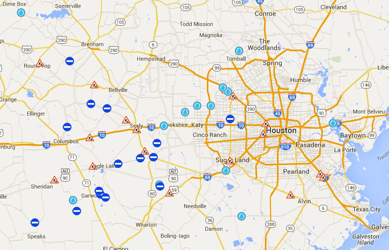
Meanwhile, TxDOT’s Yoakum office says it’s keeping an eye on US 59 in Wharton County to the southwest of town, though that highway is not closed at the moment according to the agency’s interactive mapping system (pictured above). The map shows areas of road closures, flooding, and construction, with written descriptions for each site clarifying which lanes are affected, by what, and how badly. Zooming in further gives a clearer picture of the extent of some of the closures — below is a view of west Houston, showing the stretch of Hwy. 6 near the Addicks reservoir that could be closed for the next 4 to 6 weeks:Â
COMMENT OF THE DAY: HOW TWO WRONGS AND A RIGHT MAKE A FASTER LEFT  “There are ways to speed up intersections which are scientifically proven and sound but rarely implemented. One way to reduce accidents, improve traffic flow, and decrease left turn times is to prohibit left-hand turns altogether. Left-hand turns would be completed by driving through the intersection and making a u-turn before the next intersection, followed by a right-hand turn. The same lanes would flow faster, and more traffic could be carried with no increase in infrastructure. Left turn times are actually decreased by this method, which seems counter-intuitive. Traffic engineers recognize this, but neighborhood activists and politicians frequently oppose it as being inconvenient for drivers. . . .” [Jardinero1, commenting on Comment of the Day: A Different Approach to the Future of Downtown Approaches] Illustration: Lulu
COMMENT OF THE DAY: A DIFFERENT APPROACH TO THE FUTURE OF DOWNTOWN APPROACHES  “An alternative that I would heartily recommend would be to work on nearby crosstown routes that may serve to relieve pressure on downtown-area freeways. Those would also be expensive and controversial, but also they are the low-hanging fruit; for example running a toll facility along the north-south Union Pacific ROW. Or completing SH 35 and then creating individually-tolled grade separations from there up Scott St. or Lockwood. OST is a very good candidate for this, as is the N. Shepard/Durham corridor. Do anything possible to speed up thru-traffic along Bayous by removing signalized intersections, especially along the Braeswoods, the T.C. Jesters, and of course Memorial Dr. and Allen Pkwy. These are all things that we would want to have around later on during the course of construction, anyway — but also, decentralized improvements have the advantage of being less subject to economic obsolescence resulting from…say driverless cars and rideshares…which place a big question mark on the near-term utility of mega-projects that required perhaps a decade to finish.” [TheNiche, commenting on TxDOT’s Plans for Freeway Expansion Around and Below the Newly Protected Cheek-Neal Coffee Building] Illustration: Lulu
COMMENT OF THE DAY: ON THE OTHER SIDE OF THE TRACKS  “The love affair with trains by a certain group of urbanists in the US is a ‘grass is greener on the other side’ mentality; they always point how wonderful public transport is in Europe. Well, if you actually lived in you Europe (and I have for many years), you realize that public transport is a horrible pain in the ass to live with every day. It’s inefficient if you have to go anywhere that is not on direct route, you have to make plans days in advance if you need to be across town at a particular time, you have to go to the market every F-ing day to buy food because you can’t carry more than a couple of bags at a time. You eventually give up after a while and end up confining your life to within a couple of blocks of your house. Don’t even get me started when the weather is bad. There’s one thing everyone in dense European cities dreams of: owning a car.” [commonsense, commenting on Which Came First: the Traffic or the Freeway Lanes?] Illustration: Lulu
COMMENT OF THE DAY: CYCLING THROUGH TRAFFIC JAMS ON THE ROAD TO THE AMERICAN DREAM  “The real crux of the issue here is that Americans are constantly sold on the idea that cars represent ultimate freedom and prosperity. That image breaks down when crowds of commuters start forming giant, slow-moving, panic-inducing trains of automobiles. The cognitive dissonance causes automobilists to latch on to the only solution they can imagine: ‘wider roads will restore that feeling of freedom.’ Of course, it never really works out that way.” [Derek, commenting on Which Came First: the Traffic or the Freeway Lanes?] Illustration: Lulu
WHICH CAME FIRST: THE TRAFFIC OR THE FREEWAY LANES? 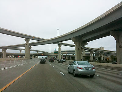 “Population growth doesn’t happen independently of transportation infrastructure—it’s profoundly shaped by it,” writes Daniel Hertz over at City Observatory this week. Hertz’s commentary comes in response to pushback following an article in which the blog weighed the outcome of the Katy Freeway’s 2008 expansion (calling out 30- and 55-percent increases in morning and afternoon commute times between 2011 and 2014). Pro-expansion readers purportedly commented that while travel times along the corridor did actually get worse, those same slowdowns would have been even stickier had the expansion not taken place when it did. But that’s backwards, argues Hertz, or at least a simplification: “In fact, research dating back at least to the 1950s has found over and over that highway construction in the urban periphery is associated with more housing construction there—and the depopulation o[f] urban neighborhoods. . . . Part of the way that highways fill themselves up with cars is by creating demand for housing near them.” [City Observatory, previously on Swamplot] Photo of I-10 West: Andres Lombana [license]

