HARRIS COUNTY GETTING IN ON THE PASADENA REFINERY AIR POLLUTION LAWSUIT ACTION 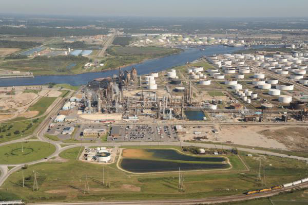 In the wake of the lawsuit the Sierra Club and Environment Texas filed last week alleging that the century-old Pasadena Refining System plant has violated the federal Clean Air Act some thousands of times, Harris County attorney Vince Ryan has filed another suit against the plant.  This one’s to do with the facility allegedly breaking state level environmental laws, Diana Wray writes in this week’s Houston Press; incidents of particular note include last summer’s major sulfur dioxide leak, which briefly shut down both the nearby Washburn Tunnel and the rest of the Ship Channel (while sending Galena Park into duck-and-cover mode). Wray writes that both lawsuits seem mostly geared toward getting the plant to clean up its act; each suit also has the potential to require that some kind of compliance watchdog or overseer be assigned to plant to ensure that it’s doing so. [Houston Press; previously on Swamplot] Photo of Pasadena Refinery Systems, Inc. plant at 111 Red Bluff Rd.: Center for Land Use Interpretation (license)
Tag: Refineries
UNIDENTIFIED CHEMICAL STENCH, HAZE DRIFTING ACROSS TOWN OFFICIALLY NO CAUSE FOR CONCERN  Suggested and mandatory restrictions on hanging around outside were issued by the Memorial Village area’s fire department and by Katy ISD respectively for a while this morning, in response to the acrid odor and haze blowing in some 40 miles across the city from somewhere near the Ship Channel. The Houston emergency response folks say that their monitoring has turned up no air quality red flags, but that anyone who can avoid the stink should probably do so just in case. The particular origin and composition of the odor also still seems to still be up for debate this afternoon: The Albemarle facility at 13000 Bay Park Rd. (shown above) called into the CAER hotline this morning to report that they might be releasing natural gas odorizer throughout the day as their gas facilities got worked on, and LyondellBasell’s Sheldon Rd. facility also sent a message to the CAER line that they would be conducting flaring today in response to a “unit upset,” but no official suspects have been named by the city. The extent of the odor’s inland spread is notably broader than last month’s quickie Valero tank overfill stench incident in Manchester: KHOU reports that some of its viewers on the southeast side of town started calling in about the smell around 10 am, and that “by 11 a.m. the smell and an apparent haze covered most of downtown Houston and the west side, with some reports from as far north as Bush Airport.” [KHOU; previously on Swamplot] Photo of Albemarle facility at 13000 Bay Park Rd.: April R.
WHAT’S SO SPECIAL ABOUT THE PASADENA REFINERY THAT RELEASED 3 MORE TONS OF AIR POLLUTION ON THURSDAY?  “We worry about this plant more than we worry about the others,” Air Alliance Houston director Adrian Shelley tells Dylan Baddour after last week’s release of a 6,000-pound cocktail of toxic air contaminants from the Pasadena Refinery System complex, south of Buffalo Bayou just east of the Washburn Tunnel. The release occurred in the wake of a 7-hour power outage at the Petrobras-owned refinery (which played a role in the massive Brazilian corruption scandal that came to light last year); Baddour says this is the 8th contaminant release the company has reported so far this year (and the 65th since 2005). Shelley notes that the plant has a reputation for “large particulate matter (soot) release events that you really don’t see at other Houston refineries,” including the 2 tons of soot released on Thursday with sulfur dioxide gas and other contaminants; Shelley also notes that one of the plant’s key federal permits expired last year, resulting in a $7000 fine from the TCEQ. [Houston Chronicle; previously on Swamplot] Photo of Pasadena Refinery Systems, Inc. plant at 111 Red Bluff Rd.: Center for Land Use Interpretation (license)
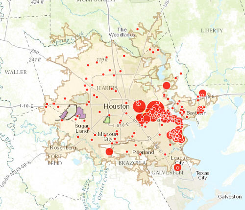
The little and not-so-little red dots on the map above show off sites on the EPA’s list of plants and refineries required to have a Risk Management Plan due to their potential for accidental hazardous chemical releases — with the larger dots showing the places that have already had an accident (or, in some cases, as many as 43). Clicking each dot will tell you what the facility’s name is, as well as how much toxic or flammable material it stores on site (to the nearest thousand pounds or so).
The Union of Concerned Scientists and t.e.j.a.s. put together the interactive map as part of a report released late last week, which compares the EPA’s data on air quality and cancer rates in a few neighborhoods on the west side of town (specifically in Bellaire and in the West Oaks and Eldridge area, just inside Hwy.6 near the Barker reservoir) with the same data in a couple of east side spots (Galena Park and Manchester).
WAIT, DID THE 2008 RECESSION UP THE CHANCES OF A FUTURE HOUSTON CHEMICAL CATASTROPHE? 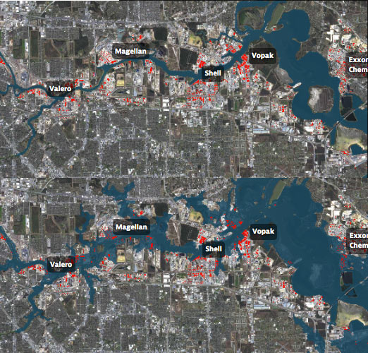 Roy Scranton imagines “a wave of water sweeping toxic waste into playgrounds, shops and houses” in Magnolia Park in his op-ed this morning, written after touring the Ship Channel and speaking with the local A&M and Rice research teams pushing for variations on a series of region-scale coastal barriers to hunker down behind whenever the next gigantic hurricane hits the Houston region, in hopes of avoiding deadly flooding and catastrophic chemical spills. But the researchers tell Scranton that pushing for federal and state funding for a response is a slow endeavor; Jim Blackburn (a main player on the Rice team) tells Scranton that he’s “heard more than one person say our plan is to wait until the next hurricane comes, then depend on guilt money from Washington to fix the problem.” Scranton writes that the best chance for that guilt money so far might have been in 2008, when Hurricane Ike landed just 30 miles northeast of the zone that modelers say could have caused thousands of deaths and irreparable ecological devastation to the area, on September 13th — 2 days before the Lehman Brothers filed for bankruptcy, pulling global attention and national funds to other issues as markets began to crash. [NY Times; previously on Swamplot] Model maps of potential storm surge flooding along the ship channel, with chemical storage marked in red: Texas Tribune
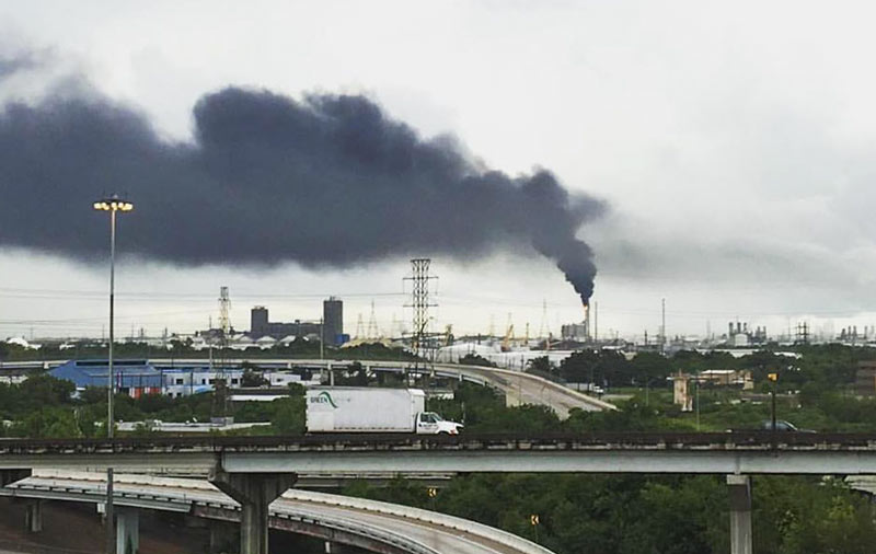
Yesterday’s entry in Houston’s recurring game of what’s-that-mysterious-black-cloud was brought to you by LyondellBasell’s Pasadena refinery at 12000 Lawndale St. (the same one that caught fire back in early April). The shot above was taken from an overpass near the junction of Loop 610 with Hwy. 225, though for parts of the afternoon the trail was visible from at least 7 miles away at the Hilton Americas building downtown. A LyondellBasell spokesperson tells Swamplot that flaring was triggered just before noon after a Calpine facility sending steam to the refinery lost power, reportedly due to a lightning strike. The company sent a message to the East Harris County Manufacturer’s Association’s emergency response info hotline stating that observers “may notice a bright orange flame, black smoke or a rumbling noise,” but that it was no big deal, and no one in nextdoor Manchester or Deer Park needed to do anything like leave or tape their windows shut this time.
- Previously on Swamplot:Â This Morning’s LyondellBasell Refinery Fire Put Out 19 Hours after Yesterday’s ExxonMobil Refinery Fire
Photo: Michael Muguerza via t.e.j.a.s.
COMMENT OF THE DAY: BOTH OPTIONS FOR DEALING WITH RUN-OF-THE-MILL HOUSTON TOXICITY  “My wife, until last May, worked at a school very close to this (but [which] was not mentioned). The air pollution on normal days is so bad that my wife’s doctor suggested that if we wanted to have children that she should think about changing jobs.  . . .  Attention is only drawn to the problem when major events happen — but perhaps long term effects of living and working in the area are greater ([and] simply tolerated as business as usual). I have said it before, but it is worth mentioning: I called the TCEQ and many agencies during my wife’s time working over there about the pollution . . .  they informed me that the area has regularly violated EPA standards and my only option was to ‘vote for people who care about government regulation’ of said pollution. Sounds like a tough project!” [Anon, commenting on This Morning’s LyondellBasell Refinery Fire Put Out 19 Hours after Yesterday’s ExxonMobil Refinery Fire] Illustration: Lulu
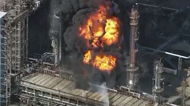
News choppers milling around the LyondellBasell refinery at 12000 Lawndale St. this morning, just west of the 610 bridge over the Ship Channel, caught some shots of billowing black smoke and flames at the facility, which have since been put out. The company reports that heavy fuel oil and cleaning fluids burned after a Coker unit caught fire around 10AM for reasons yet unknown.  The Houston fire department suggested until about 11:15 that folks please stay indoors and try not to let in any fumes in nextdoor Manchester, as well as south and west as far as Park Place Blvd. and Broadway St.; students at nearby Chavez High, Deady Middle School, and Rucker Elementary were also included in the shelter-in-place fun.
After burning for about 2 hours, the fire was put out just before noon — not nearly as speedily as yesterday’s fire at the ExxonMobil refinery in Baytown, which started around 4:40PM and was out by just after 5. That fire’s cause is also unknown; no injuries were reported in either incident.

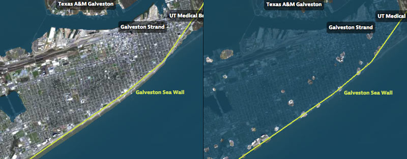
That’s Galveston Island going for a dip in the before-and-after captures above, from a set of interactive timelapse maps released by the Texas Tribune and ProPublica yesterday (along with several articles by authors Kiah Collier and Neena Satija). The new maps model flooding across the Houston region during Hurricane Ike — as well as what would have happened if Ike had actually hit just south of Houston, as meteorologists initially expected.
The maps are your chance to relive an old disaster, or to see how many of your neighbors you can take out with a hypothetical-but-not-unrealistic future storm: users can pick between Ike, south-er Ike, a storm 15% stronger than Ike (nicknamed Mighty Ike), and a modeled 500-year storm (which the article suggests may actually be a concern on the every-few-decades-or-so level; ‘500-year’ has always meant ‘a low probability in any year’, and climate change is shaking up old modeling assumptions). The graphics also include a few dramatic face-offs:Â Mighty Ike and the 500-year storm VS. 2 of the miles-long multi-billion-dollar coastal protection projects being studied for the upper Texas coast.
You can even search for your home address in the map system to see what flood levels might look like in your own back yard. Here’s what the maps show happening to the Clear Lake, Seabrook, and League City areas at the peak of the 500-year storm model’s storm surge, which the article says is a “not if, but when” event:
COMMENT OF THE DAY: SIZING UP HOUSTON’S REFINERY BOOM  ” . . . The total investment ongoing in the Petrochemical complex is about $50 billion. 1000 Main sold in 2014 (after the crash was underway) for $0.5 billion. There are about 50 skyscrapers in downtown. Therefore, with the investment ongoing in the Petro complex, we could rebuild downtown Houston twice with only our classiest of class A skyscrapers.” [awp, commenting on A Tale of 2 Houstons During the Oil Bust; Inside 500 Crawford] Illustration: Lulu
COMMENT OF THE DAY: LIKE THE BAYOUS, HOUSTON OIL DEVELOPMENT FLOWS WEST TO EAST  “. . . First, low oil prices are absolutely TERRIBLE for upstream (Schlumberger, Baker Hughes, Fluor, etc). However, it’s not necessarily terrible for downstream. Expensive or cheap, oil has to be refined and there has been no reduction in the demand of downstream products (gas, polymers, aromatics etc). If you know the Houston energy market then you know that Upstream is located heavily in Katy and Sugarland. Downstream is located primarily on the East Side of Houston, with some exceptions (like the EM woodlands campus). More central or (to a degree) eastern housing markets should still see significant demand.
Second, understand that some oil companies move very slowly. Capital expense budgets are planned years in advance. Those don’t necessarily just get ripped up and thrown out the window just because the price of oil has tanked. Yet again, UPSTREAM is definitely cancelling capital left and right, I mean only a moron would drill a new low margin well right now, but Downstream? I believe at least 2 new crackers are coming online this year and a new 500+ kta polymer reactor is as well. Those aren’t stopping, and low oil prices wouldn’t stop them anyways.” [MrEction, commenting on Downtown Foreclosure Auctions in Their Final Year; Bramble’s Debut; Krispy Kreme’s Opening Date] Illustration: Lulu
COMMENT OF THE DAY: WHY IS ANYONE LIVING THAT CLOSE TO A REFINERY?  “Tax policy should probably discourage residential habitation in neighborhoods near the Houston Ship Channel and encourage people to move away from them. As such, giving existing residents or residential property owners a tax cut in order to reward them for residing there or maintaining and leasing housing to other people would be extraordinarily counterproductive and stupid.
Manchester in particular is a neighborhood where the City or State government should seriously consider its options with respect to eminent domain. There’s nothing quite like it anywhere else in the region. Even the furthest north residential bits and pieces of Pasadena are better isolated from refinery activities and more integrated into their city than is Manchester.” [TheNiche, commenting on Baytown Buc-ee’s Is Here; Goodbye Mission Burrito, Hello Ãœberrito Mexican Grill] Illustration: Lulu
Raw helicopter footage from abc13 of the fire currently raging at the Enterprise Products natural gas fractionation facility at 135 Sun Oil Rd., just east of Hwy. 146 in Mont Belvieu. By 3:55 in, the view gets better, and you can hear the commentator noting that the fire was visible from above Hobby Airport, just 30 miles away.
- Explosion, fire burning at Mont Belvieu facility [abc13]
- Plant burns in Mont Belvieu [Houston Chronicle]
Video: abc13
RAINY DAYS AND SUNDAYS ALWAYS GET ME DOWN “So it stinks like something awful again where I am today (the Heights). I look at the calendar and realize it’s been 2 prime dump days in a row, a wet Sunday followed by a national holiday. An old friend of mine who grew up on the east side used to say that a Sunday when it rained was the perfect day for all the refineries to release their nastiest emissions, because the rain masked it and for some reason there wasn’t any enforcement on the weekend. I’m wondering where else in the city it smells like what I’m smelling, and is there any truth to the rainy-day-dump theory? That’s some strong anecdotal evidence in my nostrils.” [Swamplot inbox]
THE LUNCHTIME RACKET AT BRADY’S LANDING Visiting the Houston Ship Channel on a promotional “toxic tour” of sites where the air will likely be invigorated once nearby refineries get chugging on the Canadian tar sands headed for Houston through the proposed Keystone XL pipeline, Perry Dorrell stops by the scenic Brady’s Landing Restaurant during lunchtime: “During the evening the restaurant is like many others in the city: bustling with patrons and staff, the parking lot busy with diner traffic. During the day, however, the region’s oppressive noise is invasive and obnoxious; right next door a facility is dry-docking barges and a team of several men operating industrial-grade pressure washers removes barnacles from their hulls. Cranes swing containers to and from foreign freighters, crashing and booming. The warehouses directly across the channel are beehives of activity, with stevedores operating forklifts, shifting and stacking and slamming pallets of material. It was amazing how loud it was, a phenomenon I never noticed in my visits at night to dine. On the other side of the restaurant a steamshovel was loading and unloading a smoking, 200-hundred-foot high brown pile of … something, fertilizer-like in appearance. No accompanying aroma, fortunately. Maybe we were upwind.” [Brains and Eggs; previously on Swamplot]

