YOU’RE STILL ON CORNER CAMERA Red-light cameras “continue to monitor intersections,” says Mayor Parker — even though no traffic tickets from the machines are currently being issued. Her comments came in response to a ruling this morning by U.S. District Judge Lynn Hughes that declared last November’s referendum ending the red-light-camera program invalid. The city charter limits the time during which a city ordinance may be repealed; according to Judge Hughes’s ruling, the referendum simply came too late. “Enforcing traffic signals by cameras may be good policy, or it may be bad policy. . . . The court simply must enforce the rules for making policy choices by charter amendment or referendum,” the Judge writes. “Those who favor repeal will react that this distinction is a legal technicality. In some sense, all law is a technicality.” [Office of the Mayor; ruling (PDF); more info; previously on Swamplot]
Tag: Traffic
COMMENT OF THE DAY: THE HUNG BROWSER DEFENSE “I don’t believe that I did [run the red light]. And the alleged video that claimed to show my car going through the light never worked for me, as I never could get the video to load.” [Random Poster, commenting on Red Light Cameras No Longer Recording]
RED LIGHT CAMERAS NO LONGER RECORDING As of 10 this morning, all 70 traffic-intersection cameras have been turned off. Proposition 3, which would have allowed the cameras to continue to snap photos of red-light runners, was defeated by Houston voters 2 weeks ago. “City officials said they have $25 million in uncollected fines from citations that were issued. [Mayor] Parker said the city plans to aggressively go after those violators. City officials have not said when the cameras will be removed from the intersections.” [Click2Houston]
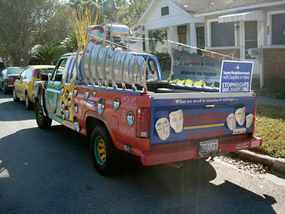
How many cars showed up? “If Steven Colbert can get away with 6 Billion on The Mall, we can call this 22,000…what’s in a number?” asks a reader who says there were actually probably 70 to 100 cars lined up at about 10:15 at last Saturday’s traffic-themed protest of the planned West End Walmart. Comments sent to Swamplot yesterday:
We made the scene at 18th & Rutland during preparation for what one organizer described as a “Flash Mob sort of thingâ€. . . . The mood was fairly lighthearted; it was a beautiful morning after all. Plan was to drive down and around the Koehler Street site and make general mischief, I guess. Saw one TV station camera crew, but did not see anything in print over the next couple of days. Admittedly, I didn’t look real hard.
While I don’t agree with these folks . . . I have to admit, I honor their activism.
“What we need is sustained outrageâ€, indeed!
- Walmart CARNAGE Protest [Stop Heights Walmart]
- Protesters Hit The Streets To Stop The Heights WalMart [39 Online]
- Heights Walmart critics use ‘mobile protest’ to demonstrate traffic impact [11 News]
- West End Walmart coverage [Swamplot]
Photo: Swamplot inbox
WEST END WALMART DEVELOPMENT GETS ITS KOEHLER ST. JOG Despite the protests of a number of speakers — including council member Ed Gonzalez — who wanted some study of neighborhood traffic to be conducted first, the planning commission yesterday approved a minor variance connected with the West End Walmart yesterday, after 2 earlier postponements. The variance allows Koehler St. to be extended from Yale St. to Heights Blvd., even though the resulting street alignment doesn’t meet city development standards. [HTV; previously on Swamplot]
SUGAR LAND EXPERIMENTS WITH FLASHING YELLOW ARROWS Coming soon: the greater Houston area’s first-ever flashing yellow arrow left-turn traffic lights, in 5 signals around the Sugar Land Business Park near West Airport Blvd. and Dairy Ashford! Will you know how to handle them? “The flashing yellow ‘instinctively implies caution,’ which is the preferred reaction when drivers make judgment calls about turning left into a gap in traffic, said city officials. . . . When approaching the intersection, a solid red arrow indicates a required stop – left turning drivers must stop. Drivers must also stop at a solid yellow arrow. A flashing yellow arrow requires motorists to first yield to oncoming traffic and pedestrians before proceeding to turn left. A solid green arrow permits drivers to turn left while oncoming traffic stops. . . . ‘We’ve targeted these initial intersections as part of a phased approach intended to allow residents to become familiar with FYAs [flashing yellow arrows] before utilizing the lights in more densely travelled areas,’ said Assistant Public Works Director David Worley. ‘Our selection of the Business Park will give us the opportunity to refine the timing and ensure education of our motorists.’ Following a six-month study period, the FYAs will be considered for implementation along Eldridge Road, a major north-south corridor through Sugar Land. In addition, a policy will be developed that specifies a process for selection of future intersections.” [Fort Bend Now]
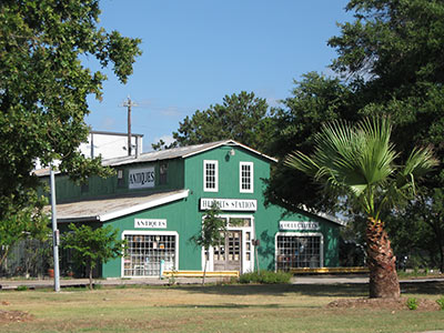
Several retail outlets near the railroad tracks at the base of Heights Blvd. near Center St. are complaining that traffic changes accompanying the new Washington Ave. quiet zone have already hurt their businesses. Department of Public Works spokesperson Alvin Wright tells Channel 39’s Jason Volentine that Federal Railroad Administration requirements mandate that crossovers through the Heights Blvd. median near the tracks be closed off for the quiet zone to be implemented.
Without a quiet zone, train conductors are required to blast their horns at all at-grade crossings. The Washington quiet zone will extend from Sherwin St. north of I-10, to National, about a quarter-mile east of Studewood:
THE ALLEN PARKWAY SPEED TRAP  “Traffic accidents increased 47 percent and injuries 154 percent on Allen Parkway last year even as the number of motorists ticketed for speeding continued a lengthy and significant decline on the near-downtown roadway, according to police and municipal court records. . . .
Houston police, who were unaware of the drop in speeding tickets until asked by the Houston Chronicle and were at a loss to explain them, said they will begin a weeklong study today of motorists’ speeds on Allen Parkway. If high rates of speeding are detected, an enforcement blitz with radar units will begin, said Capt. Carl Driskell, who heads HPD’s traffic enforcement division.” [Houston Chronicle] Photo: Flickr user Lee Ann L.
HAZARDS OF THE WEST LOOP Except for a memorable afternoon of standstill traffic — and the maybe 1,500 gallons of gasoline that made their way through storm sewers to Galveston Bay — no major disaster resulted from that tanker spill 2 Fridays ago on Bellaire Blvd. below the West Loop. That’s better than the last time: “[L]ongtime residents of the area remember an incident in May 1976 when a truck carrying anhydrous ammonia slammed into a bridge railing on the connector from the West Loop to the southbound Southwest Freeway and fell onto the freeway below. Of those within 1,000 feet of the spill, six people died, 78 suffered serious injuries and 100 more were treated for their exposure. That tragedy played out only about a mile from the site of Friday’s accident. Thirty-four years after that terrible day, nothing has changed. The poorly engineered West Loop, as it approaches the 59, is one of the worst sites for accidents in the U.S. — yet it is also designated pathway for some of the most hazardous cargo in the world. More is transported on the vulnerable tracks that run through southwest Houston, divide West University and Bellaire, skirt along Afton Oaks, River Oaks and Memorial Park.” [West University Examiner]
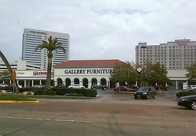
At a meeting last week at Kenny & Ziggy’s Deli organized by Jim “Mattress Mack” MacIngvale, owners of businesses located along Post Oak Blvd.’s vast double phalanx of front-loading strip centers — and representatives of a few of their landlords — groused about Metro’s design for the new Uptown Line and prepared for possible battle. The Examiner Newspapers’ Michael Reed first brought attention to a few quirks of the latest design for the Post Oak stretch of the light-rail line late last year: It features 7 stations, 5 gated crossings, and in all close to 2 dozen traffic signals along the 1.7-mile path from Richmond Ave. to the 610 West Loop. It also blocks all instances of that staple of sprawl-style shopping-center development: the non-intersection left turn.
Had Metro been communicating its plans to the property owners? Had the property owners been relaying any information they received from the transit agency to their tenants?
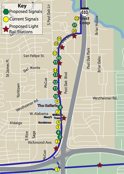
Once the new Metro Uptown light-rail line is built, Post Oak Blvd. could feature more than 23 stoplights along its 1.7-mile stretch between Richmond Ave. and the 610 Loop, reports the River Oaks Examiner‘s Mike Reed. A report prepared last October by the group of companies contracted to build the new Uptown Line lists 21 stoplights and 7 stations.
But that information’s got to be out of date, right?
. . . in response to questions, a Metropolitan Transit Authority spokeswoman said Tuesday that since the report was written, the number of potential signals has increased to 23, with an additional traffic light and an additional pedestrian light under consideration.
While the proposals contained in such reports are subject to change, the original document indicates the scope of the project combined with the density and development in the area would make substantial alterations to the plan difficult at best.
Reed also reports a few details on the rebuilding of Post Oak:
COMMENT OF THE DAY: WHERE THE SKYSCRAPERS WILL BE BUILT “. . . in a century or two, Houston will be very densely populated. . . . I think Houston is relatively lucky to have street grids across most parts of the city, as opposed to the suburban lollipops in, say, Pearland’s newer subdivisions. When the skyscrapers come — and they will — then Houston’s grids will handle the load better than the lollipops would; and if worse comes to worse, old blocks can be razed for new streets, or our existing streets can be turned into one-way, so that for example you might have Bellaire and Westheimer only go westbound, and Richmond and San Felipe only eastbound (or vice versa).” [J.V., commenting on City to Ashby Highrise: Yes You Can!]
COMMENT OF THE DAY: AFTER THE ASHBY HIGHRISE “. . . My take on it is that this building MIGHT NOT be too bad, once the teeth-on-edge construction period is finished. (And I seem to be the only person who thinks the construction hassles should even matter to anyone. Big crane delivery and setup on Bissonnet, anyone?) But since there seems to be no legal way to stop this one, you can be sure that there will be some serious efforts to put rules in place to prevent any more. My own tongue-in-cheek explanation for why the neighborhood was so taken by surprise is that no-one ever thought for a minute that it made any kind of sense to build a high-rise on Bissonnet, for goodness sake.” [marmer, commenting on City to Ashby Highrise: Yes You Can!]
Note: Story updated below.
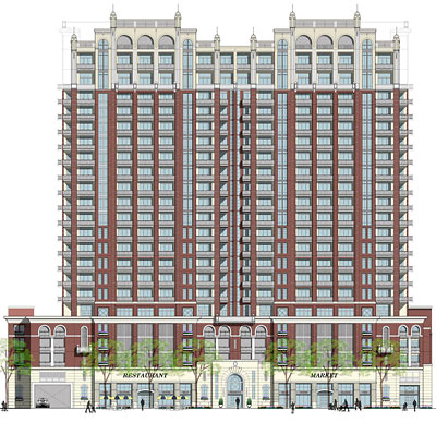
The 11th time’s the charm! According to Abc13 reporter Miya Shay, the city today gave the developers of the Ashby Highrise the final approval they needed to begin construction of the 23-story residential tower at the corner of Ashby and Bissonnet, next to Southampton.
Okay now everybody, show us your cards!
Update, 5:49 p.m.: Some details about why the most recent plans were approved, from a city news release via the River Oaks Examiner:
COMMENT OF THE DAY: MEMORIAL HIGHWAY “I really like the memorials constructed at ‘death-sites’ along roadways: They honor the deceased and alert us to risks, causing us to reflect on how easy it is to die in traffic accidents. I first saw this memorial custom on Grand Cayman Island where signs were erected at the sites of traffic fatalities. Years ago there were only a few, and, the twisted, rusty car wreckages were left in-situ as well. It was vivid and effective: Like performance-art really; Printed in white on the circular, black signs: ‘Accident Black Spot.’” [movocelot, commenting on Comment of the Day: What To Expect on That First Night in Your New Funeral Home]

