MORE PONDS, HUGGING BAYOUS Houston will spend $30 million in the upcoming fiscal year on detention ponds like those built under Project Brays. “About $20 million in federal Hurricane Ike relief money and $10 million in city capital improvements funding will be used to buy land and design and build basins that can hold hundreds of acre feet of water when the bayous become full, [Mayor] White said. City officials are evaluating sites along the Hunting, Greens, White Oak, and Halls bayous for new detention basins, said Andy Icken, deputy director of the Public Works and Engineering Department.” [Houston Chronicle]
Flooding
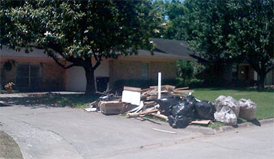
Some residents of Long Point Woods are blaming the new and well-paved 48-acre Village Plaza at Bunker Hill shopping center along the north feeder road of the expanded Katy Freeway for the late-April flooding that damaged many homes between Bunker Hill Rd. and Blalock, south of Westview. Abc13’s Miya Shay reports, opting not to mention the neighborhood or the development by name:
[Resident Barbara] Hunt says homeowners grew worried when a large development along I-10 and Bunker Hill [was] allowed to be built without additional retention, and when heavy rain fell, it ran off the parking lots and into their homes. . . .
But Mayor White says the developers didn’t get special treatment because the property was already covered in asphalt before the developers bought the land and began building.
“If something is built, and somebody buys it from somebody where it already has some paved over and is already developed, we don’t have new detention requirements,” said Mayor White.
OFFICIAL FLOOD TALLY Storms in late April resulted in the flooding of 2,300 homes — the second-highest area total since Tropical Storm Allison hit in 2001. “The figure includes about 1,350 residences in Houston, 800 in unincorporated Harris County and the rest in other towns and cities within the county, said Heather Saucier, a spokeswoman for the county flood control district. More than half of the flooded houses were not in a mapped flood plain, a reminder that every property owner in Houston and Harris County is at risk for flooding and should purchase flood insurance, Saucier said.” [Houston Chronicle; previously on Swamplot]
FLOODING REPORT FROM THE NORTHWEST HOUSTON PRAIRIE BOWL The worst flooding damage from those late April storms centered around a swath of Highway 6 stretching from the Katy Freeway to 290 in northwest Houston. The heaviest rainfall was centered further west, along the planned path of the Grand Parkway Segment E. “[Jennifer] Bayles said her section of Bear Creek Village wasn’t within the 100-year flood plain when she and her husband bought their house 17 years ago. But it was added to the flood plain in new maps developed after Tropical Storm Allison in 2001, and the couple purchased flood insurance despite the steep premiums. ‘We’re well-insured; we’ll be fine,’ she said, but some neighbors don’t have the coverage they need. And their recovery efforts grew more complicated when they learned that if their homes sustained sufficient damage they would have to elevate when they rebuild. In the past few years, Bayles said, her street has flooded regularly during heavy rains, stranding residents in their homes for hours. But the April thunderstorms were the first time she’s had water in her house, she said.” [Houston Chronicle]
BRIDGELAND OVER THE FLOODWATERS Last week’s flooding in northwest Harris County provided only a taste of the problems likely to stem from development in the Katy Prairie along segment E of the planned Grand Parkway, say supporters of a Sierra Club challenge to existing floodplain maps in the Cypress Creek watershed. “An executive of Bridgeland GP, the company developing the 11,400-acre community, said in a Jan. 9, 2008, affidavit that the revisions sought by the Sierra Club would cost the company $28 million in flood mitigation measures that would ‘adversely affect’ the development. Despite the company’s efforts, the maps are being redrawn under U.S. District Judge Lee H. Rosenthal’s supervision. Rosenthal has stayed the lawsuit until October to allow time to complete the maps, but officials said they aren’t certain when the task will be finished. Preliminary revised maps [(PDF)] shown to the Houston Chronicle by [Sierra Club attorney Jim] Blackburn and the Harris County Flood Control District show a significant expansion of the flood plain in an undeveloped western segment of Bridgeland’s property and a reduction of the flood plain in other areas. . . . Asked if Bridgeland could assure Harris County residents that its development won’t worsen future flooding downstream, [Bridgeland VP of Sales] Houghton said, ‘I would have no problem guaranteeing that.'” [Houston Chronicle]
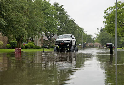
To start our latest installment of fun pix from around town, Jay Lee snaps scenes from this week’s flooding — in a neighborhood near Kirkwood and Briar Forest.
Oh, but there’s more!
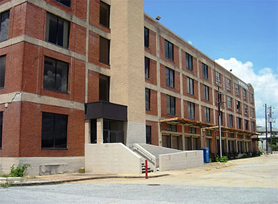
This 1923 former rice warehouse at the far eastern end of Washington Ave., used more recently as an annex for the Downtown post office on the other side of I-45, will become the city’s new permit office, reports Monica Perin in the Houston Business Journal. The building will replace the current 2-story office at 3300 Main St. in Midtown — which Public Works officials consider flood-prone — and consolidate permit offices from 3 other sites.
A LEED-certified renovation of the 4-story concrete-and-brick building, which sits on a 2 1/2-acre site Downtown — and which sat on the market for several years — is expected to be complete by the fall of 2010.
The property purchase is expected to close in July, along with council approval of a contract with Trammell Crow Co. as the developer, and Studio Red Architects as the design firm. . . .
“A building of this age and being a warehouse is relatively easy to recycle,†[Studio Red’s Bill Neuhaus] notes. “It lends itself to an open plan and lots of daylight. We can do an economical job here, and it will be an extremely pleasant working environment.â€
Permitting offices eventually will share space with the city’s new Green Resource Center, which is opening this week at 3300 Main St.
“The re-use of existing buildings is one of the greenest and most sustainable things we can do,†Neuhaus says.
He says the building’s prime location is part of the civic campus, next to the police department, the post office and rail station.
- City permits going green in rice warehouse [Houston Business Journal]
- 1002 Washington [LoopNet]
Photo of 1002 Washington Ave.: LoopNet
COMMENT OF THE DAY: THE BATTLE OF BUNKER HILL VILLAGE “Sounds like the high ground is still important to British occupation.” [Neil, commenting on Outlines of a Bunker Hill Village Theme Retreat]
COMMENT OF THE DAY: BURIED LANDSCAPES OF THE HOUSTON HEIGHTS “Before developers established the heights and its various neighboring subdivisions, a massive filling project took placed. It was pretty much a landfill for the City of Houston. . . . Developer clear cut the existing pine forest (the oaks pretty much only existed near the bayous and tribs) and filled in the uneven landscape. A big example is in Woodland Heights. A 60-inch storm sewer line runs in an old trib to White Oak Bayou. The line is 20-ft below the current natural ground in the area. After the line was built, the natural channel was filled in and streets placed on top. The line currently goes under many people properties and houses and many don’t know it exists. . . . Outside of that, several ox bows and other trib were filled in. A couple were not though. There is one just east of TC jester where it cross White Oak Bayou south of 11th. It has water in it. There is another just west of Yale that is dry. I’ve seen historic photos showing people jumping off the banks of the the natural streams in the bayous in the Clark Pines area (14th street west of Durham). A current development is actually being build on an undeveloped piece of land that was a site of the landfill in this oxbow. The houses are being placed on piles driven deep into the ground to avoid them from sinking or collapsing. I doubt they are telling the home buyers this. Long time residents know about it though.” [kjb434, commenting on Wet and Wild: Strip Redo on White Oak]
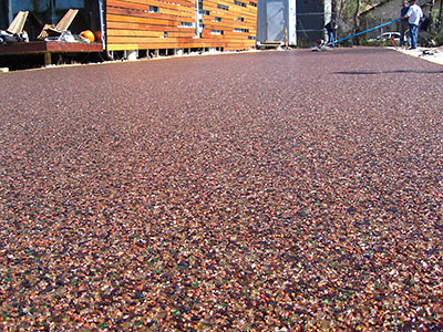
Next experiment at that Swamplot-Award-winning house built out of shipping containers on Cordell St. in Brookesmith? The unique driveway installed earlier this week. John Walker of Numen Development writes in with details:
It is composed of recycled crushed glass, with a resin binder, and achieves the consistency of caramel popcorn for lack of a better description, so it has voids that allow surface water to percolate through the paving and ultimately be absorbed into the underlying soil rather than running off into the storm drainage system. It is a triple threat: recycled material, reduces environmental impact of development, and it’s really cool!
Walker says Presto Geosystems, a division of Alcoa, installed the driveway as a pilot project for the Houston market.
This installation has been described by their consulting engineer as most likely the “first and last” residential project they will do in Houston as the product is expected to meet with huge commercial demand, especially for “landlocked” developments for whom expansion is limited by Harris County stormwater detention limitations.
Some views of the installation:
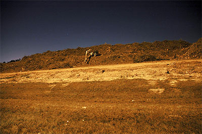
 The high point of River Oaks Examiner reporter Rusty Graham’s tour of Project Brays, where flood control is measured in Astrodomes: sheep — on an actual hill — overlooking Brays Bayou flood-reduction projects at the Eldridge Road basin.
The group arrives at the Eldridge detention basin, at the end of Westpark. Harris County Precinct 3 is developing Archbishop Joseph A. Fiorenza Park at the facility, which is about 45 percent complete.
Eldridge is the largest of the four basins, with a total area of 337 acres. Eldridge will hold 1.5 billion gallons of stormwater when complete, or nearly three Astrodomes.
One of the highlights of the trip is seeing the sheep on a large hill on the west side of the Eldridge basin. The 60-foot hill is built from dirt excavated on site.
The sheep lived in the area before the site was purchased, says Heather Saucier, spokeswoman for the flood district. They’re tended by an area resident, although on this day they seem to be doing well enough on their own.
The hill’s summit offers a commanding view of the area, and is especially impressive looking back towards the Uptown area to the east.
- Down on the bayou: Massive project to reduce flooding [River Oaks Examiner]
- Brays Bayou Project Locations [Project Brays]
Photo: River Oaks Examiner
PAY NO ATTENTION TO THE BAYOU Lisa Gray gets a glimpse of the “chai-colored” waters of Berry Bayou behind her 1966-model Meadowcreek home: “Most of the new houses sprouting in the neighborhood did their level best to ignore the bayou. Most of them still do; it’s rarely a selling point. A year ago, I was delighted to find that not only was it possible to buy a non-flooding bayou house for $150K, but that it might not cost any more than a similar three-bedroom house on a neighboring suburban lot. On har.com’s real estate listings, bayou frontage either went unmentioned or hid under the faint praise ‘no backyard neighbors’ — the same thing sellers say when a house backs up to train tracks. When first looking at the house I now live in, I had to stand on an overturned bucket to see over the privacy fence and down to the water.” [Houston Chronicle]
An awful stench has been wafting through the homes of Golden Glade Estates, just west of Hobby Airport and south of Sims Bayou. There’s also been backyard flooding after every rain, a constant din from trucks, and generator-powered lighting beaming into local Living Rooms during the night. The cause? Huge piles of wood debris, brought into the southeast Houston neighborhood after Hurricane Ike:
Their problems started when Federal Emergency Management Agency contractors began trucking in hundreds of semi truckloads of pungent smelling, steaming mulch. Local 2 Investigates cameras and Sky 2 helicopter footage show some mounds stacked taller than nearby homes, covering acres of land less than 100 yards from some homes.
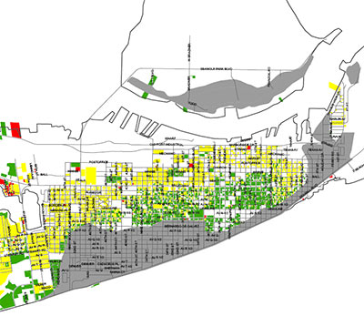
FEMA-approved colors liven up this property-damage-assessment map for 24,000 structures in Galveston.
The red areas are “unsafe; leaning; structurally unsound; completely destroyed; collapsed or structure missing.”
Yellow means “general interior flooding; wind damage; or significantly damaged, but repairable.”
And green means go! “No damage or only minor damage; or missing siding; shingles; handrails; breakaway walls.”
The gray areas? “Flood zone.”
More colorful maps of other Hurricane-Ike-hit areas of the city are available on the City of Galveston website.
- Damage Assessment Map for Areas 61st Street East, 61st Street West to Jamaica Beach, and Jamaica Beach West to San Luis Pass as of 10/15/08 [City of Galveston, via Hair Balls]
- City Releases Damage Assessment Map & Issues Guidance for Property Owners [City of Galveston]
THE FINANCIAL CRISIS: KINDA LIKE FLOODING IN MEYERLAND A rising tide sinks all prices! “When Dr. Mahmoud Amin El-Gamal, chairman of the Rice economics department, is asked — as he has often been in recent days — ‘What’s is going on with our financial institutions?’ he likes to begin his answer with an analogy of local origin. ‘It’s a lot like in the 1980s when the flooding in Meyerland caused the price of all the houses in the area to go down,’ he said, ‘even those houses that did not flood.’ El-Gamal said the same can be said of mortgage securities, many of which were ‘perfectly fine,’ but had been grouped with debts that would likely continue to go unpaid.” [West University Examiner]

