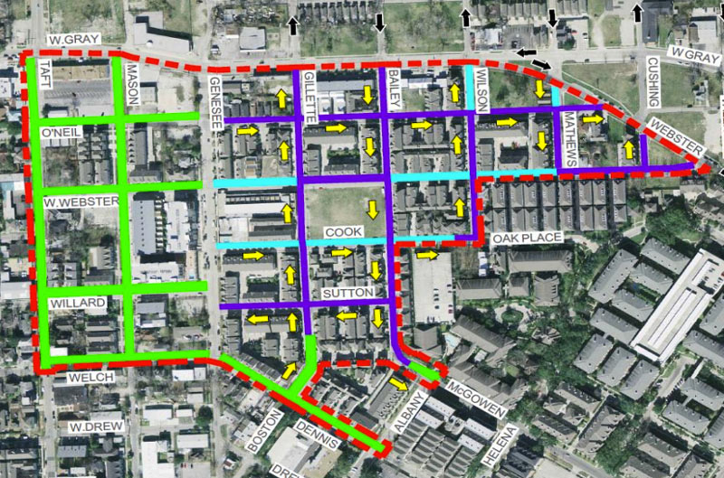
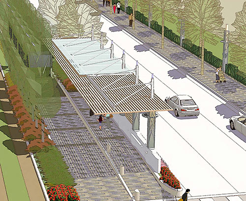
The presentation slides from last week’s meeting about the street and infrastructure work planned for Fourth Ward between W. Gray and Welch streets are now online — you have until May 6th to email the city about it, if you feel like doing so. The green lines show areas where 50-ft.-plus cross-sections are planned, with anywhere from 7 to 22 ft. of pedestrian space (mostly running 12-to-17 ft., in the not-to-scale drawings). Streets marked in light blue would range from 33 to 36 ft. wide, including only 1 sidewalk and a 2-ft. easement on the opposite side; areas marked in dark purple would also get 1 sidewalk, but both vehicle and pedestrian lanes would be several feet narrower (27 to 30 ft. in total).
The work skirts the southern edge of the not-quite-rectangular Freedmen’s Town National Historic District, which runs north-to-south roughly from W. Gray to W. Dallas St., and east-to-west from Gennessee St. as far west as Arthur St. in some places. Planned street and infrastructure work in that area is currently on hold due to the ongoing court case over preserving the remnants of brick roadways in the district, along parts of Wilson and Andrews streets.Â

 “I don’t understand why people want to bury the Pierce Elevated. That seems like something to put onto the table after all the murders are solved and money starts to rain down from the sky. Can someone explain this to me? How could it possibly be practical to tear down this road?” [


 “My wife, until last May, worked at a school very close to


 Former ABC13 investigative reporter Wayne Dolcefino, representing residents of the Cosmopolitan condo tower on Post Oak Blvd., filed a criminal complaint with the Harris County district attorney last week over the way the Uptown Development Authority has gone about acquiring land for the


