04/17/15 11:00am

Johnny Steele Dog Park After Heavy Rains, Buffalo Bayou Park, Houston

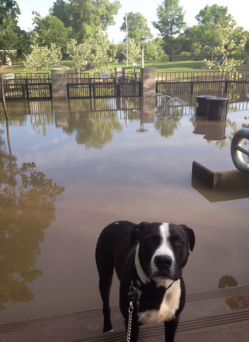
No Buffalo Bayou Park fun this morning for Swamplot coverdog Kep, on account of the whole Johnny Steele Dog Park at the intersection of Studemont and Allen Pkwy. is flooded after yesterday’s downpours. Which is what a bayou-side park is expected to do during and after weather like yesterday’s.

More pics of the scene:

CONTINUE READING THIS STORY

When Buffalo Bayou Spreads
02/19/15 3:30pm

COMMENT OF THE DAY: BEFORE WE EVEN GET AROUND TO A BULLET TRAIN Jacked Up House“This train is needed and do-able, and I bet there are federal funds all up in it . . . However, shouldn’t Houston be moved to higher ground first — before making the long-term commitment?” [movocelot, commenting on Possible Station Locations for Houston-to-Dallas High-Speed Rail: Jersey Village, Mangum Manor, Downtown?] Illustration: Lulu

04/09/14 1:15pm

COMMENT OF THE DAY: THAT SINKING FEELING Flooded Houses“At 13 seconds in, those houses across the water at the top of the frame are at the end of my street, South Burnett Drive, in the Lakewood subdivision. The street rises gradually as you travel away from the water, but the low end of the street lost over 20 houses during Hurricane Ike. Some owners have rebuilt on pilings, some have rebuilt at grade, and others have abandoned the property. (My own house is further up the street, at about 31 feet elevation.) The end of the flood debris field from Ike was about three lots south of my house. So, while the name ‘Swamplot’ is amusing, to some of us it is no joke.” [Reeseman, commenting on Flying High Over the Baytown Subdivision That Sunk] Illustration: Lulu

04/08/14 10:15am

Here’s some raw footage from a camera-wielding drone flight landscape artist and researcher Steve Rowell piloted earlier this year over portions of the Baytown Nature Center, the Crystal, Scott, and Burnet Bay peninsula that not too long ago was the home of the tony Brownwood subdivision — before it got all sinky and decided to subside 10 or so feet into the water. In some portions of the video, you can still spot the occasional home or garage slab from a fifties- or sixties-era rancher or 2, not to mention concrete broken up from other foundations and driveways and recycled on-site into surge barriers that now control the more recent, court-ordered wetlands environment.

CONTINUE READING THIS STORY

Touring Brownwood by Drone
02/11/14 2:00pm

Poor Farm Ditch Restrictor, Holcombe Blvd. at Edloe St., West University, Texas

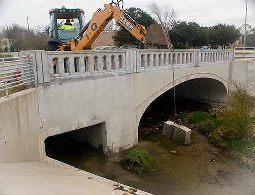
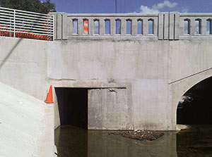
Poor Farm Ditch Restrictor, Holcombe Blvd. at Edloe St., West University, Texas. . . Well, at least as long as Brays Bayou is able to handle whatever rains come. Late last month, an excavator (pictured above) yanked out the last piece of a 3-year-old 6-ft.-by-6-ft. concrete panel used as a “restrictor” and meant to make sure rainwater that fell in West U stayed in West U for a good long time. The restrictor (shown in place blocking the right side of the drainage channel pictured at left) had been put in place by the Harris County Flood Control District after West U, working with the city of Southside Place and Metro, completed $8 million worth of drainage improvements in 2010 on the colorfully named Poor Farm Ditch, which drains along the east side of Edloe St. through much of West University and further south to Brays Bayou. Those improvements had been meant to solve West U’s frequent flooding problems. But without some place for the water to go, that solution for West U might have caused flooding elsewhere downstream. So the district placed the restrictor on Poor Farm Ditch on the south side of the Edloe St. bridge across Holcombe St. — until the city could somehow come up with 13.5 acre-ft. of flood detention to hold the runoff.

With flood improvements completed but the restrictor still causing water to back up on Poor Farm Ditch, West U flooded again in January 2012 after a hard rain.

CONTINUE READING THIS STORY

The Rich Floodwaters of Poor Farm Ditch
01/09/14 10:15am

Plan for Memorial Park Demonstration Project, Buffalo Bayou near River Oaks, Houston

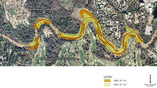
in this week’s Houston Press, writer Dianna Wray wades into the murky waters surrounding the Harris County Flood Control District’s plan to move and rebuild the banks of Buffalo Bayou where it winds between Memorial Park and the River Oaks Country Club. The method of “natural channel design” the district plans to use in the $6 million project is meant to keep the bayou in place, using downed trees instead of concrete. But weren’t bayous born to wiggle? “If the Army Corps of Engineers approves the Memorial Park Demonstration Project permit application,” Wray writes, “construction workers could move in by the end of this year, using heavy equipment and saws to reshape the bayou according to a pattern that should, if the method is successful, lock the waterway into a form it will hold for generations to come. If the effort fails, the entire project could be blown down the river by one heavy flood, leaving nothing but naked, unprotected soil where the last of an ancient forest once stood.”

Plan of Memorial Park Demonstration Project: Harris County Flood Control District

The Banks of River Oaks
11/20/13 4:30pm

Rendering of Floating Astrodome by HiWorks Architecture and Erica Goranson

Sure it’s dug 35 ft. into the earth now, but who’s to say sometime after an additional 3 decades or so of mulling it over we couldn’t insert a steel hull under the thing — so that when the waters of the rising Gulf came for Houston, the Astrodome, stuffed with valuables and maybe a species specimen or two, couldn’t just up and spirit itself away? Of course in this scenario the whole Reliant Park area has already reverted to swamp, and raised-seawall Galveston’s been entirely underwater for a number of spring break cycles. It’s 2050, and after an extra water surge from Hurricane Rick — Rick? — overcomes the submerged island’s new dike, Houston has just a little bit of time left to get the Dome up on moorings, so the gently but steadily rising waters can lift it and carry it off to sea.

“One of the best things about this proposal,” writes the distinguished Reliant Stadium-loathing jury, not missing a beat, “is that it gets the dome away from its neighbor.” And so: second prize for “The Houston Ark,” by San Antonio architects Brantley Hightower (of HiWorks) and Erica Goranson (of Lake Flato Architects), in the strangely timed whatever-shall-become-of-the-Astrodome design competition sponsored by The Architect’s Newspaper and the zippy folks at YKK AP, whose winners were announced earlier this month.

What would this cargo-laden Astrodome carry?

CONTINUE READING THIS STORY

The Houston Ark
11/06/13 10:00am

That vague line of pink barely visible low in the forested area just beyond the backyard of this house on Warm Springs Dr. in Post Oak Manor marks a few of the hundreds of trees the Harris County Flood Control District plans to knock down as part of a second phase of work on the easternmost portion of the Willow Waterhole Stormwater Detention Basin complex. Most of the trees slated for removal are in a 5-acre zone to the southeast of Post Oak Manor (outlined at the bottom right of the aerial map below), just north of South Main St. and directly to the southwest of Beren Academy. But the pink line is part of a separate 2-acre strip that’s slated for thinning just south of Post Oak Manor. And that’s got some residents there — and in adjacent ‘W’ neighborhoods Willowbend, Willow Meadows, Willowbrook, and Westbury — upset.

CONTINUE READING THIS STORY

10/24/13 1:00pm

COMMENT OF THE DAY RUNNER-UP: AFTER THE BAYOU FLOODS “I’ve been riding the trail along the Bayou for 6 years and I’d say the flood debris problem has been greatly reduced of late. That might just be a result of the drought, but certainly the city has been quicker to send crews with fire hoses to wash the trail after floods. Some part of me misses the mess, though . . . I knew where the debris would tend to accumulate after a period of high water and developed affectionate nicknames for each patch. Why, I’d whistle as I passed through dysentery ditch, and marvel at cholera canyon. But MRSA meadows, now that was some goop, I tell ya . . .” [Patrick, commenting on Lookee What the Kinder Foundation’s $50M Is Gonna Help Build Along the Bayous] Illustration: Lulu

10/07/13 11:00am

BUILDING A MONUMENT TO GATED FLOOD CONTROL AND TOURISM Protecting the Ship Channel during an Ike-like (or worse) storm surge has led some to propose a big dike, others a big gate. But UH professor of urban planning Tom Colbert doesn’t see why we couldn’t trouble ourselves to make such protection a real sight to see too: “Colbert likes the idea of . . . connecting the Centennial Gate and its levees to the proposed Lone Star National Recreation Area, undeveloped land that would both attract ecotourists and slow floodwaters,” reports the Houston Chronicle’s Lisa Gray: “I remembered one drawing I’d seen in [Colbert’s] PowerPoint show: Happy tourists, paddling kayaks past the Hartman Bridge, on one of the byways out of the big ships’ path, waterbirds and wetlands all around. Colbert motioned southeast, toward the Ship Channel’s mouth, toward Barbours Cut, the other possible location for the floodgate. There, he said, the levees would cross the channel’s water, connecting the Ship Channel’s artificial islands — made from dirt dredged from the channel — to the shore. Enough room could be left on top of the levee for a hiking path or even for car access; for the first time, it would be possible for people to get to the Atkinson Island Wildlife Management Area — a bird mecca on manmade land — without a boat. You could even, he notes, build a tourist destination atop one of those islands: He proposes a monument to Houston, the gateway to North America, the place where nature meets industry. In some drawings, just to give people the idea, he plunks the Statue of Liberty atop a Ship Channel island.” [Houston Chronicle ($); previously on Swamplot] Photo of Fred Hartman Bridge: Chuck Wilkson

09/23/13 3:00pm

COMMENT OF THE DAY: WHEN IT RAINS, IT’S RECOUPED “I live close to Buffalo Bayou. I lost two cars during a heavy rain in 2009. The water came up too fast to save the cars. By the time I found out they were flooding they were in a couple feet of snake infested water. The insurance company paid up right away and didn’t raise my rates. These people should have no problem if they have insurance.” [jgriff, commenting on Headlines: Putting the Creek in Cross Creek Ranch; Flooding the Omni Hotel Parking Lot] Illustration: Lulu

09/16/13 2:00pm

COMMENT OF THE DAY: THE COMING FLOOD OF FLOOD INSURANCE PREMIUM HIKES “If flood insurance becomes as expensive as predicted by the Chron article, it would make large parts of Houston financially uninhabitable. Folks owning property in the Heights now have even more reason to be pleased with themselves.” [Chef, commenting on Headlines: A PAC for the Astrodome Plan; A Kibosh on Free Rail Rides to Texans Games] Illustration: Lulu
09/09/13 12:30pm

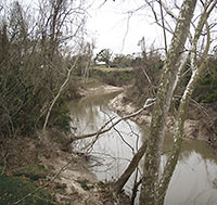
WHAT’S BEST FOR BUFFALO BAYOU? Let it flow, or let it be? Environmentalists and the Harris County Flood Control District disagree — at least when it comes to the 1.5-mile stretch that contributes to the “jungly ecosystem” of the Hogg Bird Sanctuary in Memorial Park, reports the Houston Chronicle’s Lisa Gray. A “restoration” plan proposed by the flood controllers, explains Gray, “would change the bayou’s course in places, fill in an oxbow here, reinforce banks there, widen the bayou’s channel, raising and lowering landmasses and generally move an enormous amount of dirt. [They argue] that the proposed measures are desperately needed to reduce erosion and improve water quality.” They’d do it here as they did it at Meyer Park along Spring Creek, reports Gray. But the environmentalists don’t seem to consider that to have been a “restoration” project, really: “‘Look at that!” [Memorial Park Conservancy board member Katy Emde] told me, outraged, showing me a picture of Meyer Park on her phone. ‘There’s no diversity! It’s not natural! It’s not habitat! It’s horrifying.'” [Houston Chronicle ($); previously on Swamplot] Photo of Hogg Bird Sanctuary: Bayou Shuttle

06/28/13 2:00pm

COMMENT OF THE DAY: THOSE MCMANSIONS ARE GIVING TIMBERGROVE A NEEDED LIFT “Those pics for the Shirkmere listing show some example samples of McMansions in Timbergrove and the floors appear to all be raised 3-4 feet above grade. I like those simple 50s homes but, considering the flood potential, the raised McMansions are an upgrade of the neighborhood in more ways than 1.” [Dana-X, commenting on Daily Demolition Report: Trulley, Madly, Deeply]

09/05/12 2:07pm

COMMENT OF THE DAY: ALLISON’S AIM WASN’T TRUE “. . . The phrase ‘I didn’t flood during Allison . . .’ doesn’t mean anything. Most of Houston didn’t flood in Allison either because they didn’t get the large volumes of rain that portion of the city received. Many areas of Houston flood during minor summer storms, but didn’t flood during Allison. It always just depends where and when the rain falls and also if the runoff compounds downstream.” [kjb434, commenting on Riverside Terrace Stucco Redo, With or Without Garage]