
- 36 Tiel Way [HAR]
COMMENT OF THE DAY: RETURNING TO RESTORE MONTROSE AND MIDTOWN’S RIGHTFUL TERRITORIES 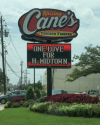 “I spent some time away from my beloved Houston. When I returned I found that ‘the Fourth Ward’ had been replaced with ‘NearTown’, and no one quite knew where Montrose was, let alone River Oaks. Please allow me to elucidate: the Fourth Ward ends at Taft; Montrose is precisely between Shepard and Taft, and Dallas and Richmond. ‘NearTown’ is a word invented by a half-drunk Realtor. It is that place on Allen Pkwy. directly underneath the I-45 overpass. ‘Midtown’ is the intersection of Main Street and Buffalo Bayou from which all house numbers in Houston radiate.” [Pat Bryan, commenting on Raising Cane’s Now Raising the Midtown Banner in Vermont Commons] Photo of Raising Cane’s at 1902 Westheimer Rd.: Swamplot inbox
THE UT AUSTIN SEGREGATION LAWSUIT THAT MADE TSU HOUSTON’S FIRST PUBLIC UNIVERSITY 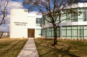 A recounting of some Houston higher-ed history comes from Ben Werlund this past weekend — namely, how University of Houston and Texas Southern University ended up as separate but adjacent public universities in the Third Ward. In 1927 the schools were founded as Houston Junior College and Houston Colored Junior College, segregated schools that eventually wound up on neighboring land after being renamed University of Houston and the Houston College for Negroes. In 1946, black Houstonian Heman Marion Sweatt was denied admission to all-white UT Austin’s law school; as the resulting lawsuit worked its way up to the Supreme Court in the pre-Brown v. Board of Education landscape of separate-but-equal requirements, the state quickly bought and renamed the Houston College for Negroes and added a law school, trying to prove that black students had comparable options to the Austin campus. “And thus, Houston’s first public university was born,” writes Werlund, to keep the Texas school system “from having to integrate its flagship in Austin.” The Supreme Court, however, didn’t buy that the new Houston law offerings measured up to the nearly 70-year-old UT law program, and UT Austin had to admit Sweatt after a 1950 ruling. TSU law professor James Douglas tells Werlund that the state legislature proceeded to cut TSU’s budget by 40 percent the next year; the private all-white University of Houston didn’t start to admit black students until 1962, shortly after which it turned public. “This was in the ’60s,” notes Douglas — “In 1964, I don’t think the people in Austin really thought integration was going to stick . . . I don’t think they ever thought this whole idea of having 2 universities close to each other was ever going to be a problem.” [Houston Chronicle] Image of Thurgood Marshall School of Law at Texas Southern University: TSU
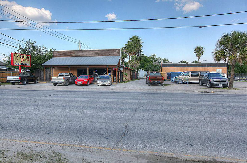
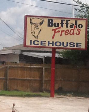 After a month or so on the market at $3.75 million, the asking price on Buffalo Fred’s Ice House has dropped by half a million as of early last week. The 37,500 sq.ft. property, positioned right across the northern boundary of the potentially moistening Heights dry zone at 2708 N. Shepherd Dr., sits a few blocks north of the ongoing culinary redevelopment zone near the recent Fiesta Mart breakup. The HAR sales listing notes that leasing the space is an option (and a matching LoopNet leasing listing has been added for the property in the last few weeks).
The listing claims the early-1980s ice house is now running on a month-to-month lease; the bar building is up for grabs along with the 2,100-sq.-ft. building formerly occupied by Speedy Cycle Lube (on the right hand side, both above and below):
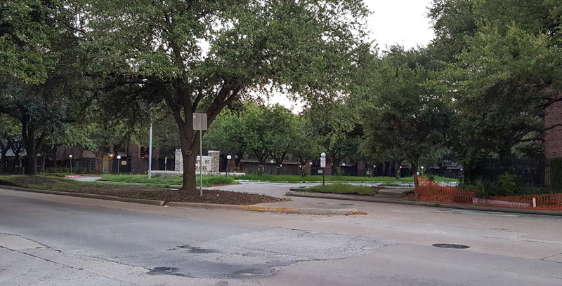
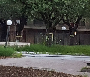 The remaining 2 thirds of the vacant Richmont Square complex are getting a few exterior decorating touches, a reader notes — among the increasingly wild parking lot median strips, many of the trees lining the Richmond-facing parking lot are sporting some new ribbons as of last week. The complex’s final tenants received an early-spring everybody-out notice, with the promise of demolition left hanging some time after the now-past May 1 move-out deadline.
What’s planned next for the space, once the last of the late-1960s apartment buildings are cleared out? Some clues come from the campus master plan map released in the Menil Collection’s 2014 annual report — 2 separate blocks south of the under-construction Drawing Institute are depicted where Richmont Square’s leftovers still stand, respectively hosting a wiggly-trailed park and a pale blue rectangle labeled for “future mixed-use” development:
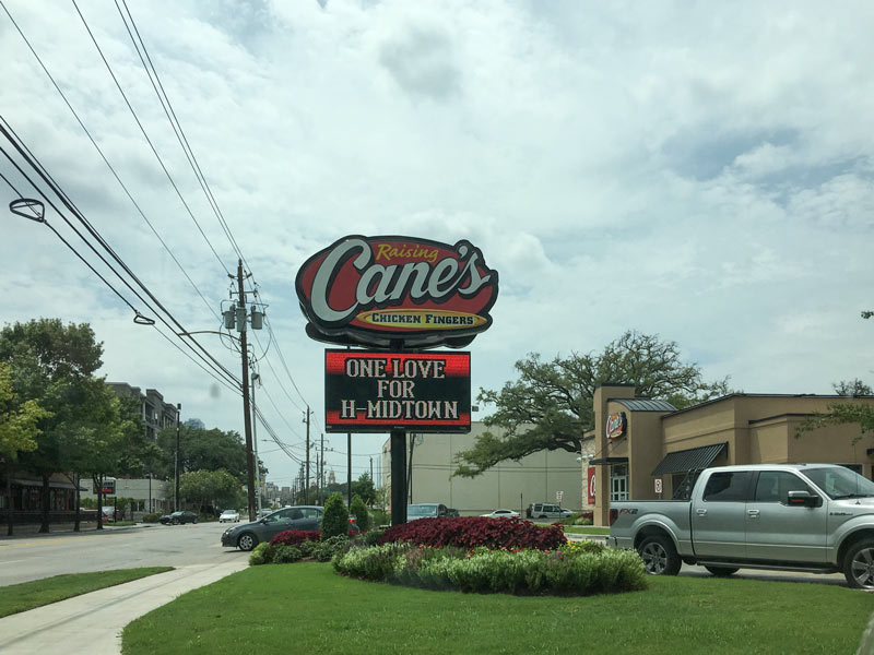
Catty-corner to the middle school both formerly and henceforth to be known as Lanier, another spat of place-name confusion is brewing: A reader notes that the Raising Cane’s (whose Vermont Commons branch sits on the corner of Hazard St. and Westheimer Rd. on the lot previously vacated by Martha Turner Properties) has been pledging its affections to Midtown. But is the message one of tribute or defection? “Do they think they’re in Midtown?” wonders the tipster. “Is there something else I’m not getting?”
Photo of Raising Cane’s at 1902 Westheimer Rd.: Swamplot inbox
WHITE OAK MUSIC HALL READY FOR FULL OPENING, NOISE CITATION HEARING 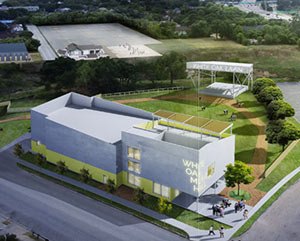 This week marks the official opening of White Oak Music Hall’s 2 indoor stages, writes Erin Mulvaney. Construction on the permanent concert spaces has wrapped next to the temporary-but-indefinitely-employed outdoor stage where the venue has been holding concerts since April. Per Jennifer Ostlind of the Houston Planning Department, all required parking for the venue is in place, though Mulvaney notes that “the temporary stage, which the partners plan to use in perpetuity for roughly 30 shows a year, did not require a permit or parking to accommodate the crowds.” Mulvaney also writes that the developers are getting ready for a September hearing on the noise ordinance citation the venue received in May; a study by hired sound scrutinizers on the night of the citation reportedly shows that sound at the venue didn’t pass 75 decibels. [Houston Chronicle; previously on Swamplot] Rendering of White Oak Music Hall complex: Shau
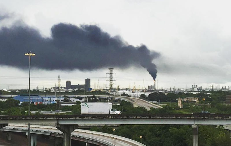
Yesterday’s entry in Houston’s recurring game of what’s-that-mysterious-black-cloud was brought to you by LyondellBasell’s Pasadena refinery at 12000 Lawndale St. (the same one that caught fire back in early April). The shot above was taken from an overpass near the junction of Loop 610 with Hwy. 225, though for parts of the afternoon the trail was visible from at least 7 miles away at the Hilton Americas building downtown. A LyondellBasell spokesperson tells Swamplot that flaring was triggered just before noon after a Calpine facility sending steam to the refinery lost power, reportedly due to a lightning strike. The company sent a message to the East Harris County Manufacturer’s Association’s emergency response info hotline stating that observers “may notice a bright orange flame, black smoke or a rumbling noise,” but that it was no big deal, and no one in nextdoor Manchester or Deer Park needed to do anything like leave or tape their windows shut this time.
Photo: Michael Muguerza via t.e.j.a.s.
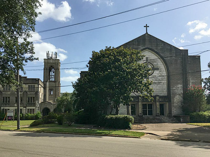
Now on the market for $2.5 million: the triangular Telephone Rd. block bounded by Dallas and Eastwood streets, complete with the still-well-labeled former complex of the storied Church of the Redeemer. The church’s congregation moved out of the literally crumbling structures in 2011 after receiving some $5-to-7-million estimates on bringing them up to minimum habitability standards. The property was later bought by Dominion Church International, which wrangled a new certificate of occupancy for the site in early 2014.
The current listing shows that the crown of T-mobile relay equipment atop the church’s bell tower appears to still be in place — county records show a rooftop lease agreement for the building was renewed for another 50 years in mid-2014:
DIVINING HERMANN PARK’S FUTURE TRANSIT NEEDS 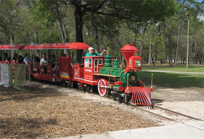 Another 20-year master plan for Hermann Park is currently in the works as the last one gets wrapped up, writes Molly Glenzter this morning. Per designer Chris Matthews, who’s working on the project as part of landscape architecture firm Michael Van Valkenburgh Associates, the planning isn’t all “fun things like choosing what tree to plant:” unlike the 1995 master plan redo, the design team this time includes a “consultant for all things mobile, which in the old days used to mean cars. Now it means cars, bikes, transit and pedestrians — how to balance all that stuff.” Matthews notes that the planning is further complicated by the need to predict what mass transit will look like 2 decades from now; Hermann Park Conservancy president Doreen Stoller adds that “with Houston getting ever more dense, each square inch of park space is becoming more precious and will need to be put to its highest and best use.“ [Houston Chronicle; previously on Swamplot] Photo of Hermann Park kiddie train: Lou Minatti
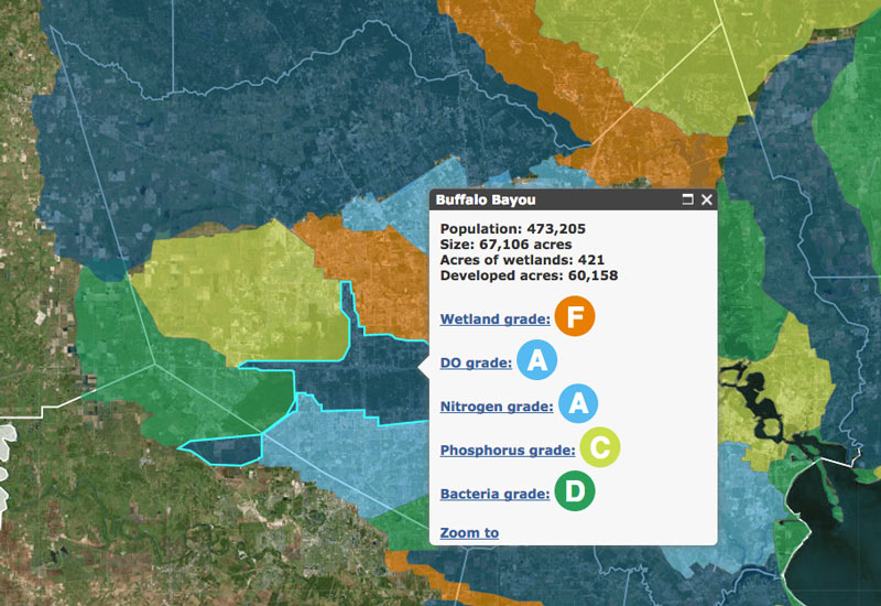
This month the Galveston Bay Foundation and Houston Advanced Research Center released their second annual report card on the health of Galveston Bay, boiling down a wide range of measurements into a series of letter grades. The report card, which looks at the bay itself along with the bayous that drain into it, aims to be easy to understand for folks with or without scientific training. Each of the 6 main categories of grade — including subjects like wildlife population trends, pollution sources, and human health hazards — is broken down with explanations of what specific measurements that rating is based on (and more details in the full report, for those who want them).
The agencies have also put together a Find Your Watershed tool, which lets you check in on how your own part of town is affecting the bay’s GPA. (That’s Buffalo Bayou watershed’s report shown above; the bayou did exceptionally well in dissolved oxygen and nitrogen content this term, but failed wetlands.) You can look up any address and see how the surrounding runoff area measures up in some of the report’s subject categories. (Note that the search tool’s map doesn’t use the same color-by-grade scheme that the rest of the report employs — you’ll have to click on each watershed to see the actual marks).
So how did the bay do this year?
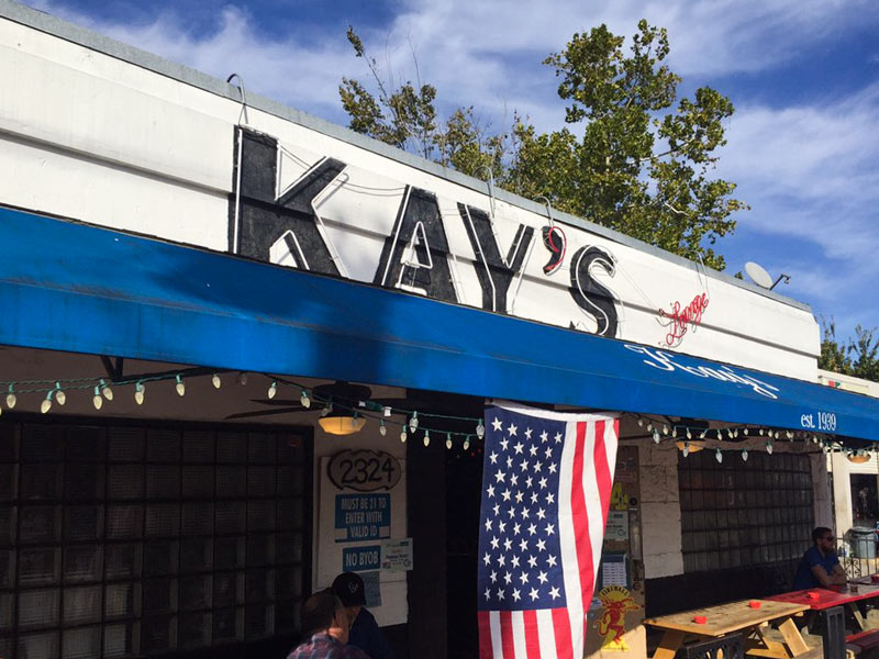
The city’s permitting records show that the land beneath soon-to-close Kay’s Lounge (and that recently freed-up cute lot next door) have been sliced into a total of 6 new pieces (not counting the shared driveway running down the middle). The application for the property line redraw, noted by a reader, was submitted last October and approved a few weeks later. The same records say the 2-turned-6 lots at 2332 and 2324 Bissonnet St. are intended for single family residences; the properties were bought last May by an entity connected to Frasier Homes. Kay’s last night in action will be Saturday the 3rd, providing final visitors with a Labor Day recovery buffer.Â
Photo: Thomas C.


