02/25/14 4:00pm

Screenshot of EPA Map of Houston Showing Relative Cancer Risk from Air Toxics

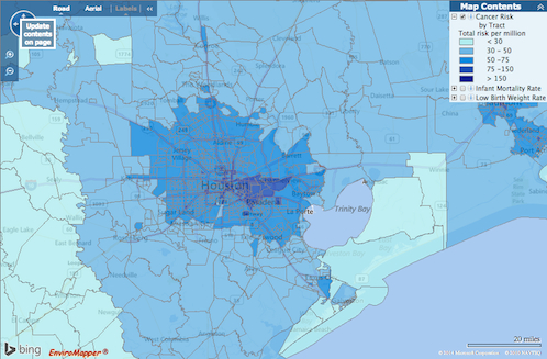
How do you feel about Houston’s airborne cancer hotspots? That’s easy! Just pick up a copy of the latest issue of Cite magazine and run your fingers over the top of it: Cite 93‘s front cover has been embossed with a map diagramming the area’s cancer risk. The places where airborne toxins mapped by the EPA are most prevalent are in the pits.

The mapped information here isn’t exactly fresh — it’s from the 2005 National-Scale Air Toxics Assessment, and the data only account for airborne known-cancer-causing toxins that are tracked by the EPA. Though it’s posted online, the map version isn’t exactly easy to find. But bravely thumbing his nose at Houston’s proud and longstanding tradition of hush-hushing location-based cancer hazards, Cite editor Raj Mankad gives Swamplot readers the secret recipe for finding the browsable map:

CONTINUE READING THIS STORY

Air Toxics, Online
08/16/13 12:15pm

Seems the concerned neighbors around that 17-story office building that Hines is considering building on San Felipe aren’t worried only about traffic. This map, created by a member of the recently formed nonprofit East San Felipe Association — which says it is committed to supporting “reasonable development” in this area around S. Shepherd, Kirby, and San Felipe — suggests another threat to the ’hood: copycatting.

Clearly speculative, the map takes pains to show those sites where other unreasonable highrises could pop up in response to the precedent that Hines is setting with 2229 San Felipe. On S. Shepherd, for ex., you might see the Red Lion Pub forgo its street-level scale, or Petco abandon the confines of its big box. (But wouldn’t that long elevator ride down give you some quality time to bond with your recently adopted pup?) If this map is to be trusted, it seems like it would be only a matter of time before the bug spreads north and Chipotle throws up a tower of burritos. The last thing the neighbors want, says just one of the messages on that oppositional website that they set up, is for this residential area to become “the next Greenway Plaza.”

Image: Swamplot inbox

07/08/13 10:00am

Last week’s announcement by Chevron of the 50-story tower it plans to add to its blue-glass twins is just the latest development in the 77002. This map from the Downtown Management District shows projects that are recently completed, under construction, or in various states of planning and speculation. Those projects, denoted by purple and yellow on the map, include Skanska’s 34-story office tower that’s replacing the old Houston Club Building, Hines’s highrise on Main, the residential renovation of the Texaco Building, and the 5-story apartment complex near the under-construction SkyHouse apartment tower, among others. You can scroll through a complete legend for the map after the jump:

CONTINUE READING THIS STORY

04/03/13 10:15am

Map of Houston from Houstonia Magazine

This is a Houston that no one’s ever seen: The lines in the swamp have been drawn for new monthly magazine Houstonia’s inaugural issue, which landed on newsstands last Thursday. This map’s “competing fiefdoms” suggest what’s really happening here: Those of you north of I-10 are now making a home in “The Hypes.” And that up-and-coming former industrial wasteland east of Downtown’s been dubbed “New Montrose.” West of the Galleria? That’s “Breastheimer.” South of I-10 near Memorial Park and the Loop is “Hogg Heaven” and “Pretensia,” just east, of course, of the mansions in “Pricey Point.” And Midtown’s been divided by the light rail, split into West “Hipstamatica” and East “Yuppie Tenements.”

Drawing: Dan Derozier

03/25/13 10:00am

NOW ON YOUR MOBILE DEVICE: WHY YOU CAN’T BREATHE A team comprising researchers at UH, Air Alliance Houston, and the American Lung Association have launched OzoneMap, an app that “monitors chemical weather,” reports John Metcalfe of The Atlantic blog Cities. And whether the app helps explain your coughing fit or alerts you to the chance of a really pretty toxic sunset, the best part is that it’s only available in Houston! And why Houston, of all places? Besides the industrial flares, that is? Here’s Metcalfe: “The Houston/Baytown/Huntsville region comes in eighth place for most ozone-polluted cities in America, as ranked by the American Lung Association. Persistently sunny weather, a battalion of petrochemical facilities and scads of fuming cars on the road make Houston a nightmare for anyone who’s chemically sensitive. For these folks, walking outside is like playing a lower-stakes version of Russian roulette, with 30 to 40 days of the year fogged with hazardous levels of ozone.” [Cities; previously on Swamplot] Map: Cities

03/06/13 11:30am

Each of these purple specks — or black holes, depending on your perspective — represents a demolition permit issued by the city in 2012. The planning and development department has posted this and a few other maps online with an overview of demographic data.

After the jump, you can see in more detail the demos inside the Loop from 2012 and 2011, juxtaposed with other maps showing the permits for single- and multi-family construction. You know. For balance:

CONTINUE READING THIS STORY

02/22/13 3:00pm

A native Houstonian has set up a one-man bicycle-messenger service, reports Culturemap’s Whitney Radley: Within an hour, Clutch Delivery’s Liam Musgrave will pedal to your place almost anything — except dry cleaning, pets, and “illicit substances.” This map shows his service area, extending west out to the Loop and east to Lockwood.

CONTINUE READING THIS STORY

02/20/13 3:15pm

What’s the state of Houston? It’s right here: Fake is the New Real’s Neil Freeman redrew the 50 states, dividing them into parcels of about 6.2 million people so as to distribute electoral college votes more equally. The Lone Star State, this hypothetical map shows, has to be broken up. You’ve got Big Thicket in the middle, with Trinity, comprising Dallas and Fort Worth, tucked inside. Chinati expands up to El Paso along the Rio Grande. And you knew it had to be true: Houston stands alone.

You can see the new 50 states after the jump:

CONTINUE READING THIS STORY