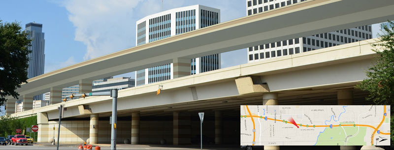
TXDOT TO PIERCE ELEVATED: YOUR YEARS ARE NUMBERED, PROBABLY 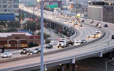 Pending a vote next month by the Texas Transportation Committee, some early-stage projects connected to TxDOT’s plan to reroute I-45 and the whole downtown freeway exchange system could be getting started a few years sooner than TxDOT officials initially thought they would, Dug Begley writes in the Chronicle. (Those early stages include the reworking of the bottleneck on northbound US-59 where Spur 527 now peels off 2 of the freeway’s lanes just before SH 288 merges into the mix.) The first few projects “are incremental compared to the overall plan,” writes Begley, but “officials say [the projects] are important and send the clear message: The I-45 freeway is relocating and the elevated portion along Pierce will be abandoned and maybe demolished within the next dozen years. . . .Work on revamping the freeway intersections is slated for late 2020 or early 2021.” [Houston Chronicle; previously on Swamplot] Photo of Pierce Elevated: Russell Hancock
Sign up for the Newsletter
Transportation

HOUSTON-TO-DALLAS BULLET TRAIN PUTTING THE BRAKES ON ALL THOSE LAWSUITS 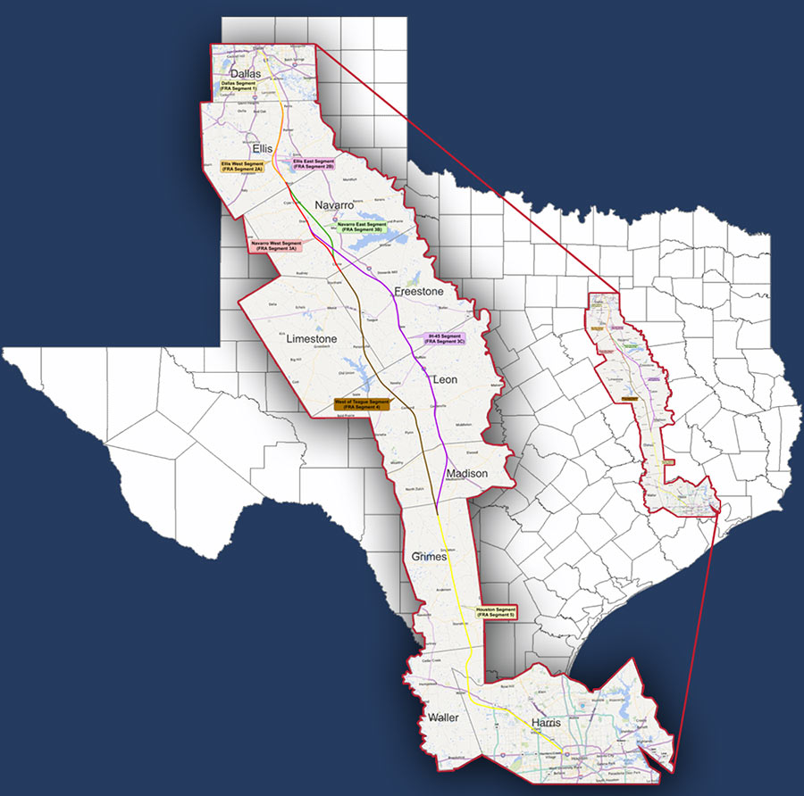 The company planning to build a bullet train between Houston and Dallas appears to be altering the legal strategy it had been using to try to get landowners to allow crews on their land to survey property along the proposed 240-mile route. Texas Tribune reporter Brandon Formby says Texas Central Partners has withdrawn 17 lawsuits across the state (including one in Harris County that had a trial scheduled for July) and settled 21 others that had sought court-ordered access. Officials of the private company now say they will seek an “open dialogue†with property owners about letting crews in. The company tells Formby it has already reached land-purchase options with more than 3,000 landowners, accounting for 30 percent of the total number of parcels it needs, and 50 percent in the 2 counties along the route adjacent to Harris County: Grimes and Waller. The company announced last week that the train is now expected to begin operating in 2023. [Texas Tribune; Houston Business Journal; previously on Swamplot] Map of proposed high-speed rail routes: Texas Central Railway

HOUSTON-DALLAS BULLET TRAIN SHOWS UP ON TRUMP INFRASTRUCTURE PROJECT LIST 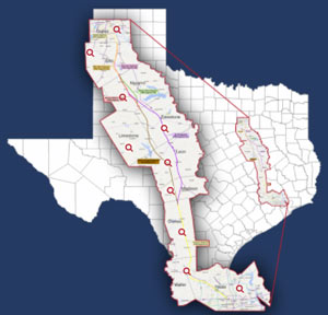 The already-in-lawsuit-phase Dallas-to-Houston high-speed rail project is number 13 on a list of 50 “Emergency & National Security Projects” floated around by the Trump transition folks, according to a report from McClatchy and the Kansas City Star (which posted the document online this week). The list looks closely related to one sent out by the team to the National Governor’s Association late last year, soliciting other ideas for projects that a hypothetical future investment program might target for funding; the bullet train project shows up only on the more detailed version of the list (which could be just another draft). Both versions of the list include the Cotton Belt Line commuter rail project, which would connect Dallas-Fort Worth International Airport to Plano. [McClatchyDC via Texas Tribune; previously on Swamplot] Map of proposed high-speed rail routes: Texas Central

COMMENT OF THE DAY: HOW HOUSTON’S PARK(ING) PROPONENTS SHOULD TAKE IT TO THE STREETS 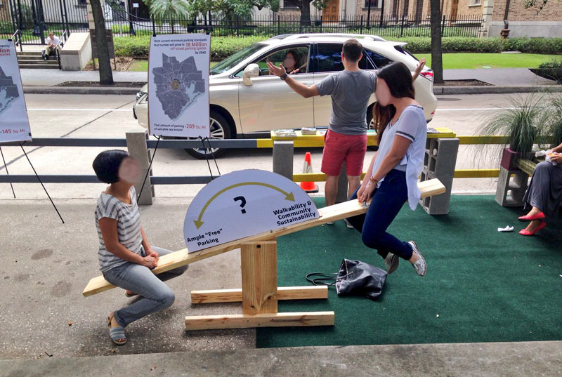 “While I understand, generally, the sentiment behind this initiative, I think in Houston it may be a little misguided. If we want a more walkable environment, with fewer buildings set back behind parking lots, we actually need more on-street parking spaces (to both accommodate business patrons arriving by car and help buffer pedestrians on the sidewalk), and fewer off-street ones.” [LocalPlanner, commenting on The SUV-Sized Parks Parked By City Hall Will Expire in About An Hour] Photo of Park(ing) Day: Allyn West
 Proponents Should Take It to the Streets... "Pin It")
COMMENT OF THE DAY: THE HIGH-SPEED RAIL BUBBA RESCUE SCENARIO  “HSR going bankrupt isn’t the worst deal around. Consider: TCR takes a bunch of Japanese + hedge fund money, fails to pay off capital costs, goes into receivership, forfeits the right-of-way to the state for failure to pay back taxes, TxDOT leases right-of-way for 99 years to a consortium of investors led by Tilman Fertitta, after which all trains have cocktails and coconut shrimp served on board. I wouldn’t complain.” [Purple City, commenting on Land Purchases Beginning Along Proposed Houston-to-Dallas Bullet Train Route]

HOUSTON IS THE UBER OUTLIER 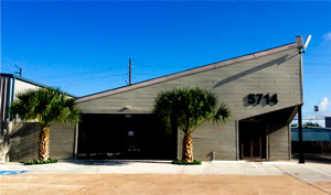 Houston appears to be the only market in Texas in which Uber is willing to put up with regulations that complicate its business model, writes Madlin Mekelburg in the Texas Tribune — following the rideshare company’s abrupt cessations of service in Midland and Galveston on Monday. In Austin, Uber and competitor Lyft are currently funding a campaign against a recently passed city ordinance that would require more intensive background checks involving fingerprinting of drivers — a safeguard Uber accepted in Houston. “Sarfraz Maredia, Uber’s general manager over Houston, declined to say Tuesday why the company wouldn’t accept the same policy in Austin,” Mekelburg writes. “‘It has become clear that Houston is the outlier in how it has chosen to regulate,’ Maredia said. ‘The rest of our markets have focused on passing modern ride-sharing regulations. As a result, our expansion strategy in Texas has changed to focus on launching only in markets that are consistent with that policy.'” [Texas Tribune] Photo of Houston Uber HQ, 5714 Star Ln.: Uber Houston

Love that rush of vertigo from driving up the entrance ramp at Hidalgo St. onto the southbound West Loop? Freeway thrill-seekers may have some new options in a few years. The above rendering of new elevated express lanes along the West Loop between I-10 and 59 made an appearance at last night’s TxDOT Open House, where plans for the proposed project were presented for public comment. The drawing faces southwest across the intersection of San Felipe and 610 toward the Williams Tower (far left), and shows the lanes flying high over the existing freeway.
TxDOT also showed schematics and cross sections of the proposed additions — which include previously-considered dedicated bus lanes elevated along the path of the feeder road, from just south of I-10 to the junction with Post Oak Blvd.
Drive through the cross sections below, from north to south:
Up High in Uptown

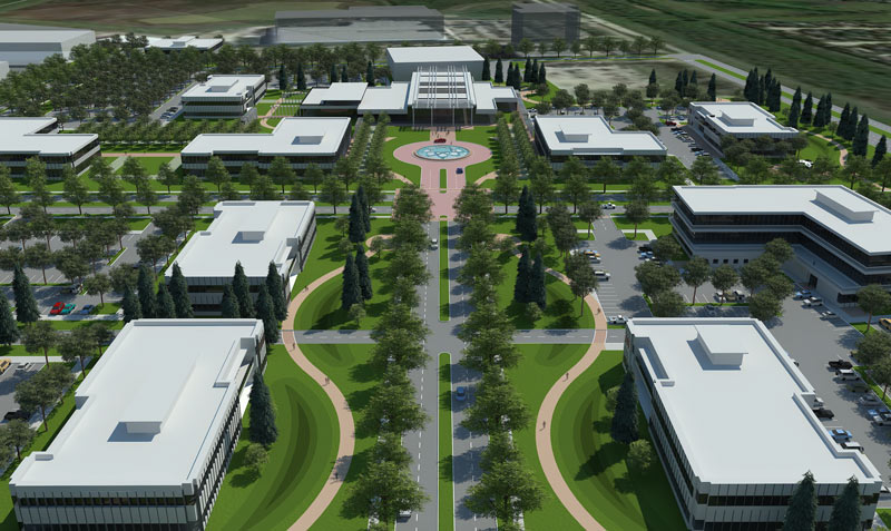
Renderings presented for the first time at last month’s Spacecom convention show the latest round of updated designs for the first phase of the planned spaceport campus that will nestle between the existing Ellington Airport runways and Space Center Blvd. in Clear Lake. The images show a campus that is notably more conventional than what might have been suggested by the curvilinear designs released in 2013. The new plans most resemble a suburban office park version of Thomas Jefferson’s plan for the University of Virginia, complete with surface parking lots tucked behind 2-story buildings stepped back from a central roadway axis.
Ellington Swing

With a row of Downtown towers looking on from the south, 2 lanes are being added to Burnett St., along the northern boundary of the 50-acre site formerly known as the Hardy Rail Yards. The thickening runs between N. Main St. and Hardy St. At the western end of that stretch, next to the Burnett Transit Center stop on the Red Line’s northern extension, a new baby intersection has been born at Freeman St. just in front of the rail overpass, just up a ways from the N. Main tunnel:
Grid Growth

COMMENT OF THE DAY: HOUSTON’S PRIMARY UNIT OF MEASURE  “Unfortunately it will take much more than sprucing up Buffalo Bayou Park to make Houston a more pleasant place. The big problem is that for most people in Houston, the only way to get to a nice place like BBP is the only way you can get anywhere — by car. And that fact alone will take years of political will, planning, and hard work to change. And as long as it doesn’t change, Houston will remain what it is currently: a road system that people sleep and work around.
The primary datum in a place like NY is the human body. Planning with the human body as the primary reference point generally makes for a pleasant place for people. Here in Houston, the primary unit of reference is the automobile, as such Houston primarily accommodates cars, not people. Scale matters. Infrastructure (such as sidewalks, small neighborhood parks, bike lanes, rails, etc) matters.
Buffalo Bayou Park is a nice place because it is designed for people. Houston on the other hand . . .
In terms of civic amenities and property values, ‘you can’t have both’ only in the market as it currently exists. We ought to be able to have a decent city and also live in it, but that can’t happen until we decide to decide that enough’s enough and begin actually planning our city.
There are people and institutions in Houston working hard to that end, but so far they are too much ‘a voice in the [civic] wilderness.’ I’m optimistic though. I see people noticing what makes a nice city, where our shortcomings are, and working toward implementing necessary changes.” [Andrew, commenting on Comment of the Day: The Buffalo Bayou Park Pinch] Illustration: Lulu
“Unfortunately it will take much more than sprucing up Buffalo Bayou Park to make Houston a more pleasant place. The big problem is that for most people in Houston, the only way to get to a nice place like BBP is the only way you can get anywhere — by car. And that fact alone will take years of political will, planning, and hard work to change. And as long as it doesn’t change, Houston will remain what it is currently: a road system that people sleep and work around.
The primary datum in a place like NY is the human body. Planning with the human body as the primary reference point generally makes for a pleasant place for people. Here in Houston, the primary unit of reference is the automobile, as such Houston primarily accommodates cars, not people. Scale matters. Infrastructure (such as sidewalks, small neighborhood parks, bike lanes, rails, etc) matters.
Buffalo Bayou Park is a nice place because it is designed for people. Houston on the other hand . . .
In terms of civic amenities and property values, ‘you can’t have both’ only in the market as it currently exists. We ought to be able to have a decent city and also live in it, but that can’t happen until we decide to decide that enough’s enough and begin actually planning our city.
There are people and institutions in Houston working hard to that end, but so far they are too much ‘a voice in the [civic] wilderness.’ I’m optimistic though. I see people noticing what makes a nice city, where our shortcomings are, and working toward implementing necessary changes.” [Andrew, commenting on Comment of the Day: The Buffalo Bayou Park Pinch] Illustration: Lulu

COMMENT OF THE DAY: WHERE’S OUR MEMORIAL PARK BYPASS?  “This ramp will now allow more traffic to use Shepherd as an alternate to the freeway system. Thus creating longer delays for those who use surface roads to travel. What is sorely required is a road that would flyover Memorial Park adding a much needed way to travel from the inner loop north. Currently, the only options are the West Loop and Kirby/Shepherd. Both of which are overly congested at most times of the day. It doesn’t help that Shepherd is down to two lanes from four in stretch from Westheimer to Dallas while the city installs much needed storm drainage.” [jgbiggs, commenting on Your Upgrade from Shepherd Dr. to the North Fwy. Will Be Much Smoother Starting Today] Illustration: Lulu

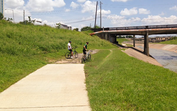
Reader Scot Luther, who claims to have witnessed “wrecks and several flat tires” on a gap in the bayou-side trail along the north side of Brays Bayou just across N. MacGregor Way from the eastern border of Hermann Park wonders why this portion of the several-year-old concrete trail was never completed. Here’s a photo of the scene — where more cautious bike riders regularly dismount for the muddy or bumpy path under the Almeda Rd. bridge. A few hundred ft. beyond the bridge, the trail picks up again on its way to Riverside Terrace.
Photo: Scot Luther
Water’s Edge

HOUSTON METHODIST’S NEW SUBURBAN-STYLE TMC HELIPAD  From reader Stephen J Alexander comes this pic of the new helistop that’s landed at the corner of Bertner Ave. and S. Braeswood, just over the southern (Brays Bayou) border from the Texas Medical Campus, as viewed during construction last month. It’s directly across the street from M.D. Anderson’s 25-story Mid Campus Building 1, but the helicopter landing pad is a project of Houston Methodist Hospital, according to permit info posted onsite; it sits on a portion of Methodist’s West Pavilion remote lot. Photo: Stephen J Alexander

If you were dazzled by the wide swaths of concrete laneage and complicated color-coded spaghetti interchange entanglements in the TxDOT renderings released last week — but had trouble comprehending the massive scale of the proposed reroute of I-45 around Downtown — you’ll want to try this second go at it. The state transportation agency has now produced a video version of its freeway-rewrapping proposal, complete with tiny little animated cars and trucks moving along 3-D representations of those new wide surfaces. It’s so mesmerizing, many viewers may not even notice what happened to the Pierce Elevated.
- Previously on Swamplot: The 5 Wackiest Images from TxDOT’s Plans To Reroute I-45 and Abandon the Pierce Elevated
Video: TxDOT, via Houston Chronicle
North Freeway Downtown Rewrap

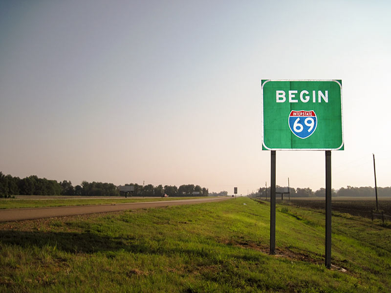
Snickers and awkward guffaws are likely to be heard all the way from the Northside to Afton Oaks next week, once state transportation officials sign off on the addition of another name to the 11.9-mile segment of State Hwy. 59 within Houston’s Inner Loop: Interstate Highway 69. New signs announcing I-69 proudly to the world will subsequently be erected along in-town stretches of the freeway, where they’ll likely be targeted for pointed display in neighborhood bars, strip clubs, or dorm rooms.
Once complete, I-69 will connect the highway’s head at the Canadian border in Port Huron, Michigan, to its tail along the Mexican border, where it will spread into 3 separate paths to Laredo, McAllen, and Brownsville. Planners hope the availability of a smooth, continuous ride from north to south and back again along the eventual federally sanctioned route (sometimes called the NAFTA Superhighway) will stimulate and ease trade among the entwined nations.
Making the Link
