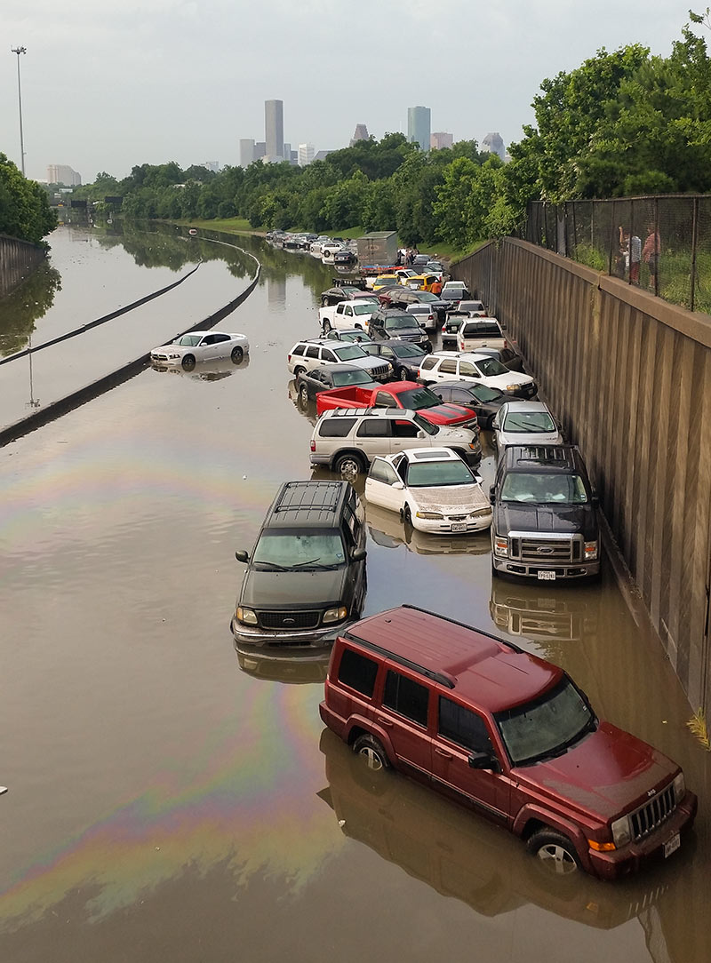
If you’re compiling a list of best photo spots for during or after another one of Houston’s every-dozen-years-or-so never-seen-anything-like-it flooding events, you’ll probably want to make room on it for the stretch of I-45 North between the N. Main St. and Patton St. exits. Back in 2001, images of cars and trucks floating along an insta-lake in this same spot made national news. And yesterday, pix of the automotive flotilla pictured above found their way to Facebook feeds and front pages around the globe.
But the low spot just north of Downtown wedged between Brooke Smith and the Near Northside was also a tough place to be when the water started rising, reports the Chronicle‘s Dane Schiller. Drivers found an early morning traffic jam in the rain changed nature quickly: “A surge was coming at them, squeezed by high barrier walls into the confines of the interstate. In less than 15 minutes, there was nothing to do but abandon ship.”
CONTINUE READING THIS STORY


 “Biggert-Watters would have destroyed the home market in many of Galveston’s West End beach communities. My wife and I were looking at homes just as the revised rate plan went into effect in late 2013. The quote I received for JUST FLOOD INSURANCE on a $250K house was $40,000 per year. As long as the government allows federally backed mortgages in these areas, they will have to subsidize the insurance rates. It really is that simple. If the rates aren’t subsidized, the market will collapse for these homes. It will be a vicious circle. Those that need a mortgage to afford a home won’t be able to afford insurance. Those who own a home with a mortgage won’t be able to afford insurance. Homes will only be marketable to cash buyers who can self-insure. How much would you pay for a home that you could only market via an owner-financed or cash transaction? A property that would essentially be unmarketable to buyers via traditional mortgage.” [
 “There is no market at all for flood insurance. It’s a massive federal subsidy that is merely administered by private companies.
You can’t effectively insure against floods.
This is one of those things many Texans like to ignore — that our coastal development is highly subsidized in the form of the government-backed NFIP.” [
 “Does anybody else feel Houston looks really great in a flood? Other cities have mountains or snow or awesome historic architecture, colorful boisterous festivals . . . But from what I see, flooded Houston is green and peaceful — the perfect spot to live!” [
 SUV-deprived Woodland Heights resident Mimi Swartz explains how she and her husband came to spend the very wet night of May 25th reclined in the front seats of their Honda Civic in the parking garage of the Edwards Greenway Grand Palace 24 at 3839 Weslayan St. — with a flank steak thawing in the wayback. They were on their way to a dry, refrigerator-equipped hideaway at the Hotel Derek when a stalled train and some high water blocked their tracks: “Next thought: About 0.7 miles to the south was a multiplex. We could catch a late show. Afterward, surely, the rain would have stopped and the water receded. If not, this place at least had covered parking. All during the 10:45 show of ‘Mad Max: Fury Road’ — four other rain-soaked refugees had had the same idea — I couldn’t help thinking that if we’d had a truck like that of Charlize Theron’s character, I’d be asleep in bed instead of wondering how someone had managed to digitize her arm out of every shot.
By 12:45 a.m., the rain had not stopped. For a while, we stood in the parking garage beside the car, and I tried to snap cellphone photos of the lightning.
  “My neighborhood flooded in Allison in 2001, and then again on Monday night. I can’t tell you how many ‘so much for the 100-year flood plain‘ comments I heard walking up and down the street.
What it really means is that it is a flood (or more properly a storm, or my favorite, ‘rain event’) that has a 1% chance of happening every year. So what that really means is that if you live in the ‘100 year flood plain’ you have a 26% chance of flooding during your 30 year note. And for many of these areas the 100-year storm on which these maps are based have 100 years or less of accurate rainfall data.
A better rule of thumb is to remember: (1) if you live near a bayou and it rains A LOT, you will probably flood at some point. (2) if it’s raining A LOT and the road you are on dips below the grade of the adjacent roads, it’s probably going to flood and (3) if it’s raining A LOT where you are in Houston, you can count on it flooding.” [
 “Has anyone posted a map of the residential streets that flooded yesterday? I’ve seen neighborhoods mentioned wholesale, but I also understand it was hit-and-miss from street to street. Thank you!” [