ONE WAY TO GET RID OF THAT PESKY TRAFFIC: TAKE AWAY THE STREETS 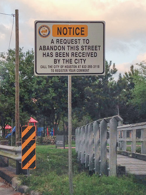 Signs are up around the Memorial City Apartments at 872 Bettina Ln., immediately south of the Memorial City Mall and adjacent to Frostwood, announcing a request that the city abandon portions of Bettina Ct., Strey Ln., and Kimberley Ln. (where the above photo was taken). The request was submitted by the limited partnership that owns the apartments. Its purpose, according to the city’s public works department, is “to reduce the amount of cut-through traffic in the neighborhood.” If granted, the complex would grant the city utility easements over the existing right-of-way. There’s more to it, according to the public works department: “Right-of-way will also be conveyed back to the City for a cul-de-sac to be constructed at the new terminus of Kimberley Lane, which will provide a connection to the driveway in to Bunker Hill Elementary. The cul-de-sac will also contain a 911 emergency gate to allow emergency vehicles to access the apartment complex from Kimberley Lane. Access to Bettina Court and Strey Lane will remain open from Barryknoll Lane, but any traffic turning on to these streets after the abandonment will only be able to access the apartment complex. Signs notifying the public of the subject request were posted April 3, 2015 and will remain up for 30 days.” So is everyone on board with this? So far, only 9 calls have been made to the city in response to the signs, with just one objecting to the deal. Photo: Swamplot inbox
Sign up for the Newsletter
Streets

COMMENT OF THE DAY: THE SIGHTS OF MONTROSE  “Look at those pictures! The cityscape in Houston is so beautiful that I sometimes want to cry. I love the setbacks, the crumbling streets, the large signs, the little bit of grass, and oh man oh man those two lonely palm trees. This is the part the Houston that I want to show off to my friends. After a nice dinner at Uchi, I love to take everyone on a stroll around my beautiful city!” [Duston, commenting on What’s Arriving Now at the Sleepy Corner of Westheimer and Montrose]

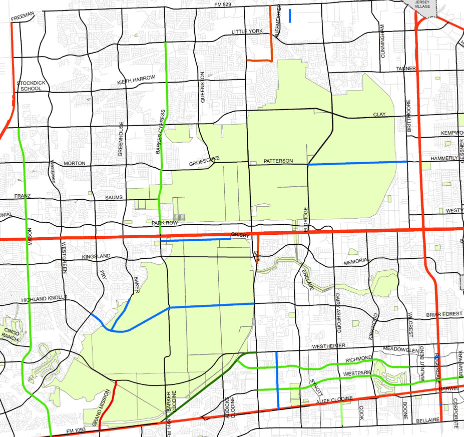
 There’s a rather bold new plan for 2 of the Houston area’s major parkland reserves hiding in an image included in an almost-final draft of the West Houston Mobility Plan being prepared by the Houston-Galveston Area Council for submission to TxDOT. A new roadway connecting Briar Forest Dr. to Highland Knolls Dr. through the heart of 7,800-acre George Bush Park is shown in a proposed major-thoroughfare plan for the area. (See segments in blue in image above.) A segment of Baker Rd. is also shown linking to the new parkway. And north of I-10, a similar major roadway is seen connecting Hammerly Rd. to Patterson Rd. — through the Addicks Reservoir.
Connecting Briar Forest Dr. to Highland Knolls

COMMENT OF THE DAY: WHY THERE’S SO LITTLE TRAFFIC DOWNTOWN  “Downtown traffic is some of the easiest traffic of any US city downtown I have ever been to, and actually some of the best traffic in all of Houston. Why? As near as I can tell, it’s because: (1) street parking is virtually not allowed or limited to one side of the street, which prevents people from aimlessly circling around looking for that one free spot; and (2) one-way streets. People complain about one-way streets as confusing but when there is a good grid like downtown or midtown, they work perfectly. I can’t ever recall sitting through more than one cycle of a light in midtown. There are other areas of Houston where this can easily be done. And ban street parking completely on major roads after 4pm. It’s just valets making money off blocking traffic after a certain hour.” [John Chouinard, commenting on Comment of the Day: A Few Remedies for Those Traffic Problems You’ve Been Having] Illustration: Lulu

THE APARTMENTS THAT WANT EXXONMOBIL PASSAGE  Here’s a rendering of the complex Alliance Residential has just started building north of the ExxonMobil campus. The 3-story, 341-unit building will be located on 1615 Sawdust Rd. — which the developer appears to hope might be used as a kind of driveway for that big new campus in the pines to the southeast: “Alliance said there are plans to extend Sawdust, which will provide an avenue leading directly to the . . . campus without getting on Interstate 45,” reports the Houston Business Journal. “However, this portion of the project is still in the planning stage and is waiting for funding from the city.” Alliance is also building the midrise Broadstone 3800 complex at the corner of Alabama and Main. [Houston Business Journal; previously on Swamplot] Rendering: Alliance Residential Co.


That no-tracks land along Harrisburg Blvd. between 66th and Cowling on the East End Line is supposed to look something like the underpass that these new renderings depict. Right now, though, Harrisburg isn’t passing under anything — but lying in wait instead between the nearly completed eastern and western sections of the line that stop here dead in their tracks. Though Mayor Parker announced more than 2 years ago that the East End Line would get $20.6 million in diverted funds to build the Hughes Underpass below the Union Pacific East Belt freight rail line, construction hasn’t started. Why? Well, it appears that Metro hasn’t selected a company yet.

")
There are almost 6,000 miles of street in Houston, according to the Memorial Examiner, and now about a half a mile of one in Midtown can call itself remarkable. The Greenroads Foundation, which confers on streets a kind of LEED-like designation, gave its first formal props to a project in Texas to Bagby St. between Tuam and St. Joseph Pkwy., for the $9 million in improvements built along the 0.62-mile span the past few months.
Included in those improvements are bike racks, street furniture, wayfinding signs, wider sidewalks, and narrower, less harrowing crosswalks. (You can see in the photo above that these improvements don’t include burying utilities.) But the designation isn’t meant just to make the lives of pedestrians more aesthetically pleasing: LED lights were installed; rain gardens were put in to help with drainage; “fly ash” concrete, which reduces carbon emissions, was used where possible; and Bagby itself, with its potholes, patches, and cracks, was repaved atop what the Midtown Redevelopment Authority calls “newly stabilized materials” that are supposed to require less maintenance over the long haul.
Here are a few more looks at the transformation:
 and Improved... "Pin It")
COMMENT OF THE DAY: ALL THAT FRACKING TRAFFIC  “The gear needed to frac wells on a single well-pad is unbelievably heavy. A single pump might weigh 75,000 lbs, and you use 12 or more on a single pad, not to mention a hydration unit, a blender, a manifold, a data van — and these are the things that just stay on the well site. You also have sand carried in vehicles so big that they are often called ‘sand hulks’. They come and go from a single well site constantly. And depending on how you get water to the site, that may mean even more trucks.
This army of vehicles leaves from a single yard and tends to go over some of the same roads over and over again on its way to different well-pads where the wells to be fracked are.
The point is, fracking tends to place a lot of stress on a small number of roads that are in continuous use in a given area. I work in in the frac business and am totally pro-fracking, and I think it is totally reasonable for localities (whether counties or states) to require a reasonable road maintenance surcharge from companies that operate frac spreads in an area. (Of course, it should be based on actual use.) After all, these are the same roads our employees drive on to get to work or to run errands and that their kids ride school buses on.” [Robert Boyd, commenting on Headlines: A New San Jacinto Monument Museum; Road-Buckling Fracking Trucks] Illustration: Lulu
“The gear needed to frac wells on a single well-pad is unbelievably heavy. A single pump might weigh 75,000 lbs, and you use 12 or more on a single pad, not to mention a hydration unit, a blender, a manifold, a data van — and these are the things that just stay on the well site. You also have sand carried in vehicles so big that they are often called ‘sand hulks’. They come and go from a single well site constantly. And depending on how you get water to the site, that may mean even more trucks.
This army of vehicles leaves from a single yard and tends to go over some of the same roads over and over again on its way to different well-pads where the wells to be fracked are.
The point is, fracking tends to place a lot of stress on a small number of roads that are in continuous use in a given area. I work in in the frac business and am totally pro-fracking, and I think it is totally reasonable for localities (whether counties or states) to require a reasonable road maintenance surcharge from companies that operate frac spreads in an area. (Of course, it should be based on actual use.) After all, these are the same roads our employees drive on to get to work or to run errands and that their kids ride school buses on.” [Robert Boyd, commenting on Headlines: A New San Jacinto Monument Museum; Road-Buckling Fracking Trucks] Illustration: Lulu

DITCH REPAIRS, BRIDGE REPLACEMENT TO CLOSE STRETCH OF SAN FELIPE FOR NEXT 2 WEEKS  San Felipe St. near Mid Ln. and the Loop is going to be out of commission for about 2 weeks, according to the Harris County Flood Control District: After tonight’s rush hour subsides, workers will move in to remove concrete from the sides of the eroding and underperforming drainage ditch, shown here, and install closed culverts. And that means the 50-year-old bridge on San Felipe will need to be demolished and replaced. The area to be closed is near the new Liberty Kitchen spot and the luxury apartments under construction on Briar Hollow Ln. [HCFCD; previously on Swamplot] Photo: HCFCD

WHAT TIME THE EXPLOSIONS DOWNTOWN WILL WAKE YOU UP , 1110 Main St., Downtown, Houston") A rep from Metro confirms that the booms of the controlled demolition of the former Foley’s at 1110 Main St. will begin booming between 7:10 and 7:20 this Sunday, September 22. (That’s 10 minutes past sunrise, for all you morning people.) And if you’ll be driving Downtown to find parking and get yourself in implosion position, note that the street closures that Swamplot reported yesterday will begin at 6 a.m. [Metro; previously on Swamplot] Photo of Foley’s: Jim Parsons
A rep from Metro confirms that the booms of the controlled demolition of the former Foley’s at 1110 Main St. will begin booming between 7:10 and 7:20 this Sunday, September 22. (That’s 10 minutes past sunrise, for all you morning people.) And if you’ll be driving Downtown to find parking and get yourself in implosion position, note that the street closures that Swamplot reported yesterday will begin at 6 a.m. [Metro; previously on Swamplot] Photo of Foley’s: Jim Parsons


In February, the Art Guys went for distance, walking the marathon that is W. Little York Rd.; tomorrow, they’ll be going for danger. The 9th of their “12 Events” requires Jack Massing and Michael Galbreth to maintain pedestrian safety techniques and situational awareness as they cross the street, all day, at Westheimer and Hillcroft/Voss, what they’re claiming is the “busiest intersection in Houston.”
Here’s the deal: They’ll start their day off walking clockwise, and, presumably to avoid the monotony, switch things up and go counterclockwise the rest of the afternoon. It’s unclear whether they’ll be taking advantage of the various muscle supplements and joint remedies at the nearby Vitamin Shoppe in the Westhill Village Shopping Center there on the southwest corner.
- 12 Events [The Art Guys]
- Art Guys coverage [Swamplot]
Photo of Art Guys on W. Little York Rd.: Everett Taasevigen

COMMENT OF THE DAY: HOUSTON’S 6 TRULY WALKABLE NEIGHBORHOODS  “. . . [Y]ou can have walkability even when density is just moderate. Small town downtowns are walkable even though most folks arrive by car. Many commercial neighborhoods in streetcar suburbs built before 1950 are this way. What makes them walkable: comfortable street design (sorry but 40 mph is too fast), frequent safe pedestrian street crossings, ample sidewalks in good condition, pedestrian-oriented buildings that aren’t separated by big parking lots, on-street parking (what Houston lacks in too many places), decent night lighting, and relatively small block sizes. Houston has subsets of these features in numerous places but the whole package is very rare — 19th @ Rutland, Rice Village (mainly just strip malls mushed together), Harrisburg @ 67th, the Historic District downtown, and the main gay bar area in Montrose (awful or nonexistent sidewalks though and lacking night lighting) come close, plus of course Bagby @ Gray. Hence developers building them from scratch (West Ave, River Oaks District, CityCentre, etc.) to satisfy demand.” [Local Planner, commenting on Comment of the Day: Sorry, but Houston’s Never Gonna Be Walkable] Illustration: Lulu

ALLSTON OR NOTHING: SIDE STREET NOW AT CENTER OF ALEXAN YALE APARTMENT DISPUTE  About 290 ft. of Allston St. have become the latest point of contention between developer Trammell Crow and Heights opponents to the proposed 5-story Alexan Yale apartment complex. This complex, planned immediately south of the other one, would sit on the block bound by 5th, 6th, Yale, and Rutland, with Allston running through it. The Leader reports that Trammell Crow has requested that the city abandon Allston, which dead-ends just before 5th St., so the complex doesn’t have to be discontiguous; opponents, of course, want Allston to be opened up, to help with traffic and ensure connectivity to the nearby detention basin that’s been proposed as a recreation site. The abandonment request is going to be decided upon soon by a city committee of reps from public works, planning, and the fire department — though Trammell Crow appears to have some leverage, reports Cynthia Lescalleet: “The structure could go even higher, the developer says, if it doesn’t get what it’s seeking. . . . [Trammell Crow] has ‘alternate plans’ that would add two or three floors to the building. There’s also speculation about a possible sky bridge connecting sections on either side of the still-open street.” [The Leader; previously on Swamplot] Photo of Allston St.: Allyn West

Struggling to make themselves heard above the whoosh of traffic along the Washington Corridor, Better Houston’s Pedestrian Pete (a.k.a. one-time mayoral candidate Peter Brown) and visiting Harvard prof and city planner Peter Park take a very short stroll in this recently uploaded video. Their objective? To lament the guy wires, utility poles, and other hindrances for would-be pedestrians on the few feet of sidewalk they traverse in front of Five Guys Burgers and Fries and Buffalo Wild Wings in this strip center near Leverkuhn at 3939 Washington.
- Improvements Along Wash Ave [Pedestrian Pete]
Video: Pedestrian Pete
COMMENT OF THE DAY: ONE WAY WASHINGTON AVE COULD GO “What is the plausibility of turning Washington Ave into a one-way, eastbound road with three lanes with one lane dedicated to on street parking? And then having Center St become the outbound counterpart –– three lanes, no parking, so that less additional right of way would be needed? [Vmel, commenting on Planning for the Future of Washington Ave]