05/19/09 5:19pm

What’s the status of those plans for a big Intermodal Transit Center at North Main and Burnett just north of I-10 Downtown, meant to link commuter rail and bus lines to the coming northern reaches of Metro’s existing rail line?

L.A.’s Ehrenkrantz Eckstut & Kuhn Architects are now showing off this rendering of the terminal at the company’s website, along with the kind of encomium that usually accompanies abandoned or massively scaled-back projects. Rail-watcher Christof Spieler reported back in March that the terminal project on the North Line had been “shelved (for now, at least)”; plans to extend the new East End Line to that station were abandoned last year.

Rendering: Ehrenkrantz Eckstut & Kuhn Architects

05/18/09 5:07pm

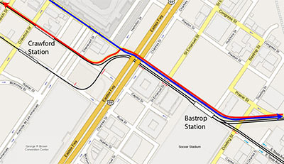
Worried the Dynamo soccer stadium planned for the superblock between Texas, Dowling, Hutchins, and Walker is gonna block traffic between Downtown and the East End? Citizen rail designer Christof Spieler solves the tangle:

There are two parts to this idea. The first is to make Texas alongside the stadium a two-way street. Instead of two eastbound traffic lanes and two light rail tracks, Texas gets two eastbound traffic lanes, two westbound traffic lanes, and two light rail tracks. That all fits in the existing right of way. The second part is to use the “squiggle” in the light rail tracks for traffic lanes as well. This does two things: it gives the westbound traffic on Texas a way to go, and it cleans up those messy intersections.

So now, to get from the East End to Downtown, you simply follow Harrisburg, which flows right into Texas, and then you make a left turn onto Capitol. And you will not hit an awkward intersection or have to cross the rail line to do it.

Map: Christof Spieler

05/12/09 7:50pm

Spurred on by family members waiting patiently at the Carrabba’s on Kirby — and the promotional whizzes at GM and CBS Radio, who’ve furnished her with a brand-new vehicle to drive for 8 weeks — mommy blogger and new Chevy Traverse spokesmom Stephanie Click ventures out from her “own little world” in Katy to . . . the scary and purportedly trafficky Inner Loop!

Will she make it? How will her blogger-swag loaner car stand up to the rigors of multi-lane Houston driving?

04/20/09 7:55am

Here’s a whizzy reel showing what the new Metro trains and stations on 4 upcoming light-rail lines are supposed to look like. Dowling St. in the Third Ward, the Edloe Station in Greenway Plaza, the Moody Park Station on the North Line, MacGregor Park Station on the Southeast Line, and Lockwood Station on the East End Line each get about 30 seconds of CGI treatment, from a low-flying camera buzzing some extremely lifelike — though torpid — pedestrians.

Christof Spieler finds a few flaws:

The Third Ward footage seems to be out-of-date; it shows the old alignment crossing Dowling on Wheeler, not the new route that switches to Alabama. But other details are correct: the stations shown are the new prototype station design (by Rey de la Reza Architects), minus artwork.

It’s nice to be able to visualize what these lines might look like. But it’s also a reminder that it’s important to get the details right. At Edloe, for example, the trees integrated into the canopy are nice, but there’s no crosswalk at the west end of the station platform, which means a 500-foot detour for some riders. The Moody Park and MacGregor stations do show that crosswalk, and the sidewalks look pretty good, too. But in all the images, the overhead wires are suspended from their own poles in the middle of the street, not from the streetlight poles on either side, as on Main Street. That makes for more poles and a more cluttered streetscape.

CONTINUE READING THIS STORY

04/13/09 2:59pm

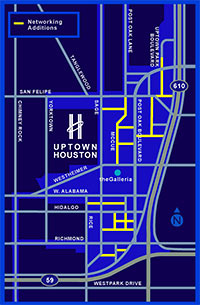
COMMENT OF THE DAY: SMALL STREET ADDITIONS TO THE GALLERIA AREA “The Uptown TIRZ and District are actively working to build a grid in Uptown. Much of it will be funded by existing and new developments by the TIRZ funds and not from the general taxpayer base. . . . [This map shows] their planned addition of grid style layout to uptown. . . . It’ll take existing private access roads and convert some to public streets.” [kjb434, commenting on Uptown Traffic Grid] Map: Uptown Houston District
04/13/09 1:03pm

MANAGING THE NEW KATY FREEWAY MANAGED LANES Those new center sorta-HOV lanes on the new Katy Freeway will go toll starting this weekend. Here’s a little primer to help you make intelligent purchase decisions at 65 mph or more: “The lanes will now be open 24 hours a day, 7 days a week. Outside of rush hours, they’re a toll road: every car, regardless of how many people are in it, pays $1.10 to go the full length of the lanes. During rush hour, in the rush hour direction, single occupant cars pay between $2.00 and $4.00 and 2+ carpools are free. Those rates will need to be adjusted if the lanes are too popular, because HCTRA (who operates the lanes) has promised METRO (who gave up the HOV lane to make room for them) that buses will keep moving at full speed. Single occupant vehicles and carpools will be sorted out by a three-lane toll plaza: left lane for carpools, right two lanes for SOVs.” [Intermodality; details]

04/10/09 11:56am

UPTOWN TRAFFIC GRID “As we all know, traffic is incomparably worse in Uptown than it is in Downtown. Downtown has more of everything: more streets, more freeways, more transit, more pedestrian use. The most important part, though, is that Downtown has the grid, and Uptown does not. Uptown is a lot less dense than Downtown, and yet it’s reaching a breaking point. There are critically few ways in and out, and even though those are mega-roads, they concentrate traffic BY DESIGN rather than diffusing traffic as the grid does. If Uptown had a fine-grained local street grid the traffic there would be a fraction of what it is today, but it’s too late to put in a grid now. The best we can hope for is for benevolent developers to include new connecting streets to break up some of the super-blocks when they come up for redevelopment.” [NeoHouston]

04/02/09 10:50am

Great real estate video takes time. Bicyclist and blogger Dave McC has been very patient:

I’ve been waiting for a year since this place was finished to time it right for a good photo op. Today was that day! Houston has some wonderful examples of Developers Gone Wild (TM). This is a great one . . .

CONTINUE READING THIS STORY

03/09/09 12:19pm

The advance rail intelligence unit known as Christof Spieler puts together another map showing Metro’s latest plans for the new 2012 lines. What’s changed since last time?

Texas Southern University now has no stop alongside campus. There is a station called “TSU,” but it’s three blocks from campus, on the opposite side of a public housing project. Rice, UH, St. Thomas, and UH Downtown all get excellent connections to the 2012 system, but TSU is getting left out because METRO couldn’t figure out how to work with a neighborhood to get a Wheeler/Ennis route figured out. That’s an unfortunate situation for a university that’s trying to raise its profile.

CONTINUE READING THIS STORY

02/27/09 9:27am

THE ASTROLOT: HOUSTON’S NEWEST TRANSIT HUB Another scene from the active afterlife of the former theme park: The 150 acre lot formerly known as Astroworld has been empty for a while, but is expected to be packed on Friday when it will be available for rodeo parking. . . . Lighting towers will be brought in and parts of the property not suitable for parking, such as areas with holes in the ground, will be marked off. There will be entrances along the 610 feeder between Kirby and Fannin and exits off of Belfort. After the rodeo, all entrances will be used as exits so all traffic will flow out of the lot. There are only about 12,000 parking spaces on the actual rodeo site. Officials welcome the new 5,000 space parking opportunity. . . . The lot is not paved and is bumpy, two factors that do not bother some rodeo patrons. . . . ‘We think it’s great that people will be able to cross the bridge and it will bring back memories of when Astroworld was here,’ [Andi Devera of the Fazeli Group, owners of the leasing rights] said. The Astrolot opens this Friday.” [abc13; previously]

02/24/09 11:48am

Last year Transit Antenna, a 7-person “mobile living experiment,” camped out at Joe Nelson Icet’s Last Organic Outpost, did a little farming, and painted the giant “FARMART” mural at the top of the adjacent Comet rice mill. The group, which travels the country on a city bus converted to run on waste vegetable oil, documented its visit — which included a stint in the Art Car Parade — in a series of website posts.

And not long after the rambling group left its urban campground, Transit Antenna’s Seth Gadsden posted this half-hour documentary the group put together about goings-on at the Emile St. farm and its Fifth Ward neighborhood. An HD version is also available.

CONTINUE READING THIS STORY

02/09/09 11:05am

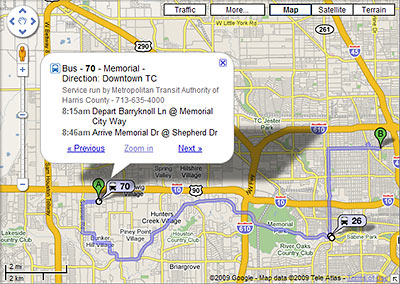
It’s now a whole lot easier to figure out how to get around Houston using public transit: Metro routes have at last been embedded in Google Maps. Which means if you use Google to plan a local trip, figuring out how to get there by bus or rail is now as simple as choosing “By public transit” from a dropdown menu. Schedule info is right there too.

So far, the public transit option shows up whenever you use Google Maps to get directions in Houston — or you can start from a separate Google Transit gateway here. Not yet activated for Houston: Google’s Transit Layer, which in other cities lets you see all the routes at once.

Even more convenient: If you can get Google Maps on your mobile phone, you now have access to bus and train directions and schedules there too. Here’s a video demonstrating how that works:

CONTINUE READING THIS STORY