01/04/11 2:52pm

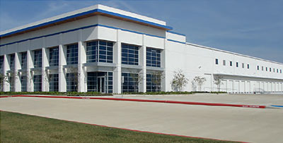
Nestlé Waters of North America, distributors of the Ozarka, Arrowhead, Calistoga, Ice Mountain, Poland Spring, Zephyrhills, Nestlé Pure Life and — yes — Deer Park brands of drinking water, has chosen to set up its next bottling operation at the corner of Bay Area Blvd. and Red Bluff Rd. But the nation’s largest bottled-water company isn’t simply seeking a Pasadena address for the convenience and caché that undoubtedly comes with the location — close to the port and just a few miles south of the city’s famed refineries and sewage-treatment plant. Nestle has also worked out an agreement with the city to use water from Pasadena’s Southeast Water Purification Plant, which is located just northeast of Ellington Field. By next year, the company plans to have 3 separate manufacturing lines in operation, each staffed by 50 employees, bottling water in a new 312,000-sq.-ft. space it’s leasing in Pasadena’s Republic Distribution Center.

Photo of Republic Distribution Center I, 10525 Red Bluff Rd.: A&B Properties

11/11/10 1:50pm

All it takes is a little subtraction! Say you’ve got 20 picocuries of cancer-friendly alpha radiation per liter in your drinking water. Well, there’s gotta be some margin of error in measuring it, right? Say, 6 picocuries per liter? Then just go ahead and subtract that number out (because you’ve gotta be optimistic about these things, you know, or it’ll kill you). Then . . . voilà! Your level of those nasty little mutation-causing particles is now just 14 picocuries. And phew! what a relief! Because the EPA’s “maximum contaminant level” for alpha radiation happens to be 15 picocuries per liter, and those math wizards at the Texas Commission on Environmental Quality have just saved your community’s water supply from receiving a violation notice! Slight problem: since 2000, the EPA has requested that states not use this little data-jiggering technique. But not to worry: TCEQ’s Linda Goodins, who oversees all drinking-water safety regulation for the state, doesn’t think the EPA’s request was an actual requirement. (Just to placate to those ever-meddling feds though, TCEQ discontinued its subtraction technique last year.)

CONTINUE READING THIS STORY

07/16/10 10:04am

A TEXAS OIL SIGHTING As BP continues to monitor pressures in its newly sealed well in the Gulf, a marine biologist sights a bit of oil slick conducting an unauthorized maneuver far to the west: “‘We saw about a half-mile thick line of oil on the water about five miles offshore a little to the Southwest of Sabine Pass,’ [the Sea Turtle Restoration Project’s Chris] Pincetich said. Official spill maps from the National Oceanic and Atmospheric Administration don’t put the slick near that area. Tar balls from the spill have shown up on beaches in Galveston, but it’s believed they were brought there on the hulls of ships that passed through the oil closer to the spill site.” [Newswatch: Energy; previously on Swamplot]

07/06/10 2:43pm

COMMENT OF THE DAY: WHY HOUSTON NEEDS THAT NEW WALMART BY THE BAYOU “With all this rain, surely pollutants are leeching out from the soils of this brownfield site and flowing into White Oak Bayou. If there were a Wal-Mart here, the surface would be impermeable with only trace amounts of leaked motor oil contaminating the bayou. And as a kayaker that enjoys high water, that means less cancer for me!” [TheNiche, commenting on Only a Little Off Target: Walmart Heading Right Between Washington Ave and the Heights]

07/06/10 10:47am

THE POWER BALLS HAVE ARRIVED! Okay, fess up: Which one of you has been secretly transporting oil from the Deepwater Horizon gusher to our local beaches? The Coast Guard reported over the weekend that up to 5 gallons of dime- to ping-pong-ball-size tar balls collected from the surf along East Beach in Galveston and the Bolivar Peninsula’s Crystal Beach came from BP’s little offshore accident. But surely the little bugger-balls can’t have been trying to swim all the way back to headquarters? “[Coast Guard captain Marcus] Woodring said the condition of the tar balls didn’t look like they had drifted all the way from the Macondo well. They were ‘inconsistent with the weathering pattern that would be expected,’ he said. ‘To travel 400 miles is going to take a long time,’ during which the oil would be expected to break down. Officials were investigating whether the tar balls were from oil that clung to the hull of a ship passing through the BP oil slick or were from ballast water taken on by a ship in the oil slick zone and later dumped in Texas waters, Woodring said.” [Houston Chronicle]

06/02/10 11:08am

GALVESTON TAR BALLS UNDISTURBED BY OIL SPILL “If oil from the spill reaches Texas, it will likely be in the form of tar balls, said Capt. Marcus Woodring, U.S. Coast Guard sector commander for Houston-Galveston. He said tar balls found along Texas shores so far have been analyzed and are not from the spill. Tar balls are common along the Gulf Coast because of minor oil spills and natural seepage, he said. As a precaution, floating barriers are already being placed in washout areas on the Bolivar Peninsula to protect the wetlands behind them, he said.” [Houston Chronicle]

05/11/10 11:20am

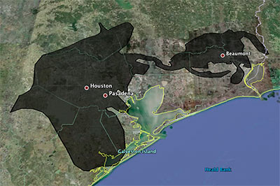
Playing around with a super-fun online tool that lets you superimpose the blobbish outline of the 2500-sq.-mile (and growing!) Gulf of Mexico oil slick from the Deepwater Horizon offshore-rig disaster onto various cities, Houstonist editor Marc Brubaker tries it on Houston — for size.

“It’s almost creepy how the slick follows I-10 out to Beaumont,” he comments. Of course, Brubaker should have nudged the oily blob a bit more to the east. Sure, he might have lost a few of those shiny exploration-company offices that have fled to the western stretches of Katy that way, but you’d be picking up lots of fun storage tanks and chug-chugging industrial plants at the northern reaches of Galveston Bay, and you’d get better coverage of Texas City, too.

Oh — but the outline is only up to date as of May 6th? Maybe we’ve got full coverage by now, then!

Image: Houstonist

05/04/10 1:34pm

COMMENT OF THE DAY: CLEARING THE AIR AROUND CLEAR LAKE CITY “As a resident of the area, I’m very interested in your comment about ‘knowing what was going on around and within Clear Lake City before Exxon developed it as a community…’ Are you aware of anything specific that might raise concerns, or is this just a baseless consumer scare?” [C.T., commenting on Comment of the Day: Clear Lake City Cleans Up Nicely]

04/20/10 3:22pm

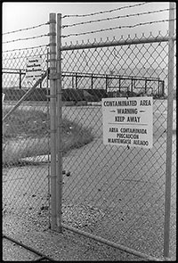
HOW TO PREPARE SAN JAC RIVER STEW What’s the local recipe for that San Jacinto River fishin’ favorite, toxic redfish? “The dioxins come from submerged waste pits north of the Interstate 10 bridge. McGinnes Industrial Maintenance Corp., which is no longer in business, owned and operated the pits in the 1960s, filling a 20-acre site on dry land with waste from a now-closed paper mill near the Washburn Tunnel. In the bleaching process, paper mills generated large amounts of dioxins, a family of compounds so toxic that scientists measure them in trillionths of a gram. The EPA says there is no safe level of exposure to the chemicals, which are known to cause cancer and disrupt immune and reproductive systems. The San Jacinto River began to run through the waste pits by the early 1970s because of subsidence — the sinking of soft soils as water is pumped from underground. With the McGinnes pits under water, the dioxins spread into the river and worked their way through the ecosystem, becoming more concentrated at each step in the food chain. For more than a decade, the Texas Department of Health has warned that fish and crab caught along this stretch of water, north of the Lynchburg Ferry, are tainted with cancer-causing dioxin, pesticides and PCBs. . . . In July, the EPA identified the International Paper Co. and McGinnes, which became part of Waste Management through a series of mergers and acquisitions, as the firms responsible for the dioxins problem. Under the Superfund law, the two companies will be required to evaluate and clean up the contamination. They paid about $65,000 for the fencing and roughly 50 warning signs in English, Spanish and Vietnamese, a McGinnes spokesman said.” [Houston Chronicle]

12/02/09 3:05pm

COMMENT OF THE DAY: THE UNCHARTED INNER LOOP “. . . you really haven’t got a clue if you think that suburban soil toxicity is a good reason to live inside the loop. The oldest parts of the city experienced the longest duration of industrial activity prior even to the creation of the EPA, much less even an understanding of what chemical agents were toxic. Check out the EPA’s EnviroMapper applet for an account of all known toxic waste sites (you’ll be amazed at the number), and even then bear in mind that that information is far from complete because there’s no telling what kind of crud was being mindlessly dumped on bare earth way back when and never reported. The Inner Loop isn’t supplied with well water anymore, so the toxic soils below us fortunately aren’t much of a problem…but that redeeming characteristic is shared by most of the City of Houston. The municipal water supply certainly doesn’t just abruptly stop all at once at the 610 Loop.” [TheNiche, commenting on My Toxic Houston Childhood]

11/30/09 5:35pm

Blogger Maritza Valle grew up in Southbend, next to the Brio Superfund site, just west of San Jacinto College’s South Campus:

I lived in a toxic waste dump when I was young.

Yes, let it sink in like the waste sank into our ground and somehow contaminated the water.

When I was young, I can’t remember how young, my mother and I moved in with Gamma, my maternal grandmother. Maybe I was about 7 because my brother was there too.  I still remember the address: 11606 South Arbor, Houston Texas 77089. It was a subdivision, pretty new, with a nice school just around the block, and our house had a back yard opposite a huge field. Every once in a while, men in weird space-suit looking outfits would come out and mess around with the ground, which concerned me because there were cows out there, and then leave. . . .

CONTINUE READING THIS STORY

08/26/09 2:42pm

ANOTHER RIVER RUNS THROUGH BAYTOWN Oil spill on the bayou: “The spill spread from an oil storage tank in the Mont Belvieu area, leaking into Smith Gully then on to Cedar Bayou. Mont Belvieu’s Emergency Management Chief Bruce Oliphant said best estimates put the spilled oil at 200 to 300 gallons but said a reason for the leak had not been determined by Tuesday afternoon. ‘We’re not sure why it leaked,’ Oliphant said. ‘We couldn’t see where it was coming from the tank and maybe it was coming from somewhere underground.’” [Baytown Sun]

06/03/09 2:00pm

WEST U TREATMENT: NOW EVEN MORE SAFE AND SMELLY Noticing anything different about the area around Brays Bayou and Kirby Dr.? “‘It smells like raw sewage,’ said [nearby homeowner Hector] Caram. ‘That’s what it smells like.’ Last month, the city of West University Place cut down the thick crop of trees surrounding its sewage treatment plant on Kirby and North Braeswood within Houston city limits. And for neighbors who live, work or jog around there, the difference is jarring. “You noticed it right away,” said jogger Lauren Cozad. ‘You said, “Oh, why’d they take those trees down,” because we didn’t even know there was anything back there.’ But West University Public Works Director Chris Peifer says his city didn’t have a choice. ‘It is a secure facility,’ said Peifer. Peiffer told us the state ordered the city to clear the fence line here and increase visibility, so security guards can more easily spot anyone trying to break in there. He says it’s a matter of homeland security.” [abc13] Update: As commenter Carol notes below, the Chronicle has more on the story here.