05/04/16 10:30am

Plan for Ivy District, Pearland, TX, 77583

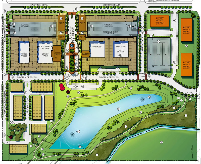
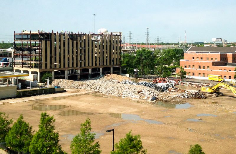
Ralph Bivins tells Swamplot that lots of dirt is being shoved around on the foreclosed former site of the WaterLights District project, west of 288 and just south of the Beltway where all those heads of former heads of state used to hang out. Pearland’s Ivy District is now being planted on the site instead: plans for the $300-million development include a multifamily complex, condos, a senior living community, townhomes, office buildings, and room for retail.

Part of the project’s funding will come from the EB-5 visa program, which allows wealthy foreigners and their immediate families to immigrate to the US in exchange for a necessary investment expected to create at least 10 jobs. Sueba USA and Beijing-owned American Modern Green are developing the site; American Modern’s parent company Modern Land of China has worked on projects in China (including Steve Holl’s twisty Linked Hybrid in Beijing) and Vancouver, but the Ivy District is its first US venture.

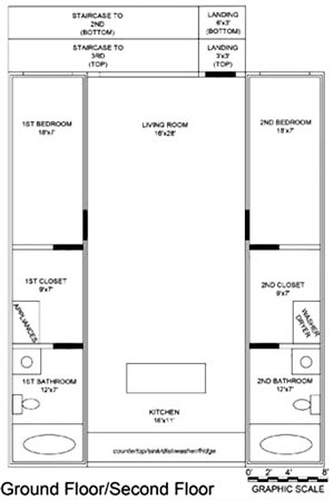
American Modern Green bought the land straddling the Harris-Brazoria county line back in late 2012 following the 2010 foreclosure. Here’s the breakdown of what will go where, per the current plans on the Ivy District’s website:

CONTINUE READING THIS STORY

Planting in Pearland
05/03/16 4:30pm

A set of 4 new FEMA disaster recovery centers opened yesterday, sprinkled around the north and west sides of Houston hit hardest by the Tax Day flooding. The locations include a Greenspoint office building right across Greens Bayou from some of the apartment complexes evacuated during the flooding (including Arbor Court). The other centers opened Monday in Meyerland, Cypress, and Spring, and additional temporary help centers might get set up elsewhere around town.

As of yesterday night, FEMA had already received nearly 12,000 applications for post-flood assistance. Harris County reported last week that more than twice as many homes were damaged by the April floods as reported during last year’s Memorial Day flooding. Farmers Insurance agent Peter Zografos told the Houston Press last week that many of the same houses have filed claims a second time: “Some of these homeowners may have to be insured directly with the National Flood Insurance Program due to repetitive claims, [and] basically will be charged more for too many flood claims.”

Map of FEMA disaster recovery centers: City of Houston

Still Under Water
05/03/16 1:00pm

Proposed Changes to Major Thoroughfare Plan near 290 beyond Grand Pkwy.

If you missed yesterday’s meeting in Hockley, you have until Wednesday to send Harris County your thoughts on the map above, from the official county study of road network expansion proposed between I-10 and 290 west of the Grand Pkwy. The thick red dashes mark a proposed loop road circling around almost the entirety of the Katy Prairie Conservancy‘s land preserve (shown as the darkest green blocks, amid slightly-grayer-green agricultural/undeveloped land and a few kelly-green public parks). Purple dashes show the proposed routes of new or expanded thoroughfares, some of which cut through the preserve and cross through the Cypress Creek floodway (shown as a blue underlay making a rough U through the conservancy’s land).

Further west (marked in blue dashes) is the not-yet-planned-but-still-showing-up-in-planning-maps route of Houston’s proposed outer-outer-outer loop, SH 36A (formerly nicknamed the Prairie Parkway). The map above also includes overlays of Harris County’s future development predictions, with dark taupe showing existing development and slightly lighter taupe showing expected expansion.

For comparison, here’s the Katy Prairie Conservancy’s map of west Houston; currently developed areas are marked in gray, the organization’s protected areas are marked in green, and the dashed green band shows how far the prairie ecosystem used to extend:

CONTINUE READING THIS STORY

Up the Watershed
05/03/16 10:30am

MFAH Stickers at Fannin at Montrose, Museum District, Houston, 77005

A reader sends a few shots of a developing piece along Fannin St. composed of traffic signal poles and discarded Museum of Fine Arts visitor stickers. The section above can be viewed from the intersection of Fannin with Montrose Blvd. (just south of the Mecom Fountain near the name change to Hermann Park Dr.) To the southwest lies Hermann Park’s Grand Gateway corridor (the string of light-rail-divided esplanades that started getting jazzed up as part of Hermann Park Conservancy’s 100th birthday present to the space); the landscaped strip runs directly north-south from the fountain roundabout to the Sam Houston statue.

Poles in the vicinity have been accumulating stickers since at least 2013. Here are a few more artsy angles on the scene:

CONTINUE READING THIS STORY

Stuck in the Museum District
05/02/16 4:45pm

1818 N Shepherd Dr, Houston Heights, Houston, TX 77008

A reader sends the latest from the corner of 19th St. and N. Shepherd Dr., where the facade of the former Mr. Pro Lube and Tune-Up Plus building is now fully swapped out with fresh Take 5 Oil Change logos and exterior branding. The shop is across the street from almost-ready-to-open Dallas pizza import Cane Rosso, and catty-corner to Fat Cat Creamery and its strip-center companions.

Below is a snapshot of what the corner looked like back in 2013 before the trade-out began — and before the space on the corner north across 19th st. changed over from Art & Showcase Flooring to Heights Retreat Salon & Spa:

CONTINUE READING THIS STORY

Strip Center Tune-Up
05/02/16 12:30pm

7204 Mchenry St., Golfcrest, Houston, 77087

On the corner of McHenry and Carothers streets in Golfcrest, a reader notes both ongoing construction and its increasingly complex backdrop: “They’ve put up walls around [the site], probably for security, but they’ve been dressing up these walls . . . I’m pretty sure that pink door trim is made of vinyl.” County records show that the property (west of Telephone Rd. and south of the South Loop) was sold in February of last year; permits have since been issued related to a remodel and add-on to the 1941 home.

Photo: Tuco Ramirez

Now in Technicolor
05/02/16 11:00am

Lowell St. Market Plans, 718 W. 18th St., Houston Heights, Houston, 77008

Some renderings and potential site plans for a retail redo of 3 warehouses at the southwest corner of W. 18th St. and N. Shepherd Dr. make an appearance in the current leasing listing for the property. Preliminary plans for the development, to be called Lowell St. Market after a former name of N. Shepherd Dr., show a greened-and-glassed-up version of the Savvi Commercial Furniture warehouse (above on the left), with a matching redo of the Airmakers Cooling & Heating building (visible on the far right).

The flier bears the logo of Radom Capital, which is a partner in the Heights Mercantile development on 7th St. Radom is also behind the pink-and-white redo of the former Heights Plaza shopping center on E. 20th, which Steel City Popsicles told Eater they’d be ready to move into some time this month. Plans for the Lowell center are still a ways off, however; the leasing flier gives summer 2017 as an estimated construction start date, but also mentions that sale or leasing of the whole property as-is isn’t off the table.

The 3 structures currently on the site add up to 20,380 sq.ft. of space; the redevelopment would scoot some of that space around and pare it that down to 10,000 sq.ft., making room for a parking lot in the back. Here’s what the footprint could look like following that trim-down:

CONTINUE READING THIS STORY

Lowell St. Market
04/29/16 5:00pm

Yale St. Bridge bricks being removed, Yale St. at I-10, Heights, Houston, 77007

An indiegogo page has just been launched to crowdfund the removal and reuse of an unexpectedly large group of well-preserved 1930s bricks from the now-under-deconstruction Yale St. bridge over White Oak Bayou. The group calling itself Friends of Houston’s Yale Bridge Bricks says the funds will be used to preserve the bricks for reuse both around the bridge and elsewhere around the city.

The fundraising effort shares some organizers with Friends of the Fountain, which launched the late-February campaign to crowdfund the de-restoration and subsequent repair of the Mecom Fountain following its short-lived experiment with limestone couture. That effort raised more than $50,000 toward a $60k goal in one month; Bill Baldwin (of both Friends groups) says it the fountain’s fundraiser received over $100k in total, including offline donations. This latest round of online crowdfunding the preservation of National Register of Historic Places structures is starting the bar higher, with a goal of $100,000 shown on the fundraising page.

Photo of work on Yale St. Bridge and Memorial Park Mattress Firm: Friends of Houston’s Yale Bridge Bricks

Follow the Yale Brick Road
04/29/16 3:45pm

3622 Lehall St., South Union, Houston, 77021

3802 Lehall St., South Union, Houston, 77021The front is up on the shipping-container-containing duplex under construction now at 3622 Lehall St. between Tierwester and Scott. The box-based structure is similar to builder Krieger Containers’s first such project (down the street at 3802 Lehall); both buildings consist of 2 separate 2-bed 2-bath units framed around 2 steel containers each. The company claims on its website that the model can beat ‘any general contractor in Houston’ on a cost-per-sq.-ft. basis.

Back in September, company founder and steel box aficionado Sean Krieger spoke with Nancy Sarnoff about plans to built dozens more container houses in the South Union neighborhood over the next few years, aiming to draw students and young professionals. Krieger now tells ABC13 that the project underway at 3622 Lehall has faced abnormal scrutiny from city inspectors and officials, recently including a heated verbal exchange on site with District D councilman Dwight Boykins (who also spoke to ABC13 about the incident after Krieger sent them a recording).

The floorplan above shows the layout of the downstairs unit of completed 3802 Lehall; the bathrooms, bedrooms, and closets fit within the footprint of the shipping containers, which flank a central living space. Here are some shots of the inside, both during and after construction:

CONTINUE READING THIS STORY

Checking All the Boxes
04/28/16 4:15pm

Proposed Prairie Tunnel Map, per Theater Square lawsuit filings

What led up to the neighborly lawsuit filed last week over the former Houston Chronicle building’s planned demolition? A pair of letters filed with the county clerk’s office as part of the suit sheds a little light on the back-and-forth between the building’s new owners and their new neighbors. Plaintiff Theater Square, a partnership controlled by construction and development firm Linbeck, is developing the downtown block marked SITE in the map above, immediately across Prairie St. from the former Chronicle property (bought last year by Hines entity Block 58 Investors). Theater Square wants to link its own could-be-a-Class-A-contender block into the Downtown tunnel network (traced above in solid black).

The company sued both Hines and Chronicle owner Hearst News last week to stop the demo, claiming that Hearst gave it property rights to build a new tunnel through the newspaper building’s basement (via the route shown in stripes above along Travis St.) and that the demo (as currently intended) interferes with that plan. Theater Square sent a letter to Hines on April 15th citing news stories about the impending demo and requesting both access to inspect the basement and assurances that the demolition would be carried out in a way that doesn’t harm certain existing structures that the new tunnel’s already-semi-permitted building plans depend on.

CONTINUE READING THIS STORY

Fight For The Right To Tunnel
04/28/16 11:30am

Former 59 Diner, 3801 Farnham St,, Upper Kirby, Houston, 77098

The original Shepherd-side
location of 59 Diner is now up for lease, with teal-and-bubblegum exterior still intact. The whole 59 chain shut down suddenly at the end of February, amid a tangle of formal and informal disputes regarding employee pay. The listing indicates that the 6,000-sq.-ft. building (officially located at 3801 Farnham St.) can be divided, as long as the future tenant wants at least 2,000 ft.

The ex-diner property is next door to the smaller building now housing The Halal Guys, whose red-and-yellow striped canopy is visible on the right in the east-facing photo above. The former carwash reopened as the New-York-food-cart-gone-international-chain’s first Texas location a few weeks before the 59 closures; hundreds of customers lined up outside the tiny venue during the opening weekend rush, some allegedly filling 59’s parking lot while waiting for hours for gyros and chicken.

Photo: LoopNet

Upper Kirby
04/28/16 10:15am

3606 Bissonnet St., Greenway/Upper Kirby, Houston, 77005

Construction fencing is already up around the Cleburne Cafeteria, which burned down for the second time at 3606 Bissonnet St. earlier this week. The 75-year-old cafeteria business was bought by Nick and Pat Mickelis in 1952 at its original location on Cleburne and Fannin streets (which was recently occupied by DiverseWorks for a brief pre-MATCH stint, and currently houses the Zoya Tommy art gallery). The cafeteria moved to the Bissonnet spot in 1969; shortly after Nick Mickelis’s death in 1989, the building burned down for the first time.

CONTINUE READING THIS STORY

Restaurant Re-Reconstruction
04/27/16 4:45pm

Corporate Plaza I Demolition, 2600 Kirby Dr., Upper Kirby, Houston, 77098

That’s 2 stories down and 8 left to go for the last holdout in the former Corporate Plaza office park, seen here from the northeast looking across Kirby Dr. toward 59. The freeway-facing and side facades of the once-10-story midrise have been totally removed, and the remaining facade is beginning to look a bit patchy around the top; piles of debris can be seen stretching out to the north of the structure, across the now-barren Upper Kirby plain where the partially demolished Corporate Plaza parking garage nearly demolished part of the demo team back in February.

Photo: Lulu

Office-Appropriate Cut on Kirby
04/27/16 3:45pm

All the little red dots above show storefront retail locations throughout the Houston area. The map comes from Portland-based City Observatory, which just released a shiny new report on using the number and arrangement of customer-facing businesses to guide city planning. The bar in the top left corner lets you jump around between Houston and the 50 other cities mapped by the project.

Like the other studied towns, Houston is shown with a black ring marking off a 3-mile radius around Downtown. A closer look at Downtown shows a sharp divide in storefront density across the Main St. corridor: 
CONTINUE READING THIS STORY

Marking the Market
04/27/16 11:30am

Barker Clodine Rd. in Barker Reservoir, Houston, 77084

A reader caught the view above during a lunchtime bike ride into the Barker reservoir yesterday. The shot shows the nearly submerged stop signs on the currently-closed road barricade where Barker Clodine Rd. merges into the hike-and-bike trail system running throughout much of the reservoir (which stretches between I-10 and the Westpark Tollway just west of Hwy. 6). The Corps of Engineers has been releasing water from both Barker dam and its sister reservoir Addicks across I-10 since Thursday — but the level behind the dams continued to rise for a few days as additional water drained into the basins from the surrounding watersheds, faster than that water could be safely released downstream into Buffalo Bayou.

Both Barker and Addicks reservoirs’ levels finally began dropping on Saturday — though both started filling again briefly on Sunday as water from later-in-the-week storms trickled east from the surrounding watersheds. Below is an up-to-date look at Barker reservoir’s change in storage since the Tax Day flood, per USGS measurements:

CONTINUE READING THIS STORY

Addicks and Barker