YES, YOU’VE BEEN SIPPING WHAT DALLAS HAS BEEN FLUSHING 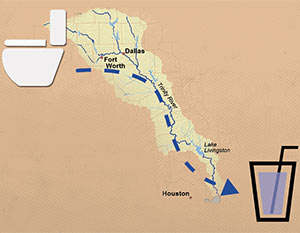 “For the large chunk of population that lives downstream from a big city and whose water supply flows through a river, more than a few drops of the water in their glasses was probably once in someone else’s toilet,” Neena Satija drily notes in her reassuring survey for the Texas Tribune of sewage-treatment projects throughout the state. Her story is worth checking out for the animated image diagramming the flow from a Fort Worth-area toilet to a Houston highball glass alone (excerpted screenshot shown at left, above), but she does stir up some oft-repeated local poop: “Let’s start with Houston, which, as Texas State University professor Andy Sansom says, ‘has been drinking Dallas’ crap for decades,’” she writes. “Wastewater from Dallas and Fort Worth is deposited into the Trinity River, where it flows down into the lakes that supply Houston residents. The wastewater is so clean that it’s credited with helping the Trinity River stay strong during recent years of severe drought.” [Texas Tribune; previously on Swamplot] Illustration: Todd Wiseman/Alessandro Suraci/Luis Prado
Bayous and Waterways
A spokesman says the Houston Police Department has “long been aware” of most of the 127 vehicles Texas Equusearch found submerged in Houston bayous back in 2011, when the nonprofit search-and-rescue organization used a sonar-equipped boat to hunt for the rented car of an elderly woman who had gone missing. But until Equusearch went public with the data this week, it appears no one from law enforcement had bothered to bring the rusting cars and trucks to the attention of environmental organizations, families of missing persons, wrecker drivers, classic-car collectors and restorers, bayou boaters, noodlers, or other groups that might have wanted to know.
No matter, now: Above, courtesy of Texas Equusearch and the Houston Chronicle, is an interactive map identifying the coordinates and descriptions of the vehicles — including at least one full big rig — that have been gently rusting at or near the bottom of Brays and Sims Bayous for at least 2 and a half years. The Chronicle data appears to exclude the half-dozen or so transportation options Equusearch searchers found beneath the waters of the relatively un-trafficked Buffalo Bayou. But you can spot some of them in the upper portion of this screen capture published with Joel Eisenbaum’s original report for KPRC of a similar map:
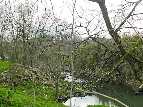
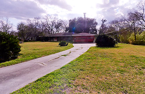
Little White Oak Bayou meanders by the back of a property (and so do a couple of uh, hikers in the background of the top photo) located east of N. Main St. and about 3 sidewalk-lined blocks from the Metro rail station at Fulton St. Is the Northside property located in De Noyles, as indicated in the listing, or is it Booth North Main, as recorded by HCAD for all addresses on the block? The listing’s all-cap message is all about redeveloping the acre-plus lot of land, not the 1960 home that sits on it at the end of a long driveway (above). A month ago, the asking price dropped to $1.1 million. Since January (and in a previous listing dating back to September 2013) it had been sitting at $1.6 million. But even that was down a bit from someone’s expectations: In 2008, a six-month listing’s asking price kicked off at $2 million.
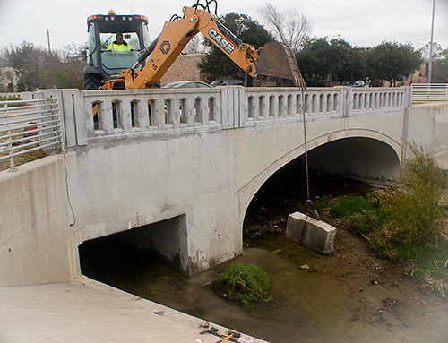
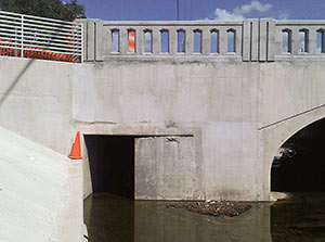 . . . Well, at least as long as Brays Bayou is able to handle whatever rains come. Late last month, an excavator (pictured above) yanked out the last piece of a 3-year-old 6-ft.-by-6-ft. concrete panel used as a “restrictor” and meant to make sure rainwater that fell in West U stayed in West U for a good long time. The restrictor (shown in place blocking the right side of the drainage channel pictured at left) had been put in place by the Harris County Flood Control District after West U, working with the city of Southside Place and Metro, completed $8 million worth of drainage improvements in 2010 on the colorfully named Poor Farm Ditch, which drains along the east side of Edloe St. through much of West University and further south to Brays Bayou. Those improvements had been meant to solve West U’s frequent flooding problems. But without some place for the water to go, that solution for West U might have caused flooding elsewhere downstream. So the district placed the restrictor on Poor Farm Ditch on the south side of the Edloe St. bridge across Holcombe St. — until the city could somehow come up with 13.5 acre-ft. of flood detention to hold the runoff.
With flood improvements completed but the restrictor still causing water to back up on Poor Farm Ditch, West U flooded again in January 2012 after a hard rain.
WHERE THE POOP IS, IN AND AROUND LAKE HOUSTON 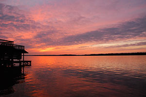 “While some Houston bayous, such as Buffalo and White Oak, have bacteria levels seven times higher than Lake Houston’s watershed, the waters flowing from the San Jacinto River are more vital, said Steve Hupp, Bayou Preservation Association spokesman. . . . Houston’s drinking water is pumped from an area of the lake not contaminated with bacteria.
Only the northwest corner of the lake is impaired, records show. This segment runs from where the river intersects Spring Creek, winds through Humble and past the Kingwood golf course, and ends at the West Lake Houston Parkway bridge.
The bacteria level found in the lake segment exceeds the state standard of 126 E. coli per 100 milliliters of water by 100 percent. Levels on both the river’s west or east forks are lower — exceeding the standard by 25 percent to 56 percent, depending on the segment. Yet a small tributary, Crystal Creek, which feeds into the west fork, has the highest count. It exceeds the state standard by 168 percent.
The communities along the San Jacinto watershed are experiencing a boom in development, especially around the river’s west fork in Montgomery County. Exxon Mobil already has a new 385-acre corporate campus that will be home to 10,000 workers under construction there, while the Boy Scouts recently sold their nearby 2,175-acre camp to a master-planned community developer for a reported $60 million.” [Houston Chronicle ($)] Photo of Lake Houston: Sara Robertson (license)
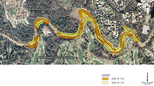
in this week’s Houston Press, writer Dianna Wray wades into the murky waters surrounding the Harris County Flood Control District’s plan to move and rebuild the banks of Buffalo Bayou where it winds between Memorial Park and the River Oaks Country Club. The method of “natural channel design” the district plans to use in the $6 million project is meant to keep the bayou in place, using downed trees instead of concrete. But weren’t bayous born to wiggle? “If the Army Corps of Engineers approves the Memorial Park Demonstration Project permit application,” Wray writes, “construction workers could move in by the end of this year, using heavy equipment and saws to reshape the bayou according to a pattern that should, if the method is successful, lock the waterway into a form it will hold for generations to come. If the effort fails, the entire project could be blown down the river by one heavy flood, leaving nothing but naked, unprotected soil where the last of an ancient forest once stood.”
- Fighting for Control: Can Buffalo Bayou Survive the Latest Plan to Save It? [Houston Press]
- Conservationists have an eye turned to Buffalo Bayou project [Houston Chronicle ($)]
- Memorial Park Demonstration Project [HCFCD]
Plan of Memorial Park Demonstration Project: Harris County Flood Control District
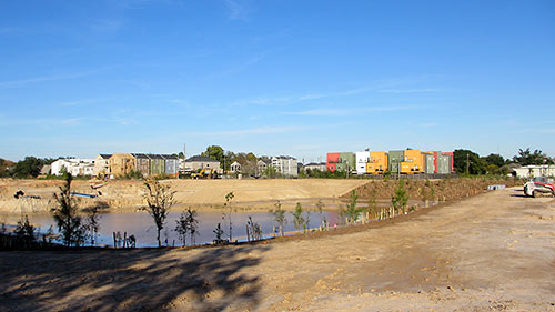
A reader sends in pics showing how construction is progressing on the 3 retention ponds along White Oak Bayou TxDOT is building between Yale and Shepherd — and hoping to trade them for any available updates about plans for the adjacent segment of the planned bayou-side path: “Looks like they are making progress with tree planting and installation of pavers on the slopes. They have left a wide swath of level ground around the entire perimeter. They are still doing earthwork on the north end, and it looks like they still need to excavate more soil from the center pond, but you can make your way around all three detention ponds.”
The photo at top shows the center pond (south of the bayou), looking northeast, with White Oak Bayou barely visible off to the lower right. Below, a view of the northernmost piece, Rutland Pond, a portion of which interrupts 6th St. (where the orange construction fencing is visible):
COMMENT OF THE DAY: THE BETTER LAKE  “Wrong lake? Would you prefer rush hour on Lake Conroe? Shoulder to shoulder and all the noise?
The area of Lake Livingston is 129.7 sq miles compared to Lake Conroe of 32.81 sq miles. Four times as large.
Lake Livingston is fed from the Trinity River which flows from North of Dallas (almost Red River / Oklahoma line) while Lake Conroe is fed from the West Fork of the San Jacinto River. This matters greatly if it doesn’t rain or if Houston is too thirsty.
Avg depth in Lake Livingston is 55 feet compared to 20.5 feet for Lake Conroe.
In short Lake Livingston is far less congested, four times as large, much more stable water level, and much deeper. You choose but I chose Lake Livingston and love every minute of it and don’t forget the ability to head up the Trinity River a long long ways for other large bodies of water and calm surfaces for wake boarding and water skiing.” [Scharpe, commenting on A Newish Lakeside Estate in Coldspring Looks Back] Illustration: Lulu
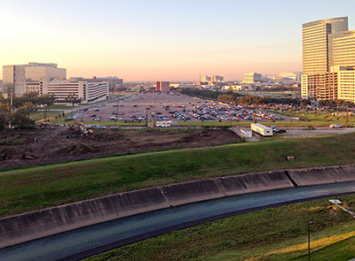
And here, from a reader perched at the top level of MD Anderson’s Braeswood Garage at Braeswood Blvd. and Pressler St., are photos of the land- and tree-clearing going on for the new just-across-the-bayou-from-the-Med Center apartments that Mill Creek Residential is going ahead with — after abandoning plans for a slightly larger complex (as close as it could get to Dynamo Stadium without crossing Dowling) in East Downtown. The photos are taken looking south, over Brays Bayou; the TMC South Extension Lot is behind the site, which fronts Wyndale.
COMMENT OF THE DAY RUNNER-UP: AFTER THE BAYOU FLOODS  “I’ve been riding the trail along the Bayou for 6 years and I’d say the flood debris problem has been greatly reduced of late. That might just be a result of the drought, but certainly the city has been quicker to send crews with fire hoses to wash the trail after floods.
Some part of me misses the mess, though . . . I knew where the debris would tend to accumulate after a period of high water and developed affectionate nicknames for each patch.
Why, I’d whistle as I passed through dysentery ditch, and marvel at cholera canyon. But MRSA meadows, now that was some goop, I tell ya . . .” [Patrick, commenting on Lookee What the Kinder Foundation’s $50M Is Gonna Help Build Along the Bayous] Illustration: Lulu

Here’s a rendering that shows how that informal dog bowl along Buffalo Bayou near Montrose Blvd. will be formalized and capitalized into a Dog Park. Construction, says a PR rep for the Buffalo Bayou Partnership, will begin the first of the year; the park should be open next winter.
Why, you might wonder, would it take that long to build a place for dogs to romp and run and bark and stuff? Part of it will be creating the pond you can see in the rendering. The pond, which will be treated with a “bio-filter” and native vegetation, is meant to keep said dogs 1) safe and 2) away from the bayou, so they don’t muddy up the banks scrambling in and out of the water and contribute to erosion. Other additions? A purty fence that will separate the pups from the joggers and 2 pavilions, at the top of the hill, that will provide a bit more shade.
- Previously on Swamplot: What’s Been Happening at Buffalo Bayou Park, Introducing the Bud Light Amphitheater, the Next Greenspace To Grace Buffalo Bayou, How To Build a Buffalo Bayou Pedestrian Bridge: A Photo Tutorial, The Next New Bridge Going over the Bayou, More Pedestrian Bridges and Other Twists and Turns in the Plans for Buffalo Bayou Park
Rendering: SWA Group

So the city has agreed to hand over maintenance of all the new bayou trails ’n’ stuff to the Houston Parks Board — it was the one condition that the Kinder Foundation stipulated before it would agree to donate $50 million to the Bayou Greenways project. That donation became a done deal earlier today. This dough, says the Parks Board, is going to allow construction to begin before the end of 2014 on as many as 14 new sections of trail — including even more work along Brays Bayou in Mason Park in the East End, shown in this rendering from SWA Group.
THE CATCH IN KINDER FOUNDATION’S BAYOU GREENWAYS CASH GIVEAWAY  It’s one thing to get the money to build a bunch of nice parks, and it’s another to keep them nice: Houston Chronicle reports that the Kinder Foundation isn’t convinced that the city will be able to pay for the maintenance of all those miles and miles of hike and bike trails and linear parks it’s setting up through the Bayou Greenways Project. That’s why — before the foundation agrees to donate the $50 million it’s dangling out there to the project — it wants the nonprofit Houston Parks Board to be put in charge of future upkeep: “Under the proposed arrangement, the city agrees to pay the park board up to $10 million a year for maintenance. Although the nonprofit likely will hire private companies and Harris County Flood Control to do some work, the city parks department would be the preferred contractor for the bulk of it, essentially bringing much of the funding back to city coffers. Additionally, the agreement includes an annual 20 percent contingency fund the board can use for capital improvement projects, such as installing new lights or replacing aging trails, or for disaster recovery after flooding or hurricanes.” [Houston Chronicle ($); previously on Swamplot] Photo of hike and bike trail construction on Brays Bayou: Allyn West
BUILDING A MONUMENT TO GATED FLOOD CONTROL AND TOURISM  Protecting the Ship Channel during an Ike-like (or worse) storm surge has led some to propose a big dike, others a big gate. But UH professor of urban planning Tom Colbert doesn’t see why we couldn’t trouble ourselves to make such protection a real sight to see too: “Colbert likes the idea of . . . connecting the Centennial Gate and its levees to the proposed Lone Star National Recreation Area, undeveloped land that would both attract ecotourists and slow floodwaters,” reports the Houston Chronicle’s Lisa Gray: “I remembered one drawing I’d seen in [Colbert’s] PowerPoint show: Happy tourists, paddling kayaks past the Hartman Bridge, on one of the byways out of the big ships’ path, waterbirds and wetlands all around. Colbert motioned southeast, toward the Ship Channel’s mouth, toward Barbours Cut, the other possible location for the floodgate. There, he said, the levees would cross the channel’s water, connecting the Ship Channel’s artificial islands — made from dirt dredged from the channel — to the shore. Enough room could be left on top of the levee for a hiking path or even for car access; for the first time, it would be possible for people to get to the Atkinson Island Wildlife Management Area — a bird mecca on manmade land — without a boat. You could even, he notes, build a tourist destination atop one of those islands: He proposes a monument to Houston, the gateway to North America, the place where nature meets industry. In some drawings, just to give people the idea, he plunks the Statue of Liberty atop a Ship Channel island.” [Houston Chronicle ($); previously on Swamplot] Photo of Fred Hartman Bridge: Chuck Wilkson
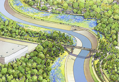
Construction began yesterday on a new 1.35-mile segment of hike and bike trail on White Oak Bayou, the first of 5 planned sections that will more or less formalize the route that some trail users have taken it upon themselves to blaze. Eventually, the $3.4 million that the Bayou Greenways project will spend here will create about 11 miles of off-street passage from Hollister Rd. in Spring Branch to Downtown.
But first things first: This new segment will span Shepherd and Durham and W. 11th St., where, as this rendering from SWA Group shows, that charred MKT railroad trestle will be replaced with a snazzy new one — somewhat to the chagrin of John Nova Lomax, you’ll remember, who’s on the record lamenting the yoga dads and their ilk that that char might have once scared off.
- Previously on Swamplot: Fearing the Yoga Dads the New Heights Hike and Bike Link Will Bring, Off-Trailing with Houston’s Northwest Bike Path Pioneers, Parks By You’s Feel-Good Campaign To Build More Bayou Parks by You, Enormous Plan To Build Bayou-Side Parks: The Movie
Rendering: SWA Group

