PICKING THE TEXAS T-BONE: NOT NUMBER ONE WITH THAT BULLET Texas may be way behind other states vying for chunks of the $8 billion in stimulus money the feds are handing out for high-speed rail projects, but it’s getting in line: “Texas is asking for $1.7 billion to speed development of a super-fast passenger train linking Dallas to Austin to San Antonio, and with a spur to Houston. Federal guidelines for the funds make it unlikely that such a big amount will be awarded to Texas, given how little preliminary work — such as environmental studies, feasibility reviews or right of way acquisition — has been done on the bullet train proposal. Still, TxDOT spokeswoman Karen Amacker said today, “it never hurts to ask,” and noted that the guidelines for the grants released in June are themselves in draft form. . . . [U.S. Secretary of Transportation Ray] LaHood said even states, like Texas, who have so far done little to advance high-speed passenger rail will be considered for the grants.” [Transportation Blog, via Off the Kuff]
Tag: Transportation
CROSSING THAT THIN BABY BLUE LINE Two Bellaire City Council members are upset about a very long, baby blue line Metro painted along Bellaire Blvd. last month: “‘We work hard in Bellaire to improve the look of our community, the planning commission is working hard on a comprehensive plan, and then some outside entity decides to paint a stripe down our street, and I don’t like it,’ said Councilmember Peggy Faulk at Monday night’s council meeting. ‘We are continually plagued by visual pollution,’ said Councilmember Pat McLaughlan, who also challenged signs posted at-will by government jurisdictions through Bellaire. Metro painted the blue line along the entire route of its Quickline Signature express service, which offers high-tech hybrid buses at peak hours down Bellaire/Holcombe Boulevard from west Houston to the Texas Medical Center.” [Bellaire Examiner]
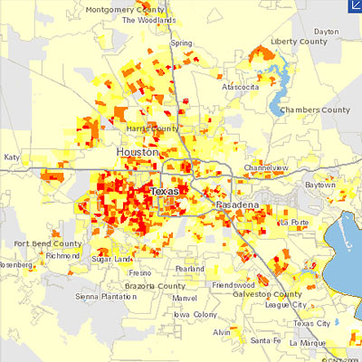
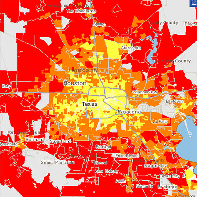
The Center for Neighborhood Technology has updated its interactive region-comparison website to show data comparing carbon dioxide emissions around the Houston region. The Housing + Transportation Affordability Index now allows you to compare CO2 emissions — from “household vehicle travel” only — on side-by-side zoomable maps.
The 2 new data sets available show CO2 emissions per acre (at the top above), and CO2 emissions per household (directly below that) from household auto use. The Houston-Galveston-Brazoria region is one of 55 U.S. metropolitan areas mapped on the website. The center’s point?
When measured on a per household basis, it found that the transportation-related emissions of people living in cities and compact neighborhoods can be nearly 70% less than those living in suburbs.
The center figures that transportation accounts for 28 percent of all greenhouse gas emissions in the U.S.
Other H+T map tools focus on how affordable different locations are to live in — when you take transportation costs into account:
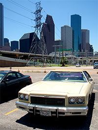 It doesn’t take long for Covenant Community Capital Corporation summer intern James M. Harrison to learn where Houston’s oldest secrets are buried:
. . . for having not known a soul in Houston 24 hours ago, I feel like maybe I’m doing decent. Part of why I feel this way is thanks to Leon, a homeless man at the Amtrak station who sat and talked to me for an hour while I waited for my ride to come.
Leon is a treasure-hunter, a “modern-day Indiana Jones.” He walked up to me and said, “I’m a rock collector, check these out” and proceeded to show me some of his latest finds. Rubies, emeralds, amethyst, and gold, so he claimed, all embedded in pieces of railroad track ballast. He didn’t want to sell them to me, because he knew that I couldn’t afford any of them. “I charge top dollar,” he said.
I asked him where the rocks came from. “The Rocky Mountain,” he said. “These stones just fall off the train when it rolls through.” He also told me about a secret mine in Colorado that he knew about called “The Gold Nugget,” and explained how he and his friend were going to go up there and excavate the largest piece of gold in the world. “It’ll fill up six railroad cars,” he said. I asked him how he was going to do it, and he replied, “I don’t know man, but two hands are better than one!”
Leon is also a hunter of dinosaur bones (“there’s a few down there in that parking lot,” he told me), 16th century books, and ancient coins, among other relics. He talked my ear off.
Leon the treasure hunter was the first person I met in Houston. I think he introduced me to the place pretty well. “Treasures are all over this city, you just have to look at what’s under your nose,” he said.
- on the ground [Neighborhood //#5]
- Covenant Community Capital Corporation
Photo of parking lot at Amtrak Station, 902 Washington Ave.: James M. Harrison

That North Main St. Intermodal Terminal planned for just north of the UH-Downtown business school has been renamed a little more humbly as Burnett Plaza, according to a note on the Metro website. And . . . it’s going to be just a little simpler than the fancy rendering shown above.
Rail watcher Christof Spieler points to a few key sentences that describe the downgrade:
The initial phase will include a half-circle on the east side of Burnett Station. There will be vertical circulation down to a 4-bay transit center with access to a “kiss and ride.”
METRO intends to construct the facility in phases, commensurate with funding and environmental clearances. Phase I transportation services will include METRORail, and local bus service, along with shuttle vans and taxis.
Spieler translates:
What this means is Phase 1 is an elevated light rail station with an elevated half-circle plaza with stairs down to a small parking lot with 4 bus bays.
- Intermodal Terminal Frequently Asked Questions [Metro Solutions]
- On the Shelf: That Grand North Main Intermodal Center [Swamplot]
Rendering: Ehrenkrantz Eckstut & Kuhn Architects

What’s the status of those plans for a big Intermodal Transit Center at North Main and Burnett just north of I-10 Downtown, meant to link commuter rail and bus lines to the coming northern reaches of Metro’s existing rail line?
L.A.’s Ehrenkrantz Eckstut & Kuhn Architects are now showing off this rendering of the terminal at the company’s website, along with the kind of encomium that usually accompanies abandoned or massively scaled-back projects. Rail-watcher Christof Spieler reported back in March that the terminal project on the North Line had been “shelved (for now, at least)”; plans to extend the new East End Line to that station were abandoned last year.
- Houston Northern Intermodal Transit Facility [Ehrenkrantz Eckstut & Kuhn Architects]
- Proposed Metro Intermodal Terminal [HAIF]
- We have (part of) a contract! [Intermodality]
- The New New Metro Rail Map: University Line Takes the Uptown Express, TSU Takes a Hike [Swamplot]
Rendering: Ehrenkrantz Eckstut & Kuhn Architects
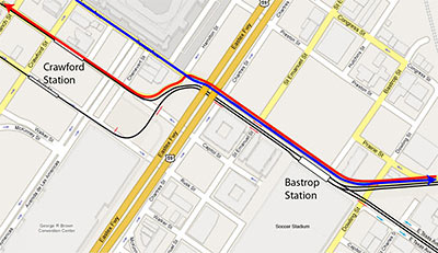
Worried the Dynamo soccer stadium planned for the superblock between Texas, Dowling, Hutchins, and Walker is gonna block traffic between Downtown and the East End? Citizen rail designer Christof Spieler solves the tangle:
There are two parts to this idea. The first is to make Texas alongside the stadium a two-way street. Instead of two eastbound traffic lanes and two light rail tracks, Texas gets two eastbound traffic lanes, two westbound traffic lanes, and two light rail tracks. That all fits in the existing right of way. The second part is to use the “squiggle†in the light rail tracks for traffic lanes as well. This does two things: it gives the westbound traffic on Texas a way to go, and it cleans up those messy intersections.
So now, to get from the East End to Downtown, you simply follow Harrisburg, which flows right into Texas, and then you make a left turn onto Capitol. And you will not hit an awkward intersection or have to cross the rail line to do it.
- Introducing the squiggle [Intermodality]
Map: Christof Spieler
Spurred on by family members waiting patiently at the Carrabba’s on Kirby — and the promotional whizzes at GM and CBS Radio, who’ve furnished her with a brand-new vehicle to drive for 8 weeks — mommy blogger and new Chevy Traverse spokesmom Stephanie Click ventures out from her “own little world” in Katy to . . . the scary and purportedly trafficky Inner Loop!
Will she make it? How will her blogger-swag loaner car stand up to the rigors of multi-lane Houston driving?
- Driving to Downtown Houston – Stephanie Click – MommyMadnessHouston.com [Vimeo]
- My New Ride … for now. [Real.Life.Mom]
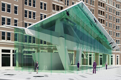
Okay, everybody out with your Regent Square renderings! HAIF’s lockmat digs up images of additional structures planned for the 15-acre North Montrose mixed-use complex, including two separate projects from the Venezuelan Miami architect Luis Pons.
What’ve we got here?
Pons’s “Regent Square Launch” looks more like a transit station than a boathouse. But who knows? Buffalo Bayou is just across Allen Parkway!
Many more pics:
Here’s a whizzy reel showing what the new Metro trains and stations on 4 upcoming light-rail lines are supposed to look like. Dowling St. in the Third Ward, the Edloe Station in Greenway Plaza, the Moody Park Station on the North Line, MacGregor Park Station on the Southeast Line, and Lockwood Station on the East End Line each get about 30 seconds of CGI treatment, from a low-flying camera buzzing some extremely lifelike — though torpid — pedestrians.
Christof Spieler finds a few flaws:
The Third Ward footage seems to be out-of-date; it shows the old alignment crossing Dowling on Wheeler, not the new route that switches to Alabama. But other details are correct: the stations shown are the new prototype station design (by Rey de la Reza Architects), minus artwork.
It’s nice to be able to visualize what these lines might look like. But it’s also a reminder that it’s important to get the details right. At Edloe, for example, the trees integrated into the canopy are nice, but there’s no crosswalk at the west end of the station platform, which means a 500-foot detour for some riders. The Moody Park and MacGregor stations do show that crosswalk, and the sidewalks look pretty good, too. But in all the images, the overhead wires are suspended from their own poles in the middle of the street, not from the streetlight poles on either side, as on Main Street. That makes for more poles and a more cluttered streetscape.
COMMENT OF THE DAY: SMALL STREET ADDITIONS TO THE GALLERIA AREA 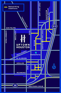 “The Uptown TIRZ and District are actively working to build a grid in Uptown. Much of it will be funded by existing and new developments by the TIRZ funds and not from the general taxpayer base. . . . [This map shows] their planned addition of grid style layout to uptown. . . . It’ll take existing private access roads and convert some to public streets.” [kjb434, commenting on Uptown Traffic Grid] Map: Uptown Houston District
MANAGING THE NEW KATY FREEWAY MANAGED LANES Those new center sorta-HOV lanes on the new Katy Freeway will go toll starting this weekend. Here’s a little primer to help you make intelligent purchase decisions at 65 mph or more: “The lanes will now be open 24 hours a day, 7 days a week. Outside of rush hours, they’re a toll road: every car, regardless of how many people are in it, pays $1.10 to go the full length of the lanes. During rush hour, in the rush hour direction, single occupant cars pay between $2.00 and $4.00 and 2+ carpools are free. Those rates will need to be adjusted if the lanes are too popular, because HCTRA (who operates the lanes) has promised METRO (who gave up the HOV lane to make room for them) that buses will keep moving at full speed. Single occupant vehicles and carpools will be sorted out by a three-lane toll plaza: left lane for carpools, right two lanes for SOVs.” [Intermodality; details]
UPTOWN TRAFFIC GRID “As we all know, traffic is incomparably worse in Uptown than it is in Downtown. Downtown has more of everything: more streets, more freeways, more transit, more pedestrian use. The most important part, though, is that Downtown has the grid, and Uptown does not. Uptown is a lot less dense than Downtown, and yet it’s reaching a breaking point. There are critically few ways in and out, and even though those are mega-roads, they concentrate traffic BY DESIGN rather than diffusing traffic as the grid does. If Uptown had a fine-grained local street grid the traffic there would be a fraction of what it is today, but it’s too late to put in a grid now. The best we can hope for is for benevolent developers to include new connecting streets to break up some of the super-blocks when they come up for redevelopment.” [NeoHouston]
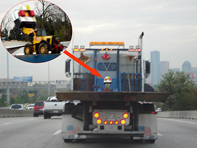
After seeing a similar scene captured by Pankaj in Swamplot’s Seen on the Street feature Monday, reader Mary Ellen Arbuckle sends in her own mini-construction-vehicle-on-flatbed photo from another freeway. This was the scene on I-45 heading south toward Downtown, just 6 days before Christmas last year.
Great real estate video takes time. Bicyclist and blogger Dave McC has been very patient:
I’ve been waiting for a year since this place was finished to time it right for a good photo op. Today was that day! Houston has some wonderful examples of Developers Gone Wild (TM). This is a great one . . .

