Sign up for the Newsletter
Tag: Utilities

HIGH VOLTAGE NEWS FOR HOUSTON BICYCLISTS  Parks and Rec department director Joe Turner tells the Chronicle‘s Mike Morris that a powerline right-of-way crossing on University of Houston property northeast of the intersection of Martin Luther King Boulevard and Old Spanish Trail will be the first improvement allowed by a new agreement between the city and CenterPoint Energy (subject to city council approval this week) that will allow hike-and-bike trails to be cut along electrical transmission-line right of ways throughout the city. Most likely the next up, according to Turner: a trail from Sims Bayou to Cambridge Village Park in southwest Houston. That route, along with others being contemplated, runs north to south. As Mayor Parker noted in her announcement, that should complement the bayou-side (and therefore mostly east-west) trails being created as part of the Bayou Greenways 2020 project. CenterPoint is donating $1.5 million toward the creation of new trails on their property, possibly because it got what it wanted in the deal, which also involves the conversion of all 165,000 city traffic signals to LEDs over the next 5 years. Writes Morris: “Bills to allow trails on utility right of way were filed as early as 2007 but stalled over questions about how much liability CenterPoint should face in opening its land for recreational use. A compromise was reached last year. The utility is liable only for a serious injury or death caused by its ‘willful or wanton acts or gross negligence.’ Under the agreement announced Friday, the city would pay the utility’s legal bills if lawsuits are filed.” [Houston Chronicle ($); more info; previously on Swamplot] Photo of bike trail along Brays Bayou: Dave Fehling/State Impact

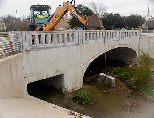
 . . . Well, at least as long as Brays Bayou is able to handle whatever rains come. Late last month, an excavator (pictured above) yanked out the last piece of a 3-year-old 6-ft.-by-6-ft. concrete panel used as a “restrictor” and meant to make sure rainwater that fell in West U stayed in West U for a good long time. The restrictor (shown in place blocking the right side of the drainage channel pictured at left) had been put in place by the Harris County Flood Control District after West U, working with the city of Southside Place and Metro, completed $8 million worth of drainage improvements in 2010 on the colorfully named Poor Farm Ditch, which drains along the east side of Edloe St. through much of West University and further south to Brays Bayou. Those improvements had been meant to solve West U’s frequent flooding problems. But without some place for the water to go, that solution for West U might have caused flooding elsewhere downstream. So the district placed the restrictor on Poor Farm Ditch on the south side of the Edloe St. bridge across Holcombe St. — until the city could somehow come up with 13.5 acre-ft. of flood detention to hold the runoff.
With flood improvements completed but the restrictor still causing water to back up on Poor Farm Ditch, West U flooded again in January 2012 after a hard rain.
The Rich Floodwaters of Poor Farm Ditch


Tweeting from low Earth orbit on board the International Space Station, NASA astronaut and Clear Lake City resident Rick Mastracchio sends out this spiderweb-like nighttime image he snapped of Houston. What’s that bright spot in the section in the lower right? “Think I left my lights on!” he writes.
Photo: Rick Mastracchio
Photographic Signs of Intelligent Nightlife

A TREESTARTER FOR MEADOWCREEK VILLAGE PARK 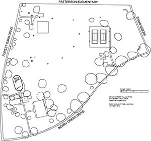 There’s no ponderous selfie video to go with the appeal (a more generic promotional vid from Trees for Houston is posted instead), but the Beautification Committee of the Meadowcreek Village Civic Club has taken to a crowdfunding site to raise money for twenty 15-gallon trees they hope to plant at drought-stricken Meadowcreek Village Park on Forest Oaks Blvd. just south of Allendale Rd. The $3,000 the committee hopes to raise from online donations won’t be going to buy the trees, however — Trees for Houston has already donated them. Instead, they’re trying to fund the trees’ watering costs for 2 years, which committee chair Joe Rocha figures will cost $75 per tree per annum. With a mere 43 days to go before the end-of-the-year watering-fund deadline, the campaign is almost a third of the way toward its goal. [YouCaring] Drawing of Meadowcreek Village Park: Beautification Committee

CALCULATING THE GREEN FOR THIS WEEKEND’S FREE TREE GIVEAWAY  Hmmmm . . . what’ll it be for your yard? Live Oak, Bald Cypress, Burr Oak, Cedar Elm, Chinkapin Oak, Drummond’s Maple, Loblolly Pine, Mexican White Oak, Nuttall Oak, Overcup Oak, Pecan, Shumard Oak or Water Oak? Come to the remote Rodeo Houston parking lot at 2030 Reed Rd. with your electric bill in hand this Saturday, October 26, between 8:30 and 3:30 and you’ll have your pick — of whatever’s left. Trees for Houston, CenterPoint Energy, and the Arbor Day Foundation will be giving away a total of 2,500 specimens in 5-gallon containers this weekend (a couple thou are still unclaimed). You can reserve yours online. A handy satellite-photo-equipped web app is meant to help you decide where to plant your tree and which species to plant; it estimates annual energy-cost savings for each type of tree, depending on where you place it on your property. [Arbor Day Foundation]

WILL POWER LINE BIKE TRAILS COME TO HARRIS COUNTY?  Approved this week and sent on to Gov. Perry was a new draft of that bill proposing bike trails along CenterPoint utility rights of way. CenterPoint didn’t seem too crazy about the first draft of the bill, saying back in February that it wouldn’t allow the trails unless it was assured it wouldn’t be liable should something shocking happen. This revised draft, the Houston Chronicle’s Mike Morris reports, covers CenterPoint all the way up to “willful or wanton acts or gross negligence.” And Morris writes that as many as 142 miles of right of way in Harris County could be available for trails if Gov. Perry signs off on the bill, many of them providing missing north-south connections between the existing trails that run primarily east-west along the bayous. (Houston Chronicle ($); previously on Swamplot) Photo: StateImpact


Thieves made off with copper wiring from UH’s University Center late Saturday night, a UH public safety department bulletin reports: A contractor noticed early Sunday morning that the wiring had gone missing; a reader tells Swamplot that this knocked out the building’s power and is delaying renovations. The Barnes & Noble and Cougar Byte stores inside the UC have been scrambling to set up temporary locations elsewhere on campus.

CENTERPOINT SAYS NO BIKE TRAILS WITHOUT ‘ADDITIONAL LIABILITY PROTECTION’ Houston lawmakers Sarah Davis and Jim Murphy have each introduced a bill to the state legislature that would have more bike trails built here along CenterPoint-owned utility rights-of-way, but the energy provider’s response seems to StateImpact reporter Dave Fehling a little overprotective: “a CenterPoint media liaison said it would permit trails ‘if — and only if — the Texas Legislature provides additional liability protection to CenterPoint from people entering its rights of way.'” Fehling adds: “What has resulted, though, are bills that would give what lawyers say is almost blanket immunity to CenterPoint Energy should someone get hurt on company property while using it for recreation, even if CenterPoint was ‘grossly negligent.’†[StateImpact; previously on Swamplot] Photo: StateImpact

IF YOU TYPED ‘POTHOLE,’ PLEASE TYPE ‘YES’  A spurting water main? One of your neighbor’s free-range hens clucking the ever-loving night away? There’s an app for that: today, the city is launching a 311 app that will help smartphone-equipped Houstonians report and track complaints: “‘Say you see a pothole on your street. Before you even leave for work you can walk over, launch the app and type in ‘pothole,’ [city spokesperson Chris Newport] said. ‘You have the option of taking a picture, punching in the address and answering two other questions before you hit send.'” [Houston Chronicle] Photo: Chelsea Gomez (Oakes)

")

COMMENT OF THE DAY: FOR WHOM THE BELL TOWER TOLL CALLS  “The bell tower was already there. It was the result of the neighborhood going ballistic over a cell tower going in, and is the disguise for said tower, making it the Ma Bell Tower. And the only ringing for which it is responsible is in your purse or pocket.” [mollusk, commenting on Union Kitchen Expanding to 1111 Studewood Place]

")
Inspired by the photo tour of sidewalk-blocking utility poles along Harrisburg Blvd. featured earlier this week on Swamplot, a reader wonders if anyone might pay similar attention to the poles left lining the west side of Yale St. in front of the San Jacinto Stone property south of I-10 after the street was widened (and a row of street trees removed) to accommodate a new left-turn lane at Koehler St. for the coming Walmart:

COMMENT OF THE DAY: OBSTACLE COURSE SIDEWALKS WERE PART OF THE EAST END PLAN “. . . The City government had the power, through its consent agreement, to require wider sidewalks. Put another foot or two on a sidewalk and suddenly an intrusive fixture, like a power pole, become less of an obstacle. However, elected officials at that time were freaked out about right-of-way takes. Also, the mayoral administration at that time decided that the City should not burden METRO with more costs, a position with which of course METRO heartily agreed. There was no other funding mechanism (like the recently created East End TIRZ) to fill the cost gap. There were those of us who tried very hard to express our concern, but it was decided otherwise. So when you are dismayed at the photos above, rest assured that when the City officials made their choice, they knew full well that we would end up with those results.” [Local Planner, commenting on Power to the Pedestrians: Sidewalk Utility Poles of the East End Line]
")
Courtesy of a reader wielding a camera along Harrisburg Blvd., here’s a tour of a few standout elements you can expect to encounter in a stroll along the path of Houston’s new East End light-rail line, now that sidewalk coordination work between CenterPoint Energy, Metro, and the Greater East End Management District has been completed.
“Most of the poles,” the reader reports, “are now in the center of the sidewalk leaving 24 inches to squeeze by on either side.” Or maybe a bit more:
