COMMENT OF THE DAY: THE CITY SHOULD HAVE BEEN BUYING PARK SPACE SOONER  “Back in the Mayor Parker days, the city would just take the green space fees and use them to plug holes in HPARD’s budget. As was typical for the time, the reasoning from the Parker administration was basically: ‘Nothing says we can’t do that.’ Sadly, back then, market value was about half of what it currently is in the Heights and other hot markets in town where larger tracts are becoming exceedingly rare. Many opportunities to add park space were missed.” [Old School, commenting on A New Heights Park for the Shuttered Bus Stop on N. Main?] Illustration: Lulu
Sign up for the Newsletter
Parks

A NEW HEIGHTS PARK FOR THE SHUTTERED BUS STOP ON N. MAIN? ![]() METRO rendered the Heights Transit Center just north of Cavalcade obsolete when its new bus routes went into service in 2015. Although 3 routes still converge below the southern tip of the 0.88-acre, triangular property where Studewood dies into N. Main, not all of them let on at that location and none of them arrive at the covered waiting area riders once used for boarding. Now, reports the Chronicle’s Mike Morris, the City plans to buy the unused lot. The price: $1,425,000, to be funded by fees imposed on developers who didn’t include green space in their projects as specified in a 2007 ordinance. The fees, writes Morris, “must be spent there within three years and can be used only for park improvements.” The city council will vote on the land purchase today. [Houston Chronicle] Photo: Save the Heights Transit Center
METRO rendered the Heights Transit Center just north of Cavalcade obsolete when its new bus routes went into service in 2015. Although 3 routes still converge below the southern tip of the 0.88-acre, triangular property where Studewood dies into N. Main, not all of them let on at that location and none of them arrive at the covered waiting area riders once used for boarding. Now, reports the Chronicle’s Mike Morris, the City plans to buy the unused lot. The price: $1,425,000, to be funded by fees imposed on developers who didn’t include green space in their projects as specified in a 2007 ordinance. The fees, writes Morris, “must be spent there within three years and can be used only for park improvements.” The city council will vote on the land purchase today. [Houston Chronicle] Photo: Save the Heights Transit Center


The new pavilion shown in the renderings at top is what Galveston’s Park Board of Trustees want to plant on Stewart Beach, near the end of Broadway and Seawall Blvd. The structure would reorganize the mix of concessions, patrol facilities, parks offices, storage, restrooms, and community meeting space that comprise an existing beach house into 2 adjacent structures suspended above a series of promenades and linked by overhead walkways.
A site plan of the beach from New York architects Rogers Partners shows where the new complex — along with a separate garage and welcome center would go relative to the existing structures that are set to be demolished:
Broadway and Seawall


Yo dawg, they heard you like dog parks. So they put a dog park in EaDo and called it . . . EaDog Park.
The fenced-off big-dog, little-dog assemblage is on the Bastrop St. right-of-way at 2216 Polk St., between Hutchins and Emancipation Ave.; the official opening is this evening.
- EaDoG Park Opening Ceremony! [EaDo Houston]
- Previously on Swamplot:Â Where EaDo’s EaDog Park Will Fit in the International Promenade
Photo: EaDo Houston
Ruff Neighborhood


Construction is almost complete on a missing link between the bike paths lining Buffalo Bayou Park and the Heights Hike and Bike Trail, according to passer-by Christopher Andrews — who snapped the above photo from the southern span of the Main St. bridge, looking towards the back of the UH–Downtown campus. The purple curve just north of Allen’s Landing marked on the map below is the segment of the bayou trail that’s in the works. You can see where that portion will intersect the Heights trail, marked below in gray, after it crosses White Oak Bayou’s southerly meander to the east of UHD:
Downtown Link

WHAT THE HARVEY FLOODING DID TO BUFFALO BAYOU PARK  “Please know that Buffalo Bayou Park was designed to flood, although we did not anticipate three historic flooding events in 1-1/2 years,” Buffalo Bayou Partnership president Anne Olson remarks drily in an email update this afternoon. So what’s the damage? “The bottom two thirds of the park are still under water, and we expect that they will remain so for several more weeks as water is released from the Addicks and Barker reservoirs. Due to these circumstances, it is difficult for our staff to assess the impact the flowing water has had on the footpaths and landscape in these areas. We do know that the Johnny Steele Dog Park, which is still submerged, will be closed for two or three months.” Water and sediment that flooded the Buffalo Bayou Cistern is still draining, slowly, but the electrical system installed when the long-hidden underground space was made available for tours and art installations appears to be working. The Wortham Fountain and the trail lighting system have been damaged, Olson reports. The Bayou City Adventures kayak kiosk at Lost Lake
 and the Bike Barn at Sabine St. has been shut down for the remainder of the year at least; areas east of the Sabine St. bridge are mostly still underwater. But Olson reports landscaped areas in the upper areas of the park, where trails have already reopened, survived with only a small amount of damage: “We are extremely fortunate that the Lost Lake and Wortham Insurance Visitor Centers did not take on water. Both facilities are open and the Kitchen at The Dunlavy is operating with normal hours. Food trucks also are back in the entry court at Sabine Street from Thursday-Sunday.” Update: The Bike Barn at Sabine St. has resumed normal hours as of September 9. [Buffalo Bayou Partnership] Photo: Adam Brackman.

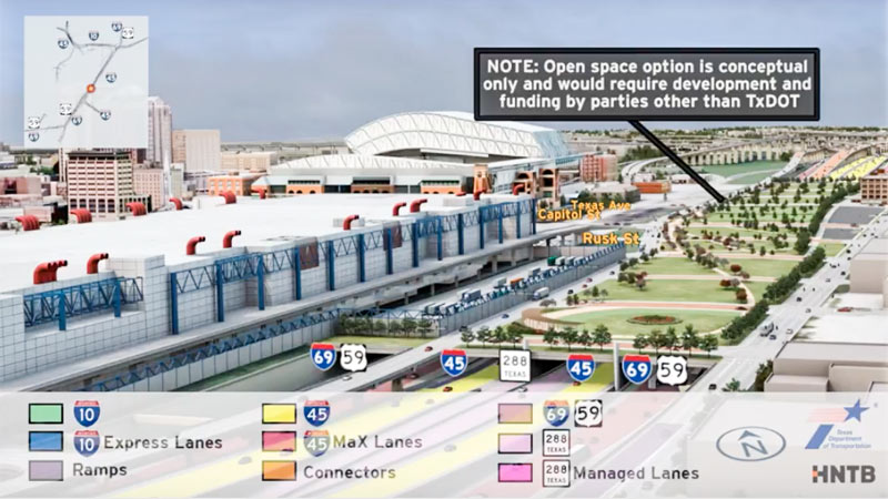
In between showing off various multicolored interchange tangles, the new flyover preview video of the huge changes proposed for I-45 North and the downtown freeway circuit glides viewers by a handful of areas where freeways will dive underground — while splicing in some new renderings of the tops of those tunnels-to-be as they could look, if somebody wanted to pay up to turn them into a park. (The animation is careful to emphasize once again that said parks would have to be developed and funded by a source other than TxDOT — and so far, there are no signs that anyone has stepped up.)
The rendering up top shows the would-be-parallel sections of 45, 59, and SH 288, running behind the convention district where 59 sits now — the whole bundle would be pulled down below flood grade and covered up, evidently with concrete if the park thing doesn’t work out. (A clip of just that section of the 10-minute animation is included above; a tiny rendered version of the Cheek Neal Coffee building can be spied along the edge of the freeway, though SEARCH Homeless Service’s new building one block north isn’t specifically drawn in next to it.)
The video also gives the section of 59 from Main to San Jacinto streets the same burial and dressup treatment:
Bridging the Gaps

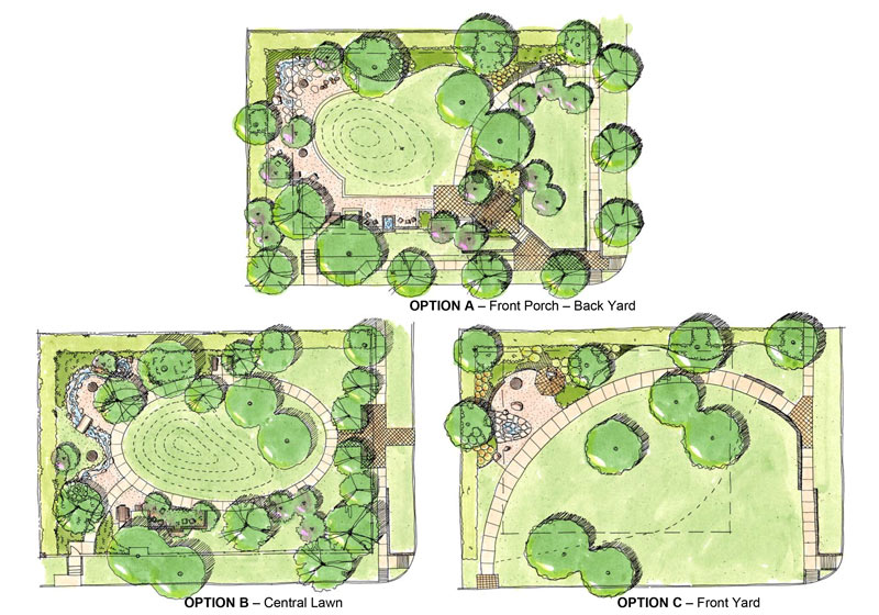
 Sunday’s the deadline for giving the city of West University some honest feedback on which of 3 proposed park layouts you think would best flatter this residential lot at 6446 Sewanee Ave. — along with any specific details you like about the other 2 options. The home’s former owner, architect James M. Hughes, passed away just over a year ago; Hughes bequeathed the property and some funds to West University for conversion into Jennie Elizabeth Hughes Park (named after his mother, who bought the empty lot back in 1928).
Option A of the choices highlights the corner lot’s time as a residence by adding a rocking-chaired, freestanding front porch as an entryway (though of a totally different design from the existing front porch). That option would also include a partial outline of the house’s foundation:
Sewanee Ave. Parking

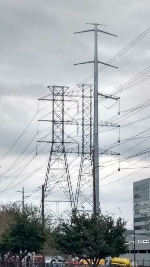
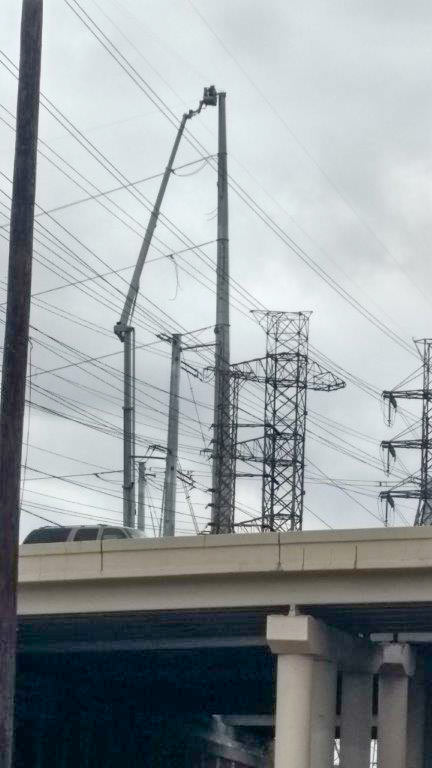 The view this week around Westpark Dr. at the West Loop includes both the old lattice towers currently holding CenterPoint’s electrical transmission lines and the taller, skinnier single pole models that will be taking over the gig. A reader captured some side-by-side portraits of the old towers and their replacements, which CenterPoint is deploying to raise the lines out of the way of TxDOT’s proposed future edits to the 610-59 interchange tangle. The cherry picker above is shown tethered to one of the new towers in the easement just west of 610; the top shot shows a pole up on the east side of the freeway between the Loop Central office midrises and the Danny Jackson Family Bark Park (which closed down last summer so CenterPoint could work on the land the county had been using as the park’s parking lot).
Here’s a ground-level shot at the base of an old-and-new tower pair just outside the dog park, with some Houston Garden Center inventory in the background for scale:
Bark Park Sparks

HOW THE GREEN THAT’S GREENING UP HOUSTON IS GROWING  Houston, which as Allyn West writes in the latest edition of Rice Business was “once defined primarily by its freeways and parking lots”, has been catching some attention outside the Outer Outer Loop for its surge in spending on parks and public spaces in the last decade or so, with more in the pipeline: in-progress and still-on-the-drawing-board plans include redos of Levy Park, Emancipation Park, Memorial Park, the Houston Arboretum, and turninge the Sims Bayou-straddling site of Glenbrook Park Golf Course into a Seuss-ical Houston Botanic Garden (shown above). Also on the radar of folks watching Houston’s slow greenification, West notes: the fact that hundreds of millions of dollars for the new or boosted green spaces have come from private fundraising and donations, and that most of the projects are being developed through public-private partnerships, which “allow certain parks to be chosen, so to speak, so as to be better stewarded by private philanthropy.”[Rice Business] Image of proposed Houston Botanic Garden: West 8

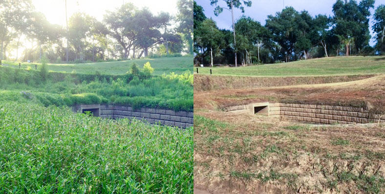
The folks at Save Buffalo Bayou send over some before-and-after photos of the Memorial Park boat launch and companion drainage structure just east of where the stream crosses beneath Woodway Dr. The group says the canoe and kayak put-in spot, on a 30-acre section of the park once used as an archery range, had been slowly greened back up by native river plants following the area’s multi-year closure and workover by the Uptown TIRZ, which involved some de-treeing work and the planting of some contractor-friendly non-native grasses on the newly reshaped slope.
Memorial Park director Jay Daniels told the group that the mowing was not planned, as park groups are currently trying to promote native plant growth in the park. Daniels said that he talked to a work group clearing some bayou access paths this weekend about removing some invasive Johnsongrass at the site; the conversation apparently led to some confusion, which led to mowing, which led to many folks being given a stern talking to.
Here’s a post-op look from July 2014 at the drainage setup (also intended to control bank erosion), partially covered in what appears to be eroding dirt and deposited sediment:
Trimming the Johnsongrass

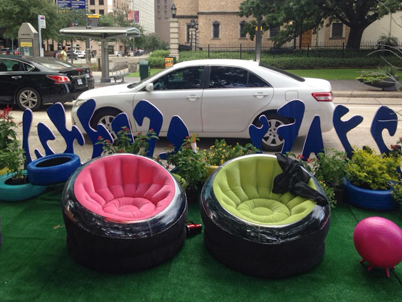
What’s all this sitting by the meters on the 500 block of McKinney St. today? Allyn West sends over some shots of the parking-spot-sized pocket parks currently occupying a few of Downtown’s on-street spaces. And you, too, can sit there, but only if you hustle: The ephemeral parklets are open for communal use until about 3 PM as part of the annual Park(ing) Day affair, now in its 12th year of instigating fleeting streetscape conversions in hundreds of cities around the world.
One of this year’s parks has its very own ideologically-conflicted seesaw:
Metered Park(ing)

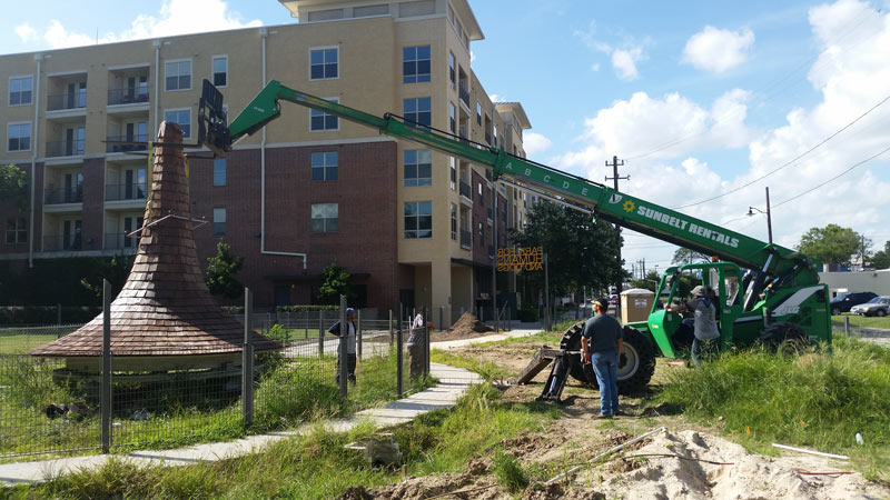
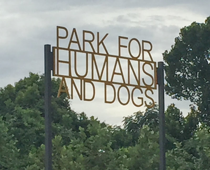 If the top of that pointy gazebo currently camped out at the about-to-open Park for Humans and Dogs by Glenwood Cemetery looks familiar, it’s because it’s been lurking around the Houston landscape for the last 115 years or so. This morning Susie Tommaney inventories the history and internet lore surrounding the house at 2201 Fannin St., from which a cupola nicknamed the Witch’s Hat was plucked just before the home’s 1997 demolition. “Not many people realize that the cupola was saved,” TIRZ 13 chair Claude Anello tells Swamplot, sending along the photo above of the hat’s installation, as well as his account of the hat’s rediscovery, reshaping, and ground-up career-building:
“I got a call a few years ago from Carl Detering, who had stored it in his outdoor storage yard at Detering’s on Washington. He was selling the property and told me that someone needed to get it or he would be forced to throw it in the dumpster. When I went to look at it, it had basically melted, [and] a tree had grown up through the middle of it (removed prior to photos) . . . Several people told us that it was beyond repair, but we dismantled it, had it reconstructed, and designed the park around it. It sat on the ground for a couple of years while we dealt with issues related to park design and permitting.”
Here’s a few tree-free glamour shots of the Hat prior to those reconstructive procedures, circa late 2013:
Sawyer St. Comeback

COMMENT OF THE DAY: WHY HOUSTON GREENSPACES CAN’T SHARE THE GREEN  “The big money is coming from private donations (Buffalo Bayou Partnership, Hermann Park Conservancy, Memorial Park Conservancy), most likely with ‘strings attached’ that require that they must be used in a specific park. I’m sure the Parks and Rec people would love to do more special projects in the neighborhood parks, but it’s also going to require someone with deep pockets to step up for them.” [slugline, commenting on The Places a 117-Ft.-Tall Yellow Corkscrew Tower Could Fit In Along Buffalo Bayou] Illustration: Lulu

Update, 3/24: BBP has updated the link to and language of the job posting; this story has been updated.
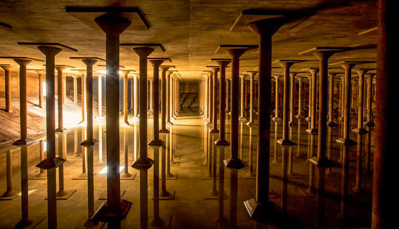
Wanted: Buffalo Bayou Partnership is seeking some college types folks to show people around the long-empty city drinking water reservoir near the intersection of Sabine St. and Memorial Dr., which the group also hopes to turn into a temporary art space some day. The “accidental cathedral” was only accessible by a set of hatches and 14-foot ladders back when BBP first examined it; a $1.2-million grant is being used to bring the 87,200-sq.-ft. underground space up to code for visitors.
The cistern, nicknamed after the 6th-century reservoir beneath Istanbul, lies just north of the Lee and Joe Jamail Skate Park beneath what will become a raised outdoor lawn intended for concerts and events at Buffalo Bayou Park. The 1927 reservoir was drained and decommissioned decades ago after it started leaking uncontrollably; the structure was planned for demolition and fill-in by the city around the time the park’s planners took an interest in the space, initially imagining uses like parking and mulch storage.
Work in the Underground
