WHAT COULD GO UNDER WHEN I-45 MOVES UNDERGROUND AND EAST OF DOWNTOWN 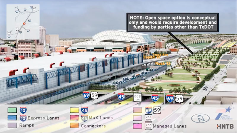 Jeff Balke tallies some of the expected carnage just east of Downtown should TXDoT proceed with its planned rerouting of I-45 from the west side to the east side of Downtown, widening the path of that stretch of Hwy. 59 (aka I-69) to Saint Emanuel St. Among the establishments expecting to have to shut down or relocate as a result of the expansion: the Bayou City Barber Shop, Vietnamese restaurant Huynh, Ahh Coffee, Tout Suite, one building of the Ballpark Lofts, low-income housing development Clayton Homes, a couple of nonprofits, SEARCH Homeless Services’ new building, the Loaves and Fishes soup kitchen — plus other assorted bars, barbecue joints, artist spaces, and office space. Among the questions Balke keeps hearing in reference to plans to put this portion of a new I-45-69 combo below grade, possibly (only if separate funding can be found) with a greenspace “cap” planted on top of it: “why [would] a freeway would be constructed lower than street level in a city that floods with seeming regularity, particularly when the highway in question is a hurricane evacuation route? TxDOT is quick to point out that we already have roadways below grade throughout the city that have not suffered major flooding problems since Tropical Storm Allison in 2001, which broke records and is widely considered a 500-year flood. Still, flooding is something the agency appears to have taken seriously. ‘No matter the situation, there’s a potential for flooding,‘ [TXDoT spokesperson] Perez explains, ‘but with anything below grade, additional pumps and detention ponds come into play.’ [Houston Press; previously on Swamplot] Rendering showing possible park behind GRB: HNTB and TxDOT
Sign up for the Newsletter
Freeways and Toll Roads

COMMENT OF THE DAY: LAY OFF THOSE FLOODED UNDERGROUND FREEWAYS, THEY’RE JUST DOING THEIR JOB  “Trenched roads include sumps that are capable of keeping the roadways from flooding from ordinary rain events, but are designed to become flooded in an emergency, acting as additional stormwater detention. Every cubic foot of stormwater that goes in there is a cubic foot that isn’t at the same elevation as city streets, businesses, and houses. It is a feature, not a bug.” [TheNiche, commenting on Watch as Unfunded Parks Appear on Top of Houston Freeways Before Your Very Eyes!]

In between showing off various multicolored interchange tangles, the new flyover preview video of the huge changes proposed for I-45 North and the downtown freeway circuit glides viewers by a handful of areas where freeways will dive underground — while splicing in some new renderings of the tops of those tunnels-to-be as they could look, if somebody wanted to pay up to turn them into a park. (The animation is careful to emphasize once again that said parks would have to be developed and funded by a source other than TxDOT — and so far, there are no signs that anyone has stepped up.)
The rendering up top shows the would-be-parallel sections of 45, 59, and SH 288, running behind the convention district where 59 sits now — the whole bundle would be pulled down below flood grade and covered up, evidently with concrete if the park thing doesn’t work out. (A clip of just that section of the 10-minute animation is included above; a tiny rendered version of the Cheek Neal Coffee building can be spied along the edge of the freeway, though SEARCH Homeless Service’s new building one block north isn’t specifically drawn in next to it.)
The video also gives the section of 59 from Main to San Jacinto streets the same burial and dressup treatment:
Bridging the Gaps

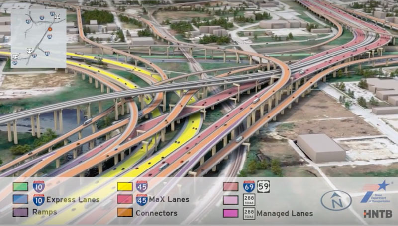
Having trouble sifting through some of the massive freeway jumbles in the latest plans for that major I-45 reroute between Downtown and the Beltway? This new video (making the rounds this month as TxDOT hosts a set of public meetings to chat about the project) may or may not help you out. The 10-minute animation shows off what the project plans look like in multicolored, car-spangled 3D action, dragging viewers slowly along the entire project route from Spur 521 up to Beltway 8.
The project plans pull 45 over to the east side of Downtown, to line up alongside US 59 and dive underground behind the George R. Brown convention center. Various flavors of new express lanes, managed lanes, managed express lanes, and connectors weave into and out of a massive new 45-59-10 junction as shown above, all labeled by color. Here’s a clip of the above video showing just that section of the animation:
Painted By Number

COMMENT OF THE DAY: WHAT IT TAKES TO LIVE NEXT TO THE FAST LANES  “The housing stock of the city has MANY luxury apartments located too close to comfort to a freeway. On I-10, the Sawyer Lofts’ north side [sits] right up on the freeway with some units being feet away from an exit ramp. Go further west and I-10 is lined with luxury apartments that look out at the freeway from a very uncomfortably close distance (basically two lanes away, plus a small setback). This is becoming a permanent fixture of the city. I’m not sure why anyone would voluntarily rent one of these, but the developers are banking on housing being in so short supply that someone will basically lose out when the music stops playing and there’s not a chair to sit in and they will be forced to rent one of these. I think that must be the game plan. Maybe they think if it’s common enough people will just subconsciously modify their lifestyle expectations in a big city to thinking its okay to live between 7 and 50 feet from one of the widest freeways in the world.” [Commenter7, commenting on The Downtown Apartments Caught Between a Freeway and a Curved Place] Illustration: Lulu

TXDOT TO PIERCE ELEVATED: YOUR YEARS ARE NUMBERED, PROBABLY  Pending a vote next month by the Texas Transportation Committee, some early-stage projects connected to TxDOT’s plan to reroute I-45 and the whole downtown freeway exchange system could be getting started a few years sooner than TxDOT officials initially thought they would, Dug Begley writes in the Chronicle. (Those early stages include the reworking of the bottleneck on northbound US-59 where Spur 527 now peels off 2 of the freeway’s lanes just before SH 288 merges into the mix.) The first few projects “are incremental compared to the overall plan,” writes Begley, but “officials say [the projects] are important and send the clear message: The I-45 freeway is relocating and the elevated portion along Pierce will be abandoned and maybe demolished within the next dozen years. . . .Work on revamping the freeway intersections is slated for late 2020 or early 2021.” [Houston Chronicle; previously on Swamplot] Photo of Pierce Elevated: Russell Hancock

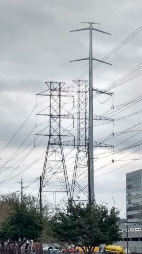
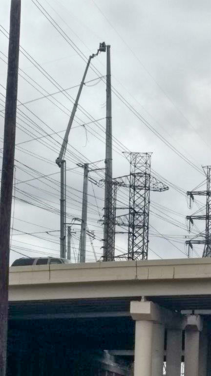 The view this week around Westpark Dr. at the West Loop includes both the old lattice towers currently holding CenterPoint’s electrical transmission lines and the taller, skinnier single pole models that will be taking over the gig. A reader captured some side-by-side portraits of the old towers and their replacements, which CenterPoint is deploying to raise the lines out of the way of TxDOT’s proposed future edits to the 610-59 interchange tangle. The cherry picker above is shown tethered to one of the new towers in the easement just west of 610; the top shot shows a pole up on the east side of the freeway between the Loop Central office midrises and the Danny Jackson Family Bark Park (which closed down last summer so CenterPoint could work on the land the county had been using as the park’s parking lot).
Here’s a ground-level shot at the base of an old-and-new tower pair just outside the dog park, with some Houston Garden Center inventory in the background for scale:
Bark Park Sparks

THE ODDS ON A PIERCE ELEVATED COMEDOWN 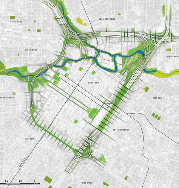 Writing in the latest issue of Texas Architect magazine — which is now debuting a redone website with a new web address and a new all-articles-are-now free policy — Ben Koush surveys the prospects for the raised section of I-45 now dividing Midtown from Downtown: “While there have been some plans floated around to convert the decommissioned section of the Pierce Elevated into Houston’s version of the Highline, most people I spoke with didn’t think that was going to happen, simply because TxDOT needs the money it could get from selling that right of way to private developers. Some still hold out hope that at least some of the land or maybe even a small section of the elevated roadway could be made into a public green space.” [Texas Architect; previously on Swamplot] Plan of “currently approved scheme” for I-45 rerouting around downtown, showing possible green space: SWA Group

B TEAM WANTS TO SEND THE GRAND PARKWAY WHERE THEY WEREN’T ALLOWED TO GO 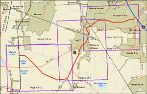 July 11th is the last day to make on-the-record comments about the route the Grand Parkway planners want to take from 288 to I-45 (known as Segment B of the 170-mile outer-outer loop). The finalized study documents published last week mention that proposed right-of-way runs across about 55 acres of wetlands — though that number isn’t precise: the document also mentions that the study authors couldn’t get permission to enter properties along 70 percent of the route, so the group had to use aerial photos to estimate. TxDOT’s desired route appears to hook in with SH288 at the intersection of CR 60 and follow the Brunner Ditch and South Texas Water Company canals southwest most of the way to SH35; from there it would swing back northeast just past Alvin, then eastward to hit I-45 where FM 646 does. [Previously on Swamplot]

WHAT HAPPENS WHEN YOU DECIDE TO REDO THAT DOWNTOWN FREEWAY PLAN IN YOUR SPARE TIME 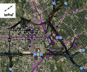 Tory Gattis reports in an update to his weekly column that TxDOT is looking over the alternative Downtown freeway plan put forth by Houston-based blog Purple City last week — to see if it can pull any ideas from it. The report, created by a semi-anonymous Houston-based engineer, includes detailed schematics, along with contextualized critiques of TxDOT’s most recently publicized version of plans to rework the interchanges of I-10, I-45, and 59 around Downtown. The Purple City plan appears to have a lot to offer: It would keep the Pierce Elevated as managed express lanes, while exploring options to make its street level pedestrian- and development-friendly. The alternative plan would require less right-of-way acquisition than TxDOT’s and eliminate left-hand exits. There are also bits about developing a new bus rapid transit line between Bellaire and UH, adding a a parallel bikeway network, and expanding the Downtown street grid. The 13-page report is available here; there’s also a scaled schematic of the entire plan. [Houston Strategies; Purple City; previously on Swamplot] Aerial schematic of (rotated) Downtown freeway alternative proposal: Purple City

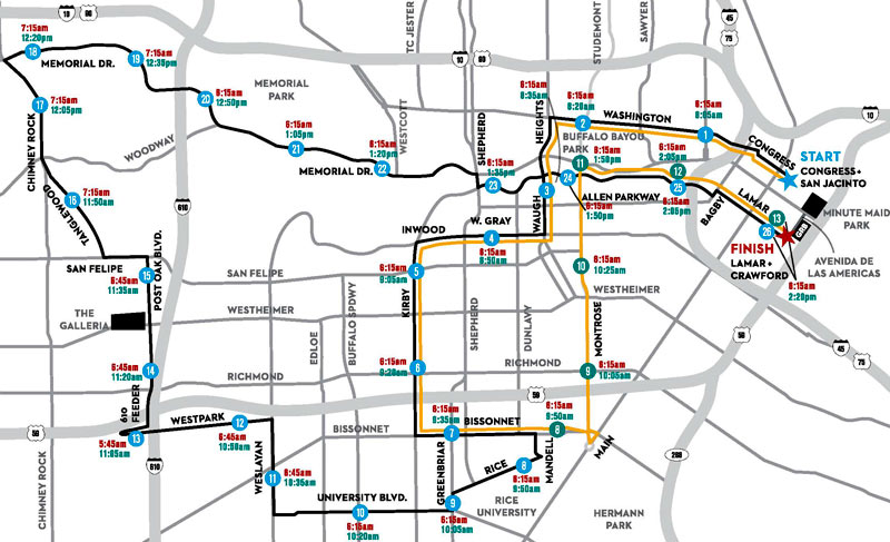
For a few early hours this Sunday, the Southwest Freeway will be the only conduit into or out of the box of land framed by Kirby Dr., Montrose Blvd., Bissonnet St. and W. Gray St. (give or take a traffic peninsula leading up to Allen Pkwy., which will also be closed for much of the morning).
The Houston Marathon will launch from 4 corrals leading to Congress Ave. at San Jacinto St., and loop through the city along the route outlined in black above. The Half Marathon route (outlined in yellow) will pant alongside until just before mile 8, when it will skive off north back toward the shared finish line at Discovery Green.
A larger version of the map is show in 2 parts below, complete with start and end times (in red and green respectively) of each mile marker’s street closure:
The Runaround

YOUR UPGRADE FROM SHEPHERD DR. TO THE NORTH FWY. WILL BE MUCH SMOOTHER STARTING TODAY 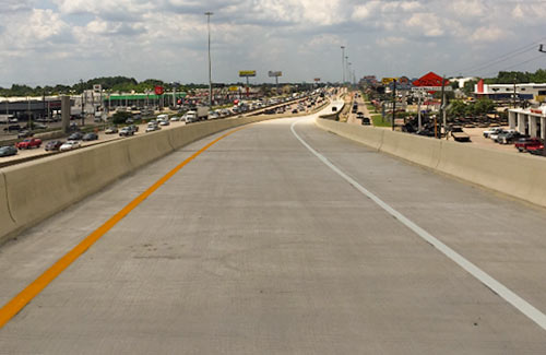 Today at noon TxDOT opened the brand new connector ramp pictured here, which has been under construction since December 2013. It links northbound traffic at the northern end of Shepherd Dr. to northbound I-45. Wasn’t there a way to get from Shepherd to I-45 already? Yes, but it brought cars into the freeway’s left lane. The new flyover crosses over the freeway to bring drivers onto I-45’s right lane; it hops over the Little York, Victory Blvd., and Veterans Memorial intersections on the way. A separate connector from I-45 south to Shepherd is scheduled to open later this summer. [TxDOT] Photo: TxDOT

SEWAGE NOW FLOWING PROPERLY UNDER GULF FWY. AGAIN 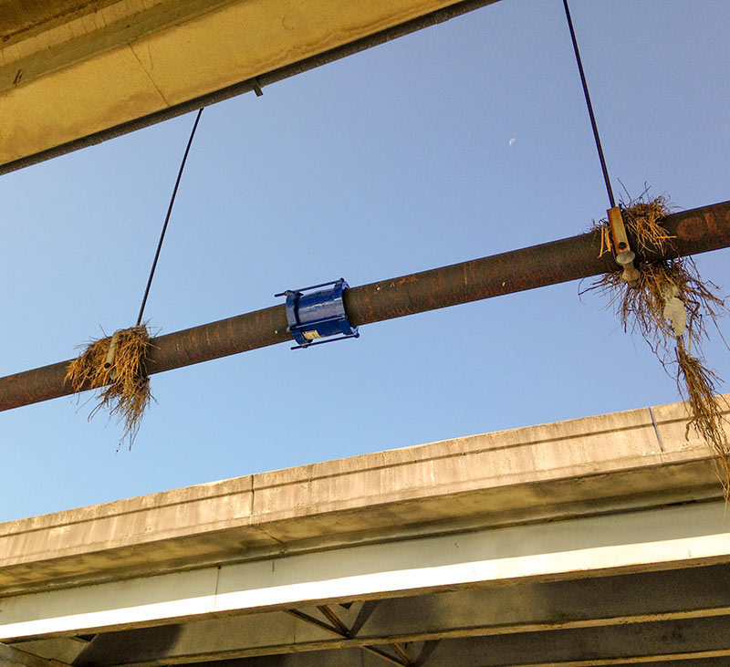 That pipe break spotted underneath an I-45 South overpass leaking what appeared to be raw sewage onto a concrete path adjacent to Brays Bayou last week has now been repaired — or at least covered with a new sleeve. A photo of the fix also shows flood-remnant bouquets still intact along the pipe’s length at the bayou crossing south of Idylwood and just east of Telephone Rd. Photo: Allyn West

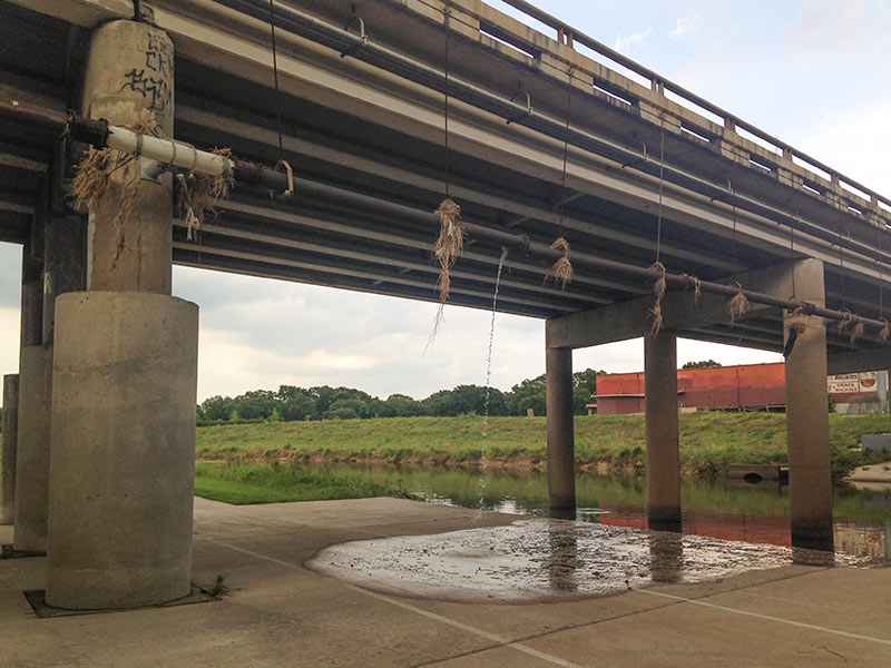
There’s a busted pipe hanging under the Gulf Fwy. overpass as it crosses Brays Bayou, just east of Telephone Rd. and south of Idylwood in the East End. The pics shown here were taken late yesterday afternoon, though some sort of liquid had been seen dripping from the break at various points over the weekend.
Grassy remnants of last week’s high water on Brays Bayou can still be seen hanging from various points along the pipe’s length:
Leftovers

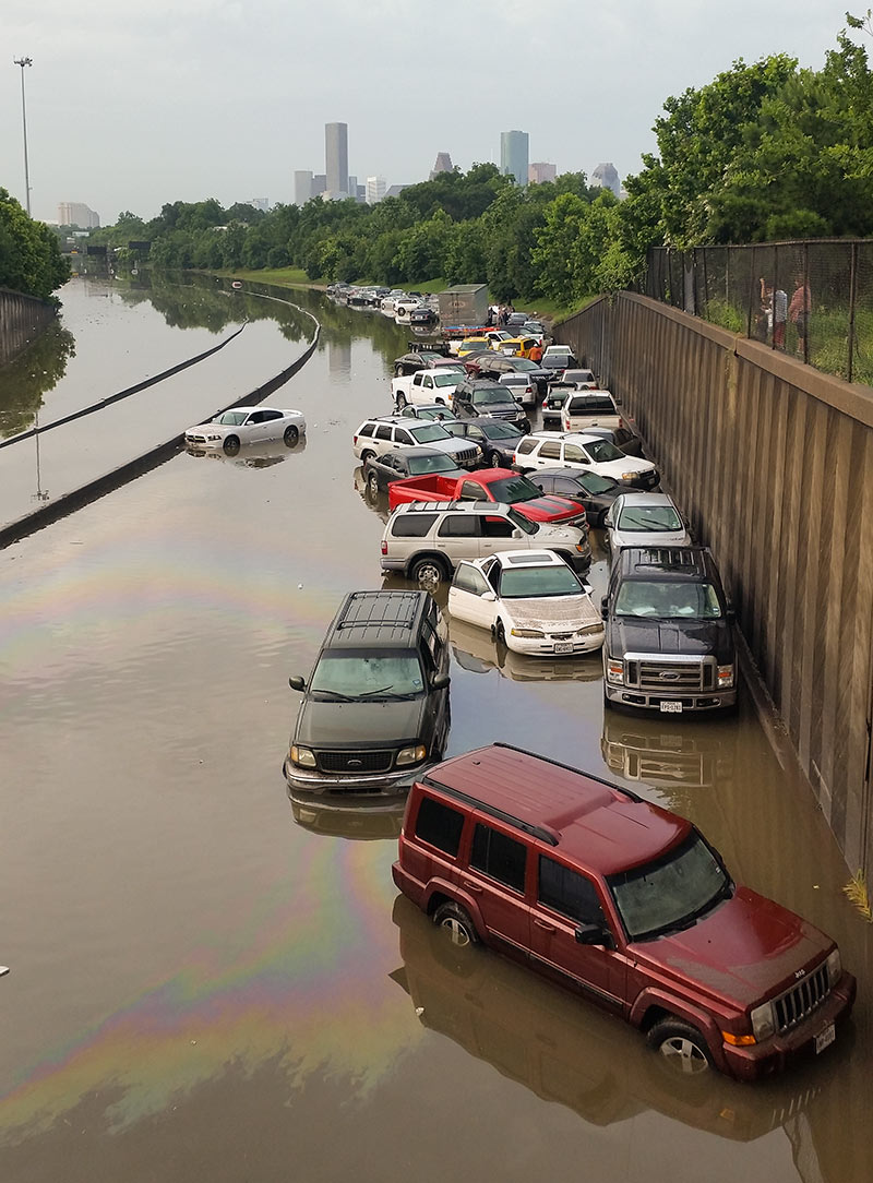
If you’re compiling a list of best photo spots for during or after another one of Houston’s every-dozen-years-or-so never-seen-anything-like-it flooding events, you’ll probably want to make room on it for the stretch of I-45 North between the N. Main St. and Patton St. exits. Back in 2001, images of cars and trucks floating along an insta-lake in this same spot made national news. And yesterday, pix of the automotive flotilla pictured above found their way to Facebook feeds and front pages around the globe.
But the low spot just north of Downtown wedged between Brooke Smith and the Near Northside was also a tough place to be when the water started rising, reports the Chronicle‘s Dane Schiller. Drivers found an early morning traffic jam in the rain changed nature quickly: “A surge was coming at them, squeezed by high barrier walls into the confines of the interstate. In less than 15 minutes, there was nothing to do but abandon ship.”
