MEMORIAL PARK GOLFERS WORRY THAT JUST-APPROVED COURSE REDESIGN COULD MESS UP THEIR HANDICAPS 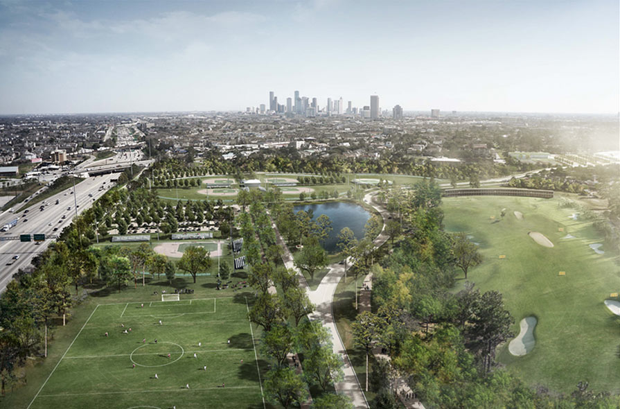 Houston’s city council just approved that $13.5 million plan to redesign the Memorial Park Golf Course so that the Houston Open can be held there in 2020. The vote passed unanimously at city hall this morning, but not before a few course regulars had a chance yesterday to vent about how the upgrades will skew the playing field: “I want to be an average Houstonian who plays with everybody else on the same level,” said Joseph Kratoville, who’s out there 4 or 5 times a week, adding that in its present state, the course is “the anti-country club. I get to meet people from all walks of life.” Baxter Spann, whose firm Finger Dye Spann renovated both the Memorial Park and Gus Wortham courses previously, spoke similarly: “I’m concerned that the focus may be on making this a tour-level course without adequate regard for the everyday golfer,” he told the council. The course closes tomorrow, although the driving range and on-site Becks Prime will remain open. It’ll need to be back open by November 1 in order for the PGA Tour stop to be held there the following year, report the Chronicle’s David Barron and Robert Downen. Meanwhile, 2019’s Houston Open will take place at the Golf Club of Houston (in Humble) like it has since relocating there in 2003. [Houston Chronicle] Rendering: Nelson Byrd Woltz
Tag: Memorial-Park
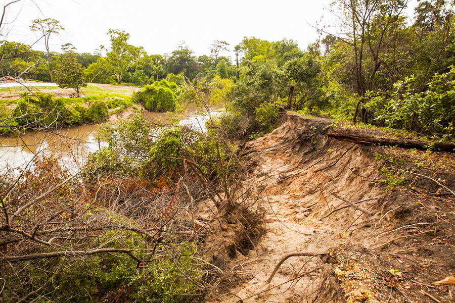
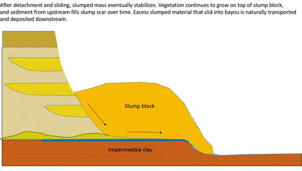
The folks fighting a longstanding battle to prevent the reconfiguration of a section of Buffalo Bayou fronting the southeast corner of Memorial Park and the River Oaks Country Club have posted a remarkable series of images showing how a section of the bayou’s bank at the Hogg Bird Sanctuary responded on its own over the course of 2 years to a soil collapse suffered during the 2015 Memorial Day flood. The geologists behind Save Buffalo Bayou claim that the promoters of the Harris County Flood Control District’s proposed $12 million Memorial Park Demonstration Project they’re trying to stop have mistaken a natural bayou-bank process called vertical slumping (or sloughing) for erosion, and that attempting to stabilize the bayou banks to fix the supposed erosion will leave the area “a wasteland of denuded and weakened banks.”
But you don’t have to buy or even follow the riverine logic the organization steps through in a lengthy article posted to its website earlier this week to appreciate one of the examples of waterway-bank adaptation exhibited there. The first image (at top) shows the immediate aftermath of the Memorial Day storm or 2 years ago on the high bluff facing the bayou at the Hogg Bird Sanctuary in Memorial Park, which stands at the downstream end of the proposed project area. According to the organization, an HCFCD consultant claims that this is one of 4 spots within the bayou area that suffers from severe lateral erosion. But to Save Buffalo Bayou, this isn’t erosion; it’s just a slump, which is what bayous do naturally, and which on their own create the distinctive bluffs on the bayou’s banks. There’s no way to fix a slump, the organization’s geologists say — if left alone it’ll restore itself.
Here’s their photo evidence. The second photo, also from June 2015, shows the slumping — and downed trees:
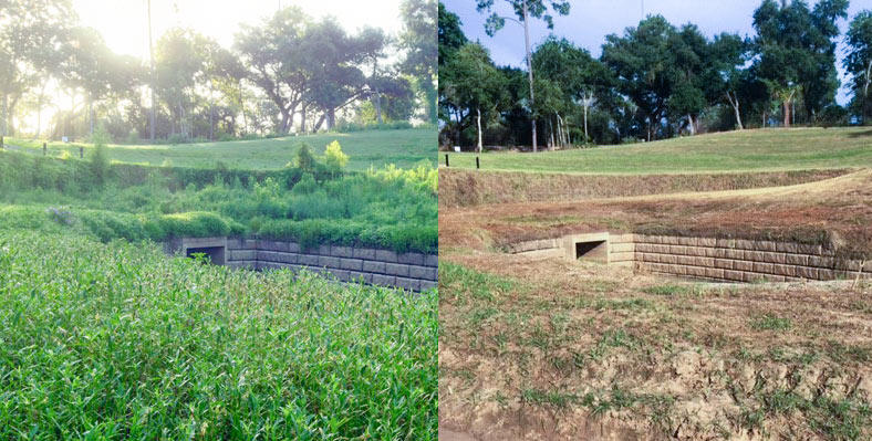
The folks at Save Buffalo Bayou send over some before-and-after photos of the Memorial Park boat launch and companion drainage structure just east of where the stream crosses beneath Woodway Dr. The group says the canoe and kayak put-in spot, on a 30-acre section of the park once used as an archery range, had been slowly greened back up by native river plants following the area’s multi-year closure and workover by the Uptown TIRZ, which involved some de-treeing work and the planting of some contractor-friendly non-native grasses on the newly reshaped slope.
Memorial Park director Jay Daniels told the group that the mowing was not planned, as park groups are currently trying to promote native plant growth in the park. Daniels said that he talked to a work group clearing some bayou access paths this weekend about removing some invasive Johnsongrass at the site; the conversation apparently led to some confusion, which led to mowing, which led to many folks being given a stern talking to.
Here’s a post-op look from July 2014 at the drainage setup (also intended to control bank erosion), partially covered in what appears to be eroding dirt and deposited sediment:
STOP TRYING TO FIX BUFFALO BAYOU, SAYS SAVE BUFFALO BAYOU 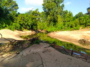 The waterway enthusiasts at Save Buffalo Bayou just issued their report on their recent tours of the waterway, with an eye toward how the scene has changed in the wake of the Tax Day flooding and the extended high flows from the try-not-to-make-things-worse paced drainage of the Addicks and Barker reservoirs. The photo above, taken during the organization’s scouting, shows an area of the bayou where the river channel dug through a curve and moved over, such that some landmarks previously on the north bank are now on the south side. The authors take issue with a number of current and proposed plans to keep the bayou’s banks in place, and suggest that the best way to end up with a relatively stable channel is to step back and let geology do the job: “When the bayou’s banks slump or collapse, the brush and fallen trees left in place collect sediment during subsequent high waters, gradually rebuilding naturally reinforced banks. These new nature-built banks are better able to withstand subsequent floods as well as the more powerful flows being released from the dams . . . The bayou itself then reseeds these and other sandy areas with the proper succession of plants that first colonize then stabilize the sediment, turning sand into soil, preparing the way for seedlings of trees. It’s part of the natural function of riverine flooding that we rarely have opportunity to observe, especially in the middle of a city where we have dug up and covered in concrete most of our bayous and streams.” [Save Buffalo Bayou; previously on Swamplot] Photo: Save Buffalo Bayou
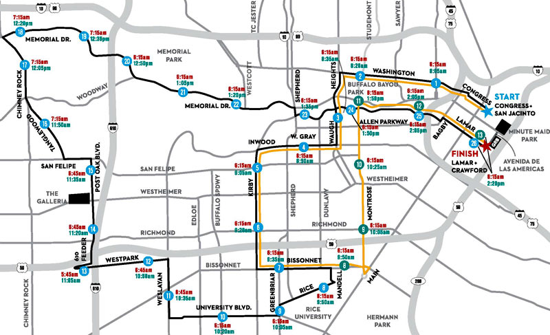
For a few early hours this Sunday, the Southwest Freeway will be the only conduit into or out of the box of land framed by Kirby Dr., Montrose Blvd., Bissonnet St. and W. Gray St. (give or take a traffic peninsula leading up to Allen Pkwy., which will also be closed for much of the morning).
The Houston Marathon will launch from 4 corrals leading to Congress Ave. at San Jacinto St., and loop through the city along the route outlined in black above. The Half Marathon route (outlined in yellow) will pant alongside until just before mile 8, when it will skive off north back toward the shared finish line at Discovery Green.
A larger version of the map is show in 2 parts below, complete with start and end times (in red and green respectively) of each mile marker’s street closure:
COMMENT OF THE DAY: WHERE’S OUR MEMORIAL PARK BYPASS?  “This ramp will now allow more traffic to use Shepherd as an alternate to the freeway system. Thus creating longer delays for those who use surface roads to travel. What is sorely required is a road that would flyover Memorial Park adding a much needed way to travel from the inner loop north. Currently, the only options are the West Loop and Kirby/Shepherd. Both of which are overly congested at most times of the day. It doesn’t help that Shepherd is down to two lanes from four in stretch from Westheimer to Dallas while the city installs much needed storm drainage.” [jgbiggs, commenting on Your Upgrade from Shepherd Dr. to the North Fwy. Will Be Much Smoother Starting Today] Illustration: Lulu
COMMENT OF THE DAY: WILL THE NEW BIKE TRAIL SYSTEM BE THIS SHOCKING?  “Here’s something a little off topic but has to do with putting trails on power easements. Has anyone ever experienced what happens when you ride under the lines down the dirt road in Memorial Park? The electromagnetic field actually shocks you where you are touching the frame or handlebars especially during peak Summer usage hours and when sweaty. Not sure if that’s ever been addressed.” [j, commenting on FPSF Moving Next to the Astrodome; I-10 Toll Hike Delay; Secrets of the I-45 Redo Plan] Illustration: Lulu
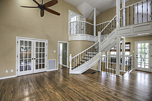
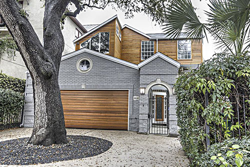
The front yard of a property in Camp Logan’s Minola section is nice and shady. So’s the driveway that takes up most of it, though it shares critical space with a well-established tree. Both are located across from Camp Logan Park, or whatever folks call the grasslands formed by a triangle of streets at Wanita Pl. and Taggart St. The 1940 home (the listing calls it 1980) re-renovated its 1995 renovations earlier this year. After 2 weeks on the market at $1.2 million, the 2-toned home took a brief breather on Friday before re-listing. The property’s price tag took a trim and is now asking $1.1 million.

The landscape architecture firm working on a new master plan for Memorial Park is proposing to put portions of Memorial Dr. in tunnels to allow better connections between the long-separated north and south sections of the 1,500-acre space. Drawings shown at a public meeting Wednesday demonstrated a range of strategies Nelson Byrd Woltz is considering to link some of the 24 separate sections of the park so that they are freely accessible to visitors without hazarding traffic. Tunnels over the existing roadway would be covered by an 800-ft. long “land bridge” planted with grass and trees, reports the Chronicle‘s Molly Glentzer:
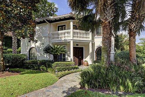
Does this Mediterranean-ian home in Crestwood actually like its view of Memorial Park across the street — or not? Judging from the corner lot’s tree canopies and the 1999 home’s extensive use of plantation shutters, it’s a little hard to tell. When a new agency re-re-re-relisted it a month ago, the property’s asking price came to $1.7 million. A series of 3 previous listings dating back to March 2013 shows pricing efforts targeted $1.975 million at first, but backed down to $1.935 million in September 2013, $1.895 million in February 2014, and $1.795 million in April.
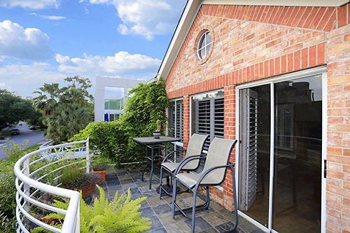
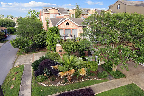
Unlike the other townhomes in this 1992 Camp Logan 4-pak, the corner slot’s deep driveway is on the side. That frees up front-lot space for a gated entry and extra landscaping, all on view from the curvy balcony, as is Camp Logan Park across the street. The property stacks its taller portion on the back lot. Last week, the listing hit market with a $500,000 asking price.
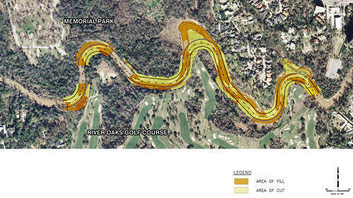
in this week’s Houston Press, writer Dianna Wray wades into the murky waters surrounding the Harris County Flood Control District’s plan to move and rebuild the banks of Buffalo Bayou where it winds between Memorial Park and the River Oaks Country Club. The method of “natural channel design” the district plans to use in the $6 million project is meant to keep the bayou in place, using downed trees instead of concrete. But weren’t bayous born to wiggle? “If the Army Corps of Engineers approves the Memorial Park Demonstration Project permit application,” Wray writes, “construction workers could move in by the end of this year, using heavy equipment and saws to reshape the bayou according to a pattern that should, if the method is successful, lock the waterway into a form it will hold for generations to come. If the effort fails, the entire project could be blown down the river by one heavy flood, leaving nothing but naked, unprotected soil where the last of an ancient forest once stood.”
- Fighting for Control: Can Buffalo Bayou Survive the Latest Plan to Save It? [Houston Press]
- Conservationists have an eye turned to Buffalo Bayou project [Houston Chronicle ($)]
- Memorial Park Demonstration Project [HCFCD]
Plan of Memorial Park Demonstration Project: Harris County Flood Control District

Here’s a concept that HKS came up with for a site just behind the Hotel Granduca, Montebello, and Villa d’Este towers in Uptown Park. The concept shows how it might go if you wanted to build a conference center and a combo hotel-condo tower on 14 green acres between Tilbury and N. Wynden off S. Post Oak, just west of the Loop. This rendering shows the boxy exterior of what appears to be the conference center flanking a linear park shooting off from the banks of Buffalo Bayou.
WHAT’S BEST FOR BUFFALO BAYOU? 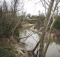 Let it flow, or let it be? Environmentalists and the Harris County Flood Control District disagree — at least when it comes to the 1.5-mile stretch that contributes to the “jungly ecosystem” of the Hogg Bird Sanctuary in Memorial Park, reports the Houston Chronicle’s Lisa Gray. A “restoration” plan proposed by the flood controllers, explains Gray, “would change the bayou’s course in places, fill in an oxbow here, reinforce banks there, widen the bayou’s channel, raising and lowering landmasses and generally move an enormous amount of dirt. [They argue] that the proposed measures are desperately needed to reduce erosion and improve water quality.” They’d do it here as they did it at Meyer Park along Spring Creek, reports Gray. But the environmentalists don’t seem to consider that to have been a “restoration” project, really: “‘Look at that!” [Memorial Park Conservancy board member Katy Emde] told me, outraged, showing me a picture of Meyer Park on her phone. ‘There’s no diversity! It’s not natural! It’s not habitat! It’s horrifying.'” [Houston Chronicle ($); previously on Swamplot] Photo of Hogg Bird Sanctuary: Bayou Shuttle
MAYOR PARKER’S PLAN FOR A BIGGER, FRIENDLIER UPTOWN TIRZ  Why not both? Yesterday, Mayor Parker announced a $556 million plan that, if approved by city council on April 24, would fund the seemingly unrelated instead-of-light rail Post Oak BRT and Memorial Park reforestation: Uptown would annex 1,768 acres of property into the TIRZ, and a gradual increase in tax revenue over the next 25 years would help to keep the BRT operational and implement a program of park improvements. Those would include, says Houston Parks and Rec director Joe Turner in a city press release, “erosion control, removal of invasive non-native plants, the reestablishment of native grasslands and forests and facility needs.” Still: Only 36 acres of the property roped in for annexation would be taxable. And does this plan mean that BRT — first thought to be up and running by 2017 — will be delayed? Don’t worry, says Uptown Management District president John Breeding. Besides what will be generated by the more environmentally friendly TIRZ, money for BRT will come from TxDOT and — if approved by a vote on April 26 — Transportation Improvement Program grants from the Houston-Galveston Area Council. [City of Houston; previously on Swamplot] Drawing of Post Oak BRT: Uptown Management District

